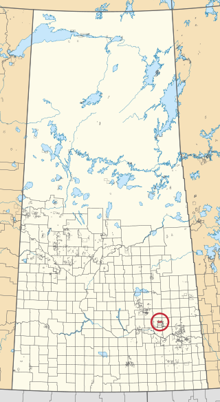
Baring [1] is an unincorporated community in Saskatchewan. It is south-east of Grenfell, just off Highway 47.

Baring [1] is an unincorporated community in Saskatchewan. It is south-east of Grenfell, just off Highway 47.

Abernethy is a village in the Canadian province of Saskatchewan within the Rural Municipality of Abernethy No. 186 and Census Division No. 6. It is about one hour east of Regina, one hour west of Yorkton, and approximately five hours northwest of Winnipeg. To the south of Abernethy lies the Qu'Appelle Valley in which Katepwa Beach is located.
Neudorf is a village in the Canadian province of Saskatchewan within the Rural Municipality of McLeod No. 185 and Census Division No. 5. It is on Highway 22 east of Lemberg, and Abernethy, and west of Killaly.
Candiac is an organized hamlet located at the intersection of Highway 48 and Highway 617 in the southeast quadrant of Saskatchewan, Canada. It is directly south of Wolseley, and between Montmartre and Glenavon, approximately one hour's drive southeast of the provincial capital Regina. It is no longer listed as a separate community by Statistics Canada, and is considered part of the Rural Municipality of Montmartre #126. The population within the community's boundary is less than 50. Besides some bush on the northern end of the town, it is surrounded by open fields and pasture.
Lemberg is a town in Saskatchewan, Canada. It was founded by ethnic German immigrants from Lviv, for which the German name was "Lemberg", as part of the Great Economic Emigration away from Galicia and Lodomeria starting in the mid to late-1800s.

Francis is a town in the province of Saskatchewan in Canada. The town is 67 km southeast of Regina and 50 km north of Weyburn at the intersection of Highway 33 and Highway 35.
Duff is a special service area in the Canadian province of Saskatchewan within the Rural Municipality of Stanley No. 215 and Census Division No. 5. It is approximately 122 kilometres (76 mi) north-east of the city of Regina, 66 kilometres (41 mi) south-west of Yorkton, and 20 kilometres (12 mi) west of Melville. The community is situated along Highway 10.
Fenwood is a village in the Canadian province of Saskatchewan within the Rural Municipality of Stanley No. 215 and Census Division No. 5.
Kendal is a village in the Canadian province of Saskatchewan within the Rural Municipality of Montmartre No. 126 and Census Division No. 6. The village is located 77 km southeast of the City of Regina on Highway 48.
Taylor Beach is a hamlet in the Canadian province of Saskatchewan.
Bechard is an unincorporated community in Saskatchewan near Riceton.

The Okanese First Nation is a Cree-Saulteaux First Nation band government in Balcarres, Saskatchewan, Canada.

The Frenchman River,, also known locally as the Whitemud River, is a river in Saskatchewan, Canada and Montana, United States. It is a tributary of the Milk River, itself a tributary of the Missouri and in turn a part of the Mississippi River watershed that flows to the Gulf of Mexico.
Summerberry is an organized hamlet in the Rural Municipality of Wolseley No. 155, Saskatchewan, Canada that previously held village status until December 31, 1972. It is located between the towns of Wolseley and Grenfell on Highway 1, 15 km east of Wolseley.

Assiniboine 76 is an Indian reserve of the Carry the Kettle Nakoda First Nation in Saskatchewan. It is 80 kilometers east of Regina. In the 2016 Canadian Census, it recorded a population of 443 living in 182 of its 214 total private dwellings. In the same year, its Community Well-Being index was calculated at 54 of 100, compared to 58.4 for the average First Nations community and 77.5 for the average non-Indigenous community.

Star Blanket 83 is an Indian reserve of the Star Blanket Cree Nation in Saskatchewan. It is about 18 kilometres (11 mi) north-east of Fort Qu'Appelle. In the 2016 Canadian Census, it recorded a population of 175 living in 48 of its 59 total private dwellings. In the same year, its Community Well-Being index was calculated at 50 of 100, compared to 58.4 for the average First Nations community and 77.5 for the average non-Indigenous community.

Little Black Bear 84 is an Indian reserve of the Little Black Bear First Nation in Saskatchewan. It is about 19 kilometres (12 mi) east of Fort Qu'Appelle. In the 2016 Canadian Census, it recorded a population of 137 living in 34 of its 43 total private dwellings. In the same year, its Community Well-Being index was calculated at 51 of 100, compared to 58.4 for the average First Nations community and 77.5 for the average non-Indigenous community.

Okanese 82 is an Indian reserve of the Okanese First Nation in Saskatchewan. It is about 16 kilometres (9.9 mi) north-east of Fort Qu'Appelle. In the 2016 Canadian Census, it recorded a population of 175 living in 56 of its 69 total private dwellings. In the same year, its Community Well-Being index was calculated at 57 of 100, compared to 58.4 for the average First Nations community and 77.5 for the average non-Indigenous community.

Peepeekisis 81 is an Indian reserve of the Peepeekisis Cree Nation in Saskatchewan. It is about 14 kilometres (8.7 mi) east of Fort Qu'Appelle. In the 2016 Canadian Census, it recorded a population of 491 living in 135 of its 146 total private dwellings. In the same year, its Community Well-Being index was calculated at 53 of 100, compared to 58.4 for the average First Nations community and 77.5 for the average non-Indigenous community.

Standing Buffalo 78 is an Indian reserve of the Standing Buffalo Dakota Nation in Saskatchewan. It is about 8 kilometres (5.0 mi) north-west of Fort Qu'Appelle. In the 2016 Canadian Census, it recorded a population of 569 living in 184 of its 198 total private dwellings. In the same year, its Community Well-Being index was calculated at 59 of 100, compared to 58.4 for the average First Nations community and 77.5 for the average non-Indigenous community.

Wa-pii-moos-toosis 83A is an Indian reserve of the Star Blanket Cree Nation in Saskatchewan. In 2016, its Community Well-Being index was calculated at 61 of 100, compared to 58.4 for the average First Nations community and 77.5 for the average non-Indigenous community. The name of the locality means "White Calf".
50°15′04″N103°03′40″W / 50.25111°N 103.06111°W