Welwyn, Saskatchewan

Last updated

Welwyn
Canada Saskatchewan location map.svg
Red pog.svg
Welwyn
Canada location map 2.svg
Red pog.svg
Welwyn
Coordinates: 50°19′30″N101°31′10″W / 50.324984°N 101.519314°W / 50.324984; -101.519314
Country Canada
Province Saskatchewan
Census division 5
Rural municipality Moosomin No. 121
Incorporated (village) [1] June 11, 1907
Dissolved (special service area) [2] May 1, 2018
Area
 (2016) [3]
  Land0.64 km2 (0.25 sq mi)
Population
 (2016) [3]
  Total133
  Density208.1/km2 (539/sq mi)
Time zone UTC-6 (CST)
Area code 306
Highways

Welwyn is a special service area in the Rural Municipality of Moosomin No. 121, Saskatchewan, Canada that held village status prior to May 2018. It is located in the southeastern portion of Saskatchewan, near the Manitoba border. The community was named for Welwyn, in Hertfordshire, England at the suggestion of James Wake, who homesteaded just across the Manitoba border. [4] In 2016, the population was 133.

Contents

History

Welwyn incorporated as a village on June 11, 1907. [1] It restructured on May 1, 2018, relinquishing its village status in favour of becoming a special service area under the jurisdiction of the Rural Municipality of Moosomin No. 121. [2]

Demographics

In the 2016 Census of Population conducted by Statistics Canada, Welwyn recorded a population of 133 living in 61 of its 61 total private dwellings, a

Welwyn Centennial Regional Park

Welwyn Centennial Regional Park ( 50°20′27″N101°31′11″W / 50.3408°N 101.5197°W / 50.3408; -101.5197 ) [5] is a regional park about 1.6 kilometres (0.99 mi) north of Welwyn in the neighbouring RM of Rocanville No. 151. It is on the south side of the mile-long reservoir on Beaver Creek. [6] The park was built by volunteers in 1967 to commemorate the Canadian Centennial. Activities at the park include camping, swimming, picnicking, boating, and hiking through a forest of native oak trees. [7] [8]

See also

Related Research Articles

<span class="mw-page-title-main">Togo, Saskatchewan</span> Village in Saskatchewan, Canada

Togo is a village in the Canadian province of Saskatchewan within the Rural Municipality of Cote No. 271 and Census Division No. 9. It is 800 metres west of the Manitoba border and approximately 72 km (45 mi) northeast of the City of Yorkton.

<span class="mw-page-title-main">Rural Municipality of Maple Bush No. 224</span> Rural Municipality in Saskatchewan, Canada

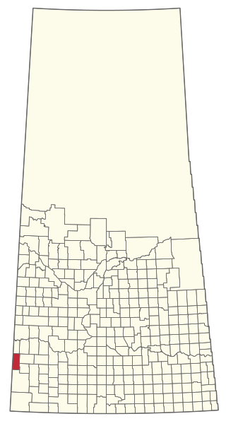
The Rural Municipality of Maple Bush No. 224 is a rural municipality (RM) in the Canadian province of Saskatchewan within Census Division No. 7 and SARM Division No. 2. It is located in the southwest portion of the province.

Arran is a special service area in the Canadian province of Saskatchewan within the Rural Municipality of Livingston No. 331 and Census Division No. 9. It held village status between 1916 and 2022.

<span class="mw-page-title-main">Division No. 5, Saskatchewan</span> Census division of Saskatchewan, Canada

Division No. 5 is one of eighteen census divisions in the province of Saskatchewan, Canada, as defined by Statistics Canada. It is located in the east-southeastern part of the province, bordering Manitoba. The most populous community in this division is Melville.

Saltcoats is a town in east-central Saskatchewan near the Manitoba border in Canada. The town's population was 474 in 2011. It was built in the late 19th century, and its economy was driven by the railway. There is no longer passenger service to the town.

<span class="mw-page-title-main">Rural Municipality of Senlac No. 411</span> Rural municipality in Saskatchewan, Canada

The Rural Municipality of Senlac No. 411 is a rural municipality (RM) in the Canadian province of Saskatchewan within Census Division No. 13 and SARM Division No. 6. Located in the west-central portion of the province, it is adjacent to the Alberta boundary.

<span class="mw-page-title-main">Gainsborough, Saskatchewan</span> Village in Saskatchewan, Canada

Gainsborough is a village in the Canadian province of Saskatchewan within the Rural Municipality of Argyle No. 1 and Census Division No. 1. A farming community, the village is located on Highway 18 in the southeastern corner of Saskatchewan. Gainsborough is approximately 6 km (3.7 mi) from the Manitoba border, and 19 km (12 mi) from the North Dakota, United States border. The first post office was established on April 1, 1884 as the community of Antler. On September 1, 1885 the name of the community changed to Gainsborough, after Gainsborough, Lincolnshire in England, which was the former home of J. J. Sadler, an early settler.

Moosomin is a town in southern Saskatchewan founded in 1882. It is 20 kilometres west of the provincial boundary between Saskatchewan and Manitoba.

<span class="mw-page-title-main">Rural Municipality of Enterprise No. 142</span> Rural municipality in Saskatchewan, Canada

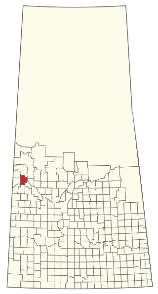
The Rural Municipality of Enterprise No. 142 is a rural municipality (RM) in the Canadian province of Saskatchewan within Census Division No. 8 and SARM Division No. 3. It is located in the southwest portion of the province.

<span class="mw-page-title-main">Mankota</span> Village in Saskatchewan, Canada

Mankota is a village in the Canadian province of Saskatchewan within the Rural Municipality of Mankota No. 45 and Census Division No. 3. The village is located on Highway 18, about 150 km southeast of the City of Swift Current. It is also near the villages of Kincaid, Ferland, Hazenmore, and Glentworth.

<span class="mw-page-title-main">Rural Municipality of Moosomin No. 121</span> Rural Municipality in Saskatchewan, Canada

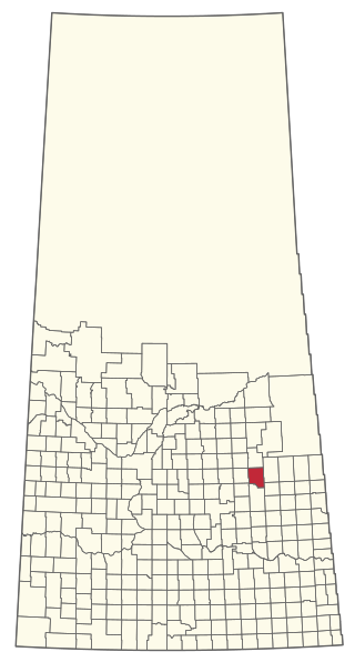
The Rural Municipality of Moosomin No. 121 is a rural municipality (RM) in the Canadian province of Saskatchewan within Census Division No. 5 and SARM Division No. 1. It is located in the southeast portion of the province.

<span class="mw-page-title-main">Rural Municipality of Britannia No. 502</span> Rural municipality in Saskatchewan, Canada

The Rural Municipality of Britannia No. 502 is a rural municipality (RM) in the Canadian province of Saskatchewan within Census Division No. 17 and SARM Division No. 6. It is located in the west-central portion of the province.

<span class="mw-page-title-main">Rural Municipality of Eldon No. 471</span> Rural municipality in Saskatchewan, Canada

The Rural Municipality of Eldon No. 471 is a rural municipality (RM) in the Canadian province of Saskatchewan within Census Division No. 17 and SARM Division No. 6.

<span class="mw-page-title-main">Rural Municipality of Mayfield No. 406</span> Rural Municipality in Saskatchewan, Canada

The Rural Municipality of Mayfield No. 406 is a rural municipality (RM) in the Canadian province of Saskatchewan within Census Division No. 16 and SARM Division No. 6.

<span class="mw-page-title-main">Rural Municipality of Clinworth No. 230</span> Rural Municipality in Saskatchewan, Canada

The Rural Municipality of Clinworth No. 230 is a rural municipality (RM) in the Canadian province of Saskatchewan within Census Division No. 8 and SARM Division No. 3.

<span class="mw-page-title-main">Rural Municipality of Ituna Bon Accord No. 246</span> Rural Municipality in Saskatchewan, Canada

The Rural Municipality of Ituna Bon Accord No. 246 is a rural municipality (RM) in the Canadian province of Saskatchewan within Census Division No. 10 and SARM Division No. 4.

<span class="mw-page-title-main">Rural Municipality of Sasman No. 336</span> Rural municipality in Saskatchewan, Canada

The Rural Municipality of Sasman No. 336 is a rural municipality (RM) in the Canadian province of Saskatchewan within Census Division No. 10 and SARM Division No. 4.

<span class="mw-page-title-main">Rural Municipality of Last Mountain Valley No. 250</span> Rural Municipality in Saskatchewan, Canada

The Rural Municipality of Last Mountain Valley No. 250 is a rural municipality (RM) in the Canadian province of Saskatchewan within Census Division No. 11 and SARM Division No. 5.

<span class="mw-page-title-main">Rural Municipality of Pleasantdale No. 398</span> Rural Municipality in Saskatchewan, Canada

The Rural Municipality of Pleasantdale No. 398 is a rural municipality (RM) in the Canadian province of Saskatchewan within Census Division No. 14 and SARM Division No. 4.

References

  1. 1 2 "Urban Municipality Incorporations" (PDF). Saskatchewan Ministry of Government Relations. p. 14. Archived from the original on October 15, 2014. Retrieved October 13, 2019.
  2. 1 2 "Restructuring of the Village of Welwyn" (PDF). The Saskatchewan Gazette. April 20, 2018. pp. 844–849. Retrieved October 13, 2019.
  3. 1 2 3 "Population and dwelling counts, for Canada, provinces and territories, and census subdivisions (municipalities), 2016 and 2011 censuses – 100% data (Saskatchewan)". Statistics Canada. February 20, 2019. Retrieved October 13, 2019.
  4. Barry, Bill (September 2005). Geographic Names of Saskatchewan . Regina, Saskatchewan: People Places Publishing, Ltd. p.  449. ISBN   1-897010-19-2.
  5. "Welwyn Centennial Regional Park". Canadian Geographical Names Database. Government of Canada. Retrieved September 25, 2023.
  6. "Beaver Creek". Canadian Geographical Names Database. Government of Canada. Retrieved September 25, 2023.
  7. "Welwyn Centennial Regional Park". Tourism Saskatchewan. Government of Saskatchewan. Retrieved September 26, 2023.
  8. "Regional Parks of Saskatchewan". Saskatchewan Regional Parks. Retrieved September 26, 2023.