
Gordon 86 is a Cree Indian reserve in Saskatchewan, Canada located about 61 kilometres (38 mi) north-west of Fort Qu'Appelle. Also known as the George Gordon Reserve, it is one of three territories of the George Gordon First Nation, as arranged by the signing of Treaty 4. The reserve has an area of 14,438.3 hectares. In the 2016 Canadian Census, it recorded a population of 837 living in 218 of its 238 total private dwellings. In the same year, its Community Well-Being index was calculated at 52 of 100, compared to 58.4 for the average First Nations community and 77.5 for the average non-Indigenous community. It is almost completely surrounded by the rural municipality of Touchwood No. 248.

Division No. 5 is one of eighteen census divisions in the province of Saskatchewan, Canada, as defined by Statistics Canada. It is located in the east-southeastern part of the province, bordering Manitoba. The most populous community in this division is Melville.

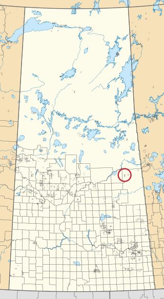
The Rural Municipality of Saltcoats No. 213 is a rural municipality (RM) in the Canadian province of Saskatchewan within Census Division No. 5 and SARM Division No. 1. It is located in the east-central portion of the province.
Carrot River 29A is an Indian reserve of the Red Earth Cree Nation in Saskatchewan. It is 48 miles east of Nipawin. In the 2016 Canadian Census, it recorded a population of 829 living in 127 of its 127 total private dwellings. In the same year, its Community Well-Being index was calculated at 40 of 100, compared to 58.4 for the average First Nations community and 77.5 for the average non-Indigenous community.

Fishing Lake 89 is an Indian reserve of the Fishing Lake First Nation in Saskatchewan. It is 119 kilometres (74 mi) north of Fort Qu'Appelle. In the 2016 Canadian Census, it recorded a population of 406 living in 128 of its 161 total private dwellings. In the same year, its Community Well-Being index was calculated at 54 of 100, compared to 58.4 for the average First Nations community and 77.5 for the average non-Indigenous community.

Cote 64 is an Indian reserve of the Cote First Nation in Saskatchewan. It is 16 kilometres (9.9 mi) west of the Manitoba border. In the 2016 Canadian Census, it recorded a population of 748 living in 220 of its 269 total private dwellings. In the same year, its Community Well-Being index was calculated at 51 of 100, compared to 58.4 for the average First Nations community and 77.5 for the average non-Indigenous community.

Cowessess 73 is an Indian reserve of the Cowessess First Nation in Saskatchewan. It is 13 kilometres (8.1 mi) north-west of Broadview. In the 2016 Canadian Census, it recorded a population of 540 living in 190 of its 214 total private dwellings. In the same year, its Community Well-Being index was calculated at 63 of 100, compared to 58.4 for the average First Nations community and 77.5 for the average non-Indigenous community.

Cumberland House Cree Nation 20 is an Indian reserve of the Cumberland House Cree Nation in Saskatchewan. The reserve is on Cumberland Island in the Saskatchewan River Delta, about 96 kilometres (60 mi) south-west of Flin Flon.

Day Star 87 is an Indian reserve of the Day Star First Nation in Saskatchewan. It is 87 kilometres (54 mi) north-west of Fort Qu'Appelle. In the 2016 Canadian Census, it recorded a population of 148 living in 42 of its 62 total private dwellings. In the same year, its Community Well-Being index was calculated at 65 of 100, compared to 58.4 for the average First Nations community and 77.5 for the average non-Indigenous community.

Kahkewistahaw 72 is an Indian reserve of the Kahkewistahaw First Nation in Saskatchewan. It is about 13 kilometres (8.1 mi) north of Broadview. In the 2016 Canadian Census, it recorded a population of 502 living in 146 of its 184 total private dwellings. In the same year, its Community Well-Being index was calculated at 58 of 100, compared to 58.4 for the average First Nations community and 77.5 for the average non-Indigenous community.

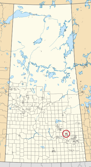
Keeseekoose 66 is an Indian reserve of the Keeseekoose First Nation in Saskatchewan. It is about 16 kilometres (9.9 mi) north of Kamsack. In the 2016 Canadian Census, it recorded a population of 491 living in 135 of its 155 total private dwellings. In the same year, its Community Well-Being index was calculated at 50 of 100, compared to 58.4 for the average First Nations community and 77.5 for the average non-Indigenous community.

Keeseekoose 66-CA-04 is an Indian reserve of the Keeseekoose First Nation in Saskatchewan. It is about 39 kilometres (24 mi) east of Yorkton. In the 2016 Canadian Census, it recorded a population of 0 living in 0 of its 1 total private dwellings.

Keeseekoose 66-KE-04 is an Indian reserve of the Keeseekoose First Nation in Saskatchewan. It is about 15 kilometres (9.3 mi) east of Canora. In the 2016 Canadian Census, it was recorded as uninhabited.

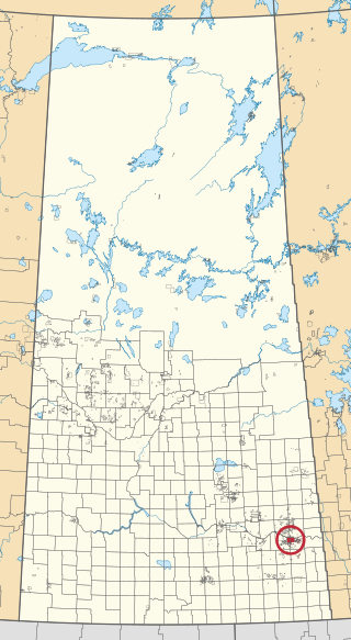
Keeseekoose 66-KE-05 is an Indian reserve of the Keeseekoose First Nation in Saskatchewan. It is about 19 kilometres (12 mi) north-east of Canora. In the 2016 Canadian Census, it recorded a population of 5 living in 1 of its 2 total private dwellings.
Little Black Bear 84 is an Indian reserve of the Little Black Bear First Nation in Saskatchewan. It is about 19 kilometres (12 mi) east of Fort Qu'Appelle. In the 2016 Canadian Census, it recorded a population of 137 living in 34 of its 43 total private dwellings. In the same year, its Community Well-Being index was calculated at 51 of 100, compared to 58.4 for the average First Nations community and 77.5 for the average non-Indigenous community.

Ministikwan 161 is an Indian reserve of the Ministikwan Lake Cree Nation in Saskatchewan. It is 161 kilometres northwest of North Battleford. In the 2016 Canadian Census, it recorded a population of 624 living in 128 of its 150 total private dwellings. In the same year, its Community Well-Being index was calculated at 38 of 100, compared to 58.4 for the average First Nations community and 77.5 for the average non-Indigenous community.
Ochapowace 71 is an Indian reserve of the Ochapowace Nation in Saskatchewan. It is 8 kilometres northeast of Broadview. In the 2016 Canadian Census, it recorded a population of 426 living in 126 of its 138 total private dwellings. In the same year, its Community Well-Being index was calculated at 61 of 100, compared to 58.4 for the average First Nations community and 77.5 for the average non-Indigenous community.

Ochapowace 71-51 is an Indian reserve of the Ochapowace Nation in Saskatchewan. It is 6 kilometres south of Atwater. In the 2016 Canadian Census, it recorded a population of 0 living in 0 of its 0 total private dwellings.

Pelican Narrows 184B is an Indian reserve of the Peter Ballantyne Cree Nation in Saskatchewan. It is 80 kilometres northeast of Flin Flon. In the 2016 Canadian Census, it recorded a population of 1869 living in 327 of its 350 total private dwellings. In the same year, its Community Well-Being index was calculated at 34 of 100, compared to 58.4 for the average First Nations community and 77.5 for the average non-Indigenous community.

The Key 65 is an Indian reserve of The Key First Nation in Saskatchewan, Canada. It is 26 kilometres northwest of Kamsack. In the 2016 Canadian Census, it recorded a population of 143 living in 46 of its 58 total private dwellings. In the same year, its Community Well-Being index was calculated at 60 of 100, compared to 58.4 for the average First Nations community and 77.5 for the average non-Indigenous community.

