
The Rural Municipality of Aberdeen No. 373 is a rural municipality (RM) in the Canadian province of Saskatchewan within Census Division No. 15 and SARM Division No. 5. It is located on the South Saskatchewan River.

The Rural Municipality of Corman Park No. 344 is a rural municipality (RM) in the Canadian province of Saskatchewan within Census Division No. 11 and SARM Division No. 5. Located in the central portion of the province, the RM surrounds the City of Saskatoon.

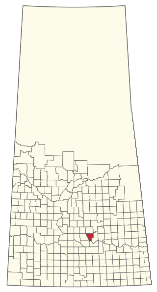
The Rural Municipality of Arm River No. 252 is a rural municipality (RM) in the Canadian province of Saskatchewan within Census Division No. 11 and SARM Division No. 5. It is located along Highway 11 between Saskatoon and Regina.
The Rural Municipality of Abernethy No. 186 is a rural municipality (RM) in the Canadian province of Saskatchewan within Census Division No. 6 and SARM Division No. 1. It is located on the Qu'Appelle River.

The Rural Municipality of Eagle Creek No. 376 is a rural municipality (RM) in the Canadian province of Saskatchewan within Census Division No. 12 and SARM Division No. 5. It is located west of the City of Saskatoon.

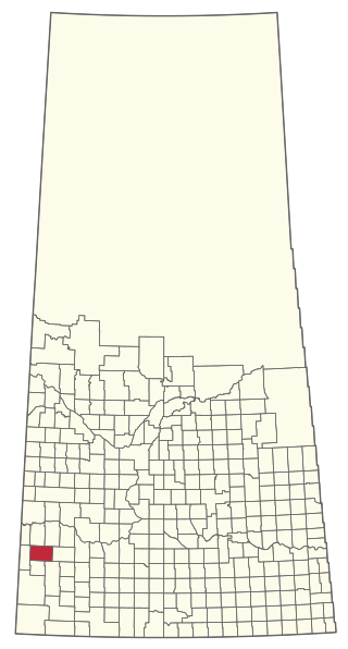
The Rural Municipality of Eye Hill No. 382 is a rural municipality (RM) in the Canadian province of Saskatchewan within Census Division No. 13 and SARM Division No. 6. It is located in the west-central portion of the province adjacent to the Alberta boundary.

The Rural Municipality of Milton No. 292 is a rural municipality (RM) in the Canadian province of Saskatchewan within Census Division No. 13 and SARM Division No. 6. Located in the west-central portion of the province, it is adjacent to the Alberta boundary.
The Rural Municipality of Fox Valley No. 171 is a rural municipality (RM) in the Canadian province of Saskatchewan within Census Division No. 8 and SARM Division No. 3.
The Rural Municipality of McKillop No. 220 is a rural municipality (RM) in the Canadian province of Saskatchewan within Census Division No. 6 and SARM Division No. 2.

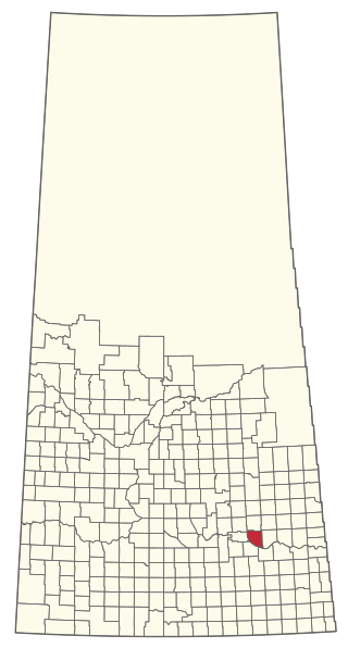
The Rural Municipality of Rosedale No. 283 is a rural municipality (RM) in the Canadian province of Saskatchewan within Census Division No. 11 and SARM Division No. 5. It is located in the central portion of the province along Highway 11 between Saskatoon and Regina.

The Rural Municipality of Leroy No. 339 is a rural municipality (RM) in the Canadian province of Saskatchewan within Census Division No. 10 and SARM Division No. 5. It is located east of Saskatoon.
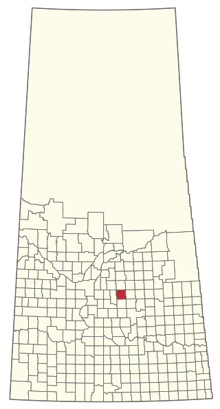
The Rural Municipality of Wolverine No. 340 is a rural municipality (RM) in the Canadian province of Saskatchewan within Census Division No. 11 and SARM Division No. 5. It is located in the central portion of the province east of Saskatoon.

The Rural Municipality of Humboldt No. 370 is a rural municipality (RM) in the Canadian province of Saskatchewan within Census Division No. 15 and SARM Division No. 5. Located in the central portion of the province, it is along Highway 5 and Highway 20 north of Regina and east of Saskatoon.

The Rural Municipality of Birch Hills No. 460 is a rural municipality (RM) in the Canadian province of Saskatchewan within Census Division No. 15 and SARM Division No. 5. It is located in the north-central portion of the province on Highway 3 southeast of Prince Albert and north of Saskatoon.

Vanscoy is a village in the Canadian province of Saskatchewan within the Rural Municipality of Vanscoy No. 345 and Census Division No. 12. Vanscoy is located on Highway 7 near Highway 762 in central Saskatchewan, 29 km southwest of the City of Saskatoon. Rice Lake is to the west, Goose Lake is to the north, and Pike Lake and Pike Lake Provincial Park are to the east. One of the largest economic industries near Vanscoy is Agrium Vanscoy Potash Operations which produces 1,790,000 metric tonnes of potash a year. Community facilities include a circle hall, ice rink, curling rink and ball diamond.
The Rural Municipality of Lawtonia No. 135 is a rural municipality (RM) in the Canadian province of Saskatchewan within Census Division No. 7 and SARM Division No. 3.

The Rural Municipality of Fish Creek No. 402 is a rural municipality (RM) in the Canadian province of Saskatchewan within Census Division No. 15 and SARM Division No. 5.

The Rural Municipality of Coteau No. 255 is a rural municipality (RM) in the Canadian province of Saskatchewan within Census Division No. 7 and SARM Division No. 3.

The Rural Municipality of Montrose No. 315 is a rural municipality (RM) in the Canadian province of Saskatchewan within Census Division No. 12 and SARM Division No. 5.

The Rural Municipality of Pleasant Valley No. 288 is a rural municipality (RM) in the Canadian province of Saskatchewan within Census Division No. 12 and SARM Division No. 6.

