
The Rural Municipality of Blucher No. 343 is a rural municipality (RM) in the Canadian province of Saskatchewan within Census Division No. 11 and SARM Division No. 5. It is located in the north-central portion of the province on the South Saskatchewan River.
Russell is an unincorporated urban community in the Municipality of Russell – Binscarth, Manitoba.
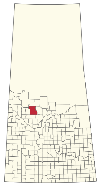
The Rural Municipality of Spiritwood No. 496 is a rural municipality (RM) in the Canadian province of Saskatchewan within Census Division No. 16 and SARM Division No. 6. Located in the north-central portion of the province, it is west of the City of Prince Albert.

Highway 39 is a provincial, paved, highway located in the southern portion of the Canadian province of Saskatchewan connecting North Portal and Moose Jaw in the north. This is a primary Saskatchewan highway maintained by the provincial and national governments and providing a major trucking and tourism route between the United States via Portal, Burke County, North Dakota, and North Portal, Saskatchewan. On July 3, 2000, Highways and Transportation Minister Maynard Sonntag officiated at the ribbon cutting ceremony opening the new duty-free shop and the twinned highway at Saskatchewan's busiest border crossing. Highway 39 is one of Canada's busiest highways, facilitating transport for $6 billion in trade goods via approximately 100,000 trucks over the year. The entire length of highway 39 is paved. The CanAm Highway comprises Saskatchewan Highways Hwy 35, Hwy 39, Hwy 6, Hwy 3, as well as Hwy 2. 44.3 miles (71.3 km) of Saskatchewan Highway 39 contribute to the CanAm Highway between Weyburn and Corinne. Highway 39 is divided or twinned in two areas at North Portal as well as north of Weyburn for 1.7 kilometres (1.1 mi). The junction of Hwy 39 with the Trans–Canada divided four-lane highway is done via a "Parclo" or partial cloverleaf interchange.

Belle Plaine is a village in the Canadian province of Saskatchewan within the Rural Municipality of Pense No. 160 and Census Division No. 6. Belle Plaine is located on Highway 1, 21 kilometres east of the City of Moose Jaw in south-central Saskatchewan. Buffalo Pound Provincial Park and Regina Beach are located near Belle Plaine.

Vanscoy is a village in the Canadian province of Saskatchewan within the Rural Municipality of Vanscoy No. 345 and Census Division No. 12. Vanscoy is located on Highway 7 near Highway 762 in central Saskatchewan, 29 km southwest of the City of Saskatoon. Rice Lake is to the west, Goose Lake is to the north, and Pike Lake and Pike Lake Provincial Park are to the east. One of the largest economic industries near Vanscoy is Agrium Vanscoy Potash Operations which produces 1,790,000 metric tonnes of potash a year. Community facilities include a circle hall, ice rink, curling rink and ball diamond.

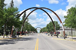
Colonsay is a town in the Rural Municipality of Colonsay No. 342, in the Canadian province of Saskatchewan. Colonsay is located on Highway 16 running east–west in central Saskatchewan near the intersection with Highway 2.
Churchbridge is a town in the province of Saskatchewan, Canada, located at the junction of the Yellowhead Highway, and Highway 80. Churchbridge is a part of the rural municipality of Churchbridge 211, which is located within Saskatchewan Association of Rural Municipalities (SARM) Division No. 1 and census division Number 5.

Bredenbury is a town in the rural municipality of Saltcoats No. 213, in the Canadian province of Saskatchewan. Bredenbury is located on Highway 16 in eastern Saskatchewan. As of the 2016 Canadian Census, the population of Bredenbury was 372. The main industries in the area are farming and potash mining near Esterhazy. The community is known in the area for its enthusiastic Christmas light displays which have won national awards.
Grayson is a village in the Canadian province of Saskatchewan within the Rural Municipality of Grayson No. 184 and Census Division No. 5.
Canpotex, short for Canadian Potash Exporters, is a Canadian potash exporting and marketing firm, incorporated in 1970 and operating since 1972. Based in Saskatchewan, Canpotex manages the entire Saskatchewan potash exporting industry, including transportation and delivery.
Smiley is a village in the Canadian province of Saskatchewan within the Rural Municipality of Prairiedale No. 321 and Census Division No. 13. The village is located approximately 20 km northwest of the town of Kindersley at the intersection of Highway 307 and Highway 772. The Grand Trunk Pacific Railway was completed in 1913, bringing an economic boom to the village's early years. On April 26, 1987 the Dodsland subdivision between Dodsland and Smiley was transferred to the Canadian Pacific Railway. Due to the close proximity to major grain centres such as Kindersley, CPR put the line up for abandonment and was granted permission to remove the track by the Canadian Transportation Agency on October 29, 1997.

Young is a village in the Canadian province of Saskatchewan within the Rural Municipality of Morris No. 312. The economy is dominated by local agriculture and the nearby Mosaic Potash mine.

The Rural Municipality of Pleasant Valley No. 288 is a rural municipality (RM) in the Canadian province of Saskatchewan within Census Division No. 12 and SARM Division No. 6.

The Rural Municipality of Rosemount No. 378 is a rural municipality (RM) in the Canadian province of Saskatchewan within Census Division No. 12 and SARM Division No. 6.
Indi Lake is a man-made lake in central Saskatchewan, Canada, south of Saskatoon in the Rural Municipality of Dundurn No. 314. The lake was created for irrigation and recreation in 1967 by a dam located at its south end. The lake is part of a greater irrigation and aqueduct system built in the 1960s in Saskatchewan and was named after Indi, an unincorporated railway point nearby on the Canadian National Railway (CNR).

Wartime is an unincorporated community and former hamlet, within the Rural Municipality of Monet No. 257, Saskatchewan, Canada. The community is located along Highway 44 approximately 13 km west of Elrose along Canadian National Railway's Elrose sub-division track. The community once boasted a train station built in 1914 which was demolished in 1978, two grain elevators; a Saskatchewan Wheat Pool and a Federal elevator as well as a wooden water tank. The elevators have disappeared but the water tower is still standing and in use.

Cando is a hamlet in Rosemount Rural Municipality No. 378, Saskatchewan, Canada. In 2006 the village had a population of 68 people. It previously held the status of village until December 31, 2005. The hamlet is located 48 km south of the City of North Battleford on highway 4. The community was served by Canadian National Railway's Porter Subdivision. The rail line was originally built by the Grand Truck Pacific from Oban to Battleford. The community is situated along the remains of the historic Swift Current-Battleford Trail. The portion of the line from Battleford to Cando was closed in 1974, leaving the portion to Cando from Oban. Once the elevator at Cando closed the remainder of the line was abandoned in the late 1980s.
