A grain elevator is a facility designed to stockpile or store grain. In the grain trade, the term "grain elevator" also describes a tower containing a bucket elevator or a pneumatic conveyor, which scoops up grain from a lower level and deposits it in a silo or other storage facility.

Prince Albert is the third-largest city in Saskatchewan, Canada, after Saskatoon and Regina. It is situated near the centre of the province on the banks of the North Saskatchewan River. The city is known as the "Gateway to the North" because it is the last major centre along the route to the resources of northern Saskatchewan. Prince Albert National Park is located 51 km (32 mi) north of the city and contains a wealth of lakes, forest, and wildlife. The city itself is located in a transition zone between the aspen parkland and boreal forest biomes. Prince Albert is surrounded by the Rural Municipality of Prince Albert No. 461, of which it is the seat, but is politically separate.

Melville is a city in the east-central portion of Saskatchewan, Canada. The city is about 145 kilometres (90 mi) northeast of the provincial capital of Regina and 45 kilometres (28 mi) southwest of Yorkton. Melville is bordered by the rural municipalities of Cana No. 214 and Stanley No. 215. Its population at the 2016 census was 4,562, making it Saskatchewan's smallest city. It is also home of hockey's Melville Millionaires, who compete in the Saskatchewan Junior Hockey League, and baseball's Melville Millionaires, who competed in the Western Canadian Baseball League until 2019.

Rosetown is a town in the Canadian province of Saskatchewan, at the junction of provincial Highway 7 and Highway 4, approximately 115 kilometres southwest of Saskatoon. The town's motto, "The Heart of the Wheat Belt" reflects its history of being a farming community. It is within the Rural Municipality of St. Andrews No. 287.

Girvin is a former village of 20 people in Saskatchewan, Canada. It is located midway between Regina and Saskatoon on Highway 11 between the towns of Davidson and Craik. The village was formally dissolved in 2005; its remaining population is now counted as part of the rural municipality of Arm River.

Harris is a village in the Canadian province of Saskatchewan within the Rural Municipality of Harris No. 316 and Census Division No. 12. It was the site of the Great Ruby Hoax in 1914. Harris was named for Richard Elford Harris, an early settler to the area.
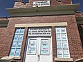
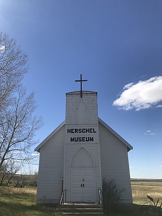
Herschel is a special service area in the Canadian province of Saskatchewan. It is the seat of the Rural Municipality of Mountain View No. 318 and held village status prior to December 31, 2006. The population was 30 people in 2016. The community is located 37 km northwest of the town of Rosetown at the intersection of Highway 31 and Highway 656, along a now abandoned section of the Kerrobert-Rosetown Canadian Pacific Railway line. Herschel is the home of the Ancient Echoes Interpretive Centre. The Vancouver-based backpack manufacturer Herschel Supply Co., founded by Lyndon and Jamie Cormack in 2009, adopted the name of Herschel, the town where three generations of their family grew up.

Bents is an unincorporated community in Marriott No. 317, Saskatchewan, Canada. Prior to the town founding, the area was referred to as Piche. Bents took its name from Longniddry Bents in Scotland. Its derelict wooden grain elevator was once the subject of a National Geographic photograph. The remnants of the town are now located on private property.
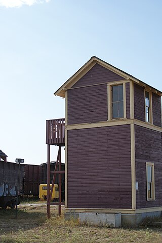
Oban is an unincorporated area administered by the rural municipality of Biggar No. 347, in the Canadian province of Saskatchewan. Oban is located on Saskatchewan Highway 14 in western Saskatchewan. The closest town is Biggar to the southeast. Biggar railway station is a divisional point for the Canadian National Railway (CNR). Oban had the last provincial interlocking tower at the Canadian National Railway and Canadian Pacific Railway level crossing, which was constructed in 1910 and closed in 1990.

Fiske is a hamlet in Pleasant Valley Rural Municipality No. 288, Saskatchewan, Canada. Listed as a designated place by Statistics Canada, the hamlet had a population of 65 in the Canada 2016 Census. Fiske is located approximately 53.7 kilometres (33.4 mi) east of Kindersley and 30.6 kilometres (19.0 mi) west of Rosetown on Highway 7.
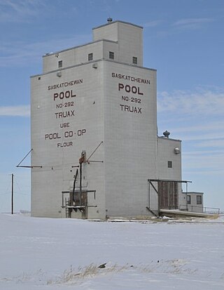
Truax is an unincorporated community in the Rural Municipality of Elmsthorpe No. 100, Saskatchewan, Canada. It held village status prior to December 30, 1970. Truax is located 80 km (50 mi) southwest of Regina and approximately 75 km (47 mi) southeast of Moose Jaw.
Ruthilda is a former village in the Rural Municipality of Grandview No. 349, Saskatchewan, Canada. It dissolved from village status to become part of the Rural Municipality of Grandview No. 349 on December 31, 2013. Ruthilda is located about 5 km south of Highway 51 approximately 30 km southwest of the Town of Biggar.

Bromhead is an unincorporated community and ghost town in Souris Valley Rural Municipality No. 7, Saskatchewan, Canada. The community is approximately 5 km (3.1 mi) north of Highway 18 and 45 km (28 mi) west of the City of Estevan.

The Rural Municipality of Moose Mountain No. 63 is a rural municipality (RM) in the Canadian province of Saskatchewan within Census Division No. 1 and SARM Division No. 1. It is located in the south-east portion of the province.
The Rural Municipality of Mountain View No. 318 is a rural municipality (RM) in the Canadian province of Saskatchewan within Census Division No. 12 and SARM Division No. 6.

The Rural Municipality of Pleasant Valley No. 288 is a rural municipality (RM) in the Canadian province of Saskatchewan within Census Division No. 12 and SARM Division No. 6.

Wartime is an unincorporated community and former hamlet, within the Rural Municipality of Monet No. 257, Saskatchewan, Canada. The community is located along Highway 44 approximately 13 km west of Elrose along Canadian National Railway's Elrose sub-division track. The community once boasted a train station built in 1914 which was demolished in 1978, two grain elevators; a Saskatchewan Wheat Pool and a Federal elevator as well as a wooden water tank. The elevators have disappeared but the water tower is still standing and in use.

Horizon, located on the south side of Channel Lake, is a hamlet in Bengough Rural Municipality No. 40, Saskatchewan, Canada. It previously held the status of village until December 31, 1973. The hamlet is located 60 km (37 mi) east of the Town of Assiniboia on highway 13.
Phippen, Saskatchewan is an unincorporated community, school site, and elevator site on the Canadian Pacific line running east–west between Wilkie, Saskatchewan and Unity, Saskatchewan.

Penkill is an unincorporated hamlet within the Rural Municipality of Snipe Lake No. 259, Saskatchewan, Canada. The community is located approximately 20 km north of the town of Eston, 8 km east of Highway 30 and 4.81 km north of Highway 752 on Range Road 194. Very little remains of the former community, since the railway was pulled up. All that is left is a grain elevator, over grown streets and a couple houses.