
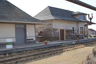
D'Arcy is an unincorporated community in Rural Municipality of Pleasant Valley No. 288 in western-central Saskatchewan, Canada. The post office started out with the name D'Arcy Station in 1911 in the Federal Electoral District of Kindersley. Along with McGee, Saskatchewan, the town is named after the Father of Confederation, D'Arcy McGee.
Tramping Lake is a village in the Canadian province of Saskatchewan within the Rural Municipality of Tramping Lake No. 380 and Census Division No. 13. The village gets its name from nearby Tramping Lake.
Lake Lenore is a village in the Canadian province of Saskatchewan within the Rural Municipality of Lake Lenore No. 399 and Census Division No. 15. The village is located 144.6 km northeast of the City of Saskatoon. Outside of the village is a lake that shares its name, Lake Lenore, renowned for its fishing activity as well the Rural Municipality of Lake Lenore No. 399 to the north. Lake Lenore possesses a fully operational school, Co-op Grocery and Agro Service Station and also contains a Credit Union and Public Library.
Mistatim is a village in the Canadian province of Saskatchewan within the Rural Municipality of Bjorkdale No. 426 and Census Division No. 14. It is just to the north of Highway 3. Mistatim is 35 miles (56 km) east of the Town of Tisdale and 40 miles (64 km) west of Hudson Bay. The Greenwater Lake Provincial Park is 30 miles (48 km) to the south.

Penzance is a special service area in the Rural Municipality of Sarnia No. 221, in the Canadian province of Saskatchewan. It held village status prior to January 31, 2008. The population was 41 people in 2001. The community is located 88 km north of the City of Moose Jaw on Highway 2. Penzance was named after the original Penzance, in Cornwall, England.
Fielding, Saskatchewan is an unincorporated area in the rural municipality of Mayfield No. 406, Saskatchewan, in the Canadian province of Saskatchewan. Fielding is located on Saskatchewan Highway 16, the Yellowhead in north western Saskatchewan. Fielding post office first opened in 1905 at the legal land description of Sec.18, Twp.41, R.11, W3. The population is smaller than a hamlet, and is counted within the Mayfield No. 406, Saskatchewan. Fielding is located just south east of North Battleford, Saskatchewan. Fielding is located within 11 kilometres (6.8 mi) of Glenburn Regional Park and within 9 kilometres (5.6 mi) of the Radisson Lake Game Preserve.

Sheho is a village in the Canadian province of Saskatchewan within the Rural Municipality of Viscount No. 341 and Census Division No. 9. Sheho is located on Saskatchewan Highway 16, the Yellowhead, in southeast Saskatchewan between Foam Lake to the west and the City of Yorkton to the east. Sheho Lake post office first opened in 1891 at the legal land description of Sec.28, Twp.30, R.9, W2 before moving slightly and changing name to Sheho.
Insinger, Saskatchewan is an unincorporated area in the rural municipality of Insinger No. 275, Saskatchewan, in the Canadian province of Saskatchewan. Insinger is located on Saskatchewan Highway 16, the Yellowhead in south eastern Saskatchewan. Lawrie post office first opened in 1898 at the legal land description of Sec.6, Twp.29, R.7, W2. It changed names in 1907 to Insinger and moved to Sec.21, Twp.29, R.8, W2. The population is smaller than a hamlet, and is counted within the Insinger No. 275, Saskatchewan, however it is still listed as a village at Geonames. Insinger is located between Yorkton and Foam Lake. Insinger is located within 14 kilometres (8.7 mi) of Whitesand Regional Park.

Scotsguard is an unincorporated community within the Rural Municipality of Bone Creek No. 108, Saskatchewan, Canada. The community is located on Highway 13, also known as the historic Red Coat Trail, about 10 km northeast of the town of Shaunavon.
Brisbin is an unincorporated community within the rural municipality of Harris.
Argo is an unincorporated community or a siding administered by the rural municipality of Biggar No. 347, in the Canadian province of Saskatchewan. Argo was located on the Dodsland Branch of the Canadian National Railway between Biggar and Duperow. The closest town is Biggar to the northeast. Biggar railway station is a divisional point for the Canadian National Railway (CNR).
Delmas is a hamlet in Battle River Rural Municipality No. 438, Saskatchewan, Canada. Listed as a designated place by Statistics Canada, the hamlet had a population of 128 in the Canada 2016 Census. The hamlet is located approximately 32.6 kilometres (20.3 mi) west of North Battleford on Highway 16.
Shackleton is a special service area in the Rural Municipality of Miry Creek No. 229, Saskatchewan, Canada. It previously held the status of village until December 31, 2013. The community is located 81 km (50 mi) northwest of the City of Swift Current on Highway 32.
Birch Lake is an unincorporated community in Medstead Rural Municipality No. 497, Saskatchewan, Canada. The community is located about 10 km (6.2 mi) north of Highway 3 on Range Road 145, approximately 20 km (12 mi) north of Medstead.
Burnham is an unincorporated community in Coulee Rural Municipality No. 136, Saskatchewan, Canada. The community is located on Highway 628, approximately 9 km (5.6 mi) north of Highway 363 and 15 km (9.3 mi) south of Swift Current.
Illerbrun is an unincorporated community within the Rural Municipality of Bone Creek No. 108, Saskatchewan, Canada. Located approximately 10 km east of Highway 37, 92.5 km southwest of Swift Current.
Cardross, originally named Grace, is an unincorporated hamlet in Terrell Rural Municipality No. 101, Saskatchewan, Canada. The hamlet is located approximately 45 km north-east of Assiniboia on Township road 102 & Range road 274.
Chipperfield is a hamlet in Monet Rural Municipality No. 257, Saskatchewan, Canada. The hamlet is located at the junction of Highway 752 and Range road 170 approximately 50 km south-west of the Town of Rosetown, only 170 km south-west of the City of Saskatoon.
Thackeray, Saskatchewan is an unincorporated community, school site, and elevator site on the Canadian Pacific line running northwest of Wilkie, Saskatchewan.

Smuts is an unincorporated community within the Rural Municipality of Grant No. 372, in the province of Saskatchewan, Canada. Smuts is located west of Highway 41 north of Vonda,.
