Gallery
Points of interest in Donavon, Saskatchewan and area.
 Knox United Church memorial near Donavon, Saskatchewan
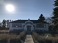 Former school in Donavon, Saskatchewan
 Donavon, Saskatchewan school sign
Donavon is a hamlet in Montrose Rural Municipality 315, Saskatchewan, Canada. The hamlet is located southwest of Saskatoon along Highway 45 and Canadian National Railway, Delisle-Tichfield Junction stub.
The name is a combination of the Don River (Ontario) and the Avon River (Ontario). [1]
Points of interest in Donavon, Saskatchewan and area.


Subdivisions of Saskatchewan | |
|---|---|
| Subdivisions | |
| Communities | |
| Cities | |
| Topics | |
51°47′46″N107°07′37″W / 51.79611°N 107.12694°W
| | This Saskatchewan location article is a stub. You can help Wikipedia by expanding it. |