Biggar is a town in central Saskatchewan, Canada. It is located on Highway 14, 93 kilometres (58 mi) west of Saskatoon, the province's most populous city.

The Rural Municipality of Corman Park No. 344 is a rural municipality (RM) in the Canadian province of Saskatchewan within Census Division No. 11 and SARM Division No. 5. Located in the central portion of the province, the RM surrounds the City of Saskatoon.

Admiral is a special service area within the Rural Municipality of Wise Creek No. 77 in Saskatchewan, Canada. Originally incorporated as a village in 1914, it relinquished its status when it dissolved on August 17, 2006.
The Rural Municipality of Dundurn No. 314 is a rural municipality (RM) in the Canadian province of Saskatchewan within Census Division No. 11 and SARM Division No. 5. It is located in the north-central portion of the province along the South Saskatchewan River and surrounds the Town of Dundurn.

Division No. 12 is one of the eighteen census divisions in the province of Saskatchewan, Canada, as defined by Statistics Canada. It is located in the west-central part of the province. The most populous community in this division is Battleford.

The Rural Municipality of Bone Creek No. 108 is a rural municipality (RM) in the Canadian province of Saskatchewan within Census Division No. 4 and SARM Division No. 3. It is located in the southwest portion of the province.

Leroy is a town in the province of Saskatchewan, Canada.
Highgate, Saskatchewan is an unincorporated area in the rural municipality of Battle River No. 438, Saskatchewan, in the Canadian province of Saskatchewan. Highgate is located on Saskatchewan Highway 16, the Yellowhead in north western Saskatchewan. Highgate siding, a railroad siding and post office first opened in 1919 at the legal land description of Sec.17, Twp.45, R.17, W3. The population is smaller than a hamlet, and is counted within the RM. Highgate is located just north west of North Battleford, Saskatchewan.

The Rural Municipality of Mayfield No. 406 is a rural municipality (RM) in the Canadian province of Saskatchewan within Census Division No. 16 and SARM Division No. 6.

The Rural Municipality of Churchbridge No. 211 is a rural municipality (RM) in the Canadian province of Saskatchewan within Census Division No. 5 and SARM Division No. 1. It is located in the east-central portion of the province.
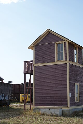
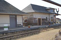
Oban is an unincorporated area administered by the rural municipality of Biggar No. 347, in the Canadian province of Saskatchewan. Oban is located on Saskatchewan Highway 14 in western Saskatchewan. The closest town is Biggar to the southeast. Biggar railway station is a divisional point for the Canadian National Railway (CNR). Oban had the last provincial interlocking tower at the Canadian National Railway and Canadian Pacific Railway level crossing, which was constructed in 1910 and closed in 1990.
Delmas is a hamlet in Battle River Rural Municipality No. 438, Saskatchewan, Canada. Listed as a designated place by Statistics Canada, the hamlet had a population of 128 in the Canada 2016 Census. The hamlet is located approximately 32.6 kilometres (20.3 mi) west of North Battleford on Highway 16.

The Rural Municipality of Moose Mountain No. 63 is a rural municipality (RM) in the Canadian province of Saskatchewan within Census Division No. 1 and SARM Division No. 1. It is located in the south-east portion of the province.

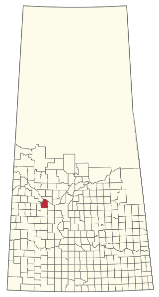
The Rural Municipality of Biggar No. 347 is a rural municipality (RM) in the Canadian province of Saskatchewan within Census Division No. 12 and SARM Division No. 6.
The Rural Municipality of Glenside No. 377 is a rural municipality (RM) in the Canadian province of Saskatchewan within Census Division No. 12 and SARM Division No. 6.

The Rural Municipality of Grandview No. 349 is a rural municipality (RM) in the Canadian province of Saskatchewan within Census Division No. 13 and SARM Division No. 6.

The Rural Municipality of Pleasant Valley No. 288 is a rural municipality (RM) in the Canadian province of Saskatchewan within Census Division No. 12 and SARM Division No. 6.

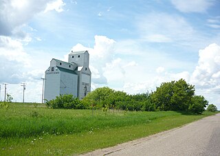
Cando is a hamlet in Rosemount Rural Municipality No. 378, Saskatchewan, Canada. In 2006 the village had a population of 68 people. It previously held the status of village until December 31, 2005. The hamlet is located 48 km south of the City of North Battleford on highway 4. The community was served by Canadian National Railway's Porter Subdivision. The rail line was originally built by the Grand Truck Pacific from Oban to Battleford. The community is situated along the remains of the historic Swift Current-Battleford Trail. The portion of the line from Battleford to Cando was closed in 1974, leaving the portion to Cando from Oban. Once the elevator at Cando closed the remainder of the line was abandoned in the late 1980s.
The North Battleford Crown Colony is an unincorporated community within the Rural Municipality of North Battleford No. 437 in Saskatchewan, Canada that is designated a census subdivision by Statistics Canada. It is adjacent to the City of North Battleford and is home to the Saskatchewan Hospital North Battleford.