Rural Municipality of Last Mountain Valley No. 250

Last updated

Last Mountain Valley No. 250
Rural Municipality of Last Mountain Valley No. 250
SK RM 250 Last Mountain Valley.svg
Location of the RM of Last Mountain Valley No. 250 in Saskatchewan
Coordinates: 51°15′32″N105°12′36″W / 51.259°N 105.210°W / 51.259; -105.210 [1]
Country Canada
Province Saskatchewan
Census division 11
SARM division 5
Formed [2] December 13, 1909
Government
[3]
   Reeve Allan Magel
  Governing bodyRM of Last Mountain Valley No. 250 Council
  AdministratorKelly Holbrook
  Office location Govan
Area
 (2016) [4]
  Land871.17 km2 (336.36 sq mi)
Population
 (2016) [4]
  Total275
  Density0.3/km2 (0.8/sq mi)
Time zone CST
  Summer (DST) CST
Area code(s) 306 and 639

The Rural Municipality of Last Mountain Valley No. 250 (2016 population: 275) is a rural municipality (RM) in the Canadian province of Saskatchewan within Census Division No. 11 and SARM Division No. 5.

Contents

History

The RM of Last Mountain Valley No. 250 incorporated as a rural municipality on December 13, 1909. [2]

Arlington Beach House

Arlington Beach House was one of the first hotels built in Saskatchewan and was one of the first buildings constructed along Last Mountain Lake. This once luxury hotel was built in 1910 at Arlington Beach, Saskatchewan by the William Pearson Land Company [5] as their centre of operations in Saskatchewan. It was a popular vacation destination for people all across central Saskatchewan.

Geography

Communities and localities

The following urban municipalities are surrounded by the RM.

Towns
Villages

The following unincorporated communities are within the RM.

Organized hamlets [6]
Localities

Last Mountain

Last Mountain [7] is a hilly plateau mostly within the south-east corner of the RM of Last Mountain Valley. A portion of the southern slope is in the RM of McKillop and a portion of the eastern slope is in the RM of Longlaketon. Duval is the closest community, directly to the west, and Strasbourg, to the south-west, is the closest town.

The Legend of Last Mountain is a Plains Indians legend on the creation of Last Mountain. It states that after the Great Chief finished building all the hills on the prairies there was left-over dirt, which he used to create Last Mountain. That was the last thing he built and the neighbouring lake, Last Mountain Lake, was the last lake to be filled.

When the Great Chief of the world completed the building of all the hills, he found he had a little material left over and he looked about to see where he should put it. He saw that the prairie lay smooth and level and for many days journey, unbroken by mountain, lake, or stream.

"What fitter place than this to lay good soil?" he said, and in the midst of the prairie he built a mound with what dirt remained and, scooping a hollow with his hand, he made the water left over from the rivers a long lake. And he breathed on it so that the grass and trees grew, and the birds and buffalo came to rest in the shade.

All that was wanting was a name, so the Great Chief lifted up his voice and summoned all his braves and they came on wings like the eagle, greeting their chief with a shout like thunder booming among the hills. Then from their ranks steeped Cheewana, daughter of the great chieftain, beautiful as the summer morning, wise as a beaver and she bent at his feet.

And she said, "Because this mountain was the last of thy making and this lake is the last of thy filling, I offer you for the one the name of Last Mountain and for the other that of Last Mountain Lake." [8]

That legend was first published by William Pearson Publishing Company Ltd. Of Winnipeg c. 1911. It was an exert from a pamphlet called "Last Mountain Lake Saskatchewan's Summer Resort".

Last Mountain Regional Park

Last Mountain Regional Park ( 51°21′05″N105°13′02″W / 51.3514°N 105.2172°W / 51.3514; -105.2172 ) [9] is a regional park at the far north-west corner of the RM within the Last Mountain Lake Bird Sanctuary, along the eastern shore of Last Mountain Lake. Founded in 1963, it is one of Saskatchewan's oldest regional parks. [10] It is located about 15 kilometres (9.3 mi) west of Govan, off Highway 20.

The park features access to the bird sanctuary and Last Mountain Lake National Wildlife Area, which is a Ramsar site. [11] Saskatchewan's only bird observatory, Last Mountain Bird Observatory, is located in the park. [12]

There is also beach access to the lake for swimming, fishing, and water sports.

The park offers seasonal and daily camping, as well as private cabins, an outdoor pool, aquatic programme, shower house, laundry, nine-hole sand green golf course, sand volleyball court, and a concession. [13]

Demographics

Population history
(1981–2016)
YearPop.±%
1981540    
1986460−14.8%
1991430−6.5%
1996 395−8.1%
2001 376−4.8%
2006 362−3.7%
2011 267−26.2%
2016 275+3.0%
Source: Statistics Canada via Saskatchewan Bureau of Statistics [14] [15]

In the 2021 Census of Population conducted by Statistics Canada, the RM of Last Mountain Valley No. 250 had a population of 339 living in 154 of its 306 total private dwellings, a change of

In the 2016 Census of Population, the RM of Last Mountain Valley No. 250 recorded a population of 275 living in 127 of its 308 total private dwellings, a

Government

The RM of Last Mountain Valley No. 250 is governed by an elected municipal council and an appointed administrator that meets on the second Thursday of every month. [3] The reeve of the RM is Allan Magel while its administrator is Kelly Holbrook. [3] The RM's office is located in Govan. [3]

Transportation

See also

Related Research Articles

<span class="mw-page-title-main">Rural Municipality of Sarnia No. 221</span> Rural Municipality in Saskatchewan, Canada

The Rural Municipality of Sarnia No. 221 is a rural municipality (RM) in the Canadian province of Saskatchewan within Census Division No. 6 and SARM Division No. 2. It is located in the south-central portion of the province.

<span class="mw-page-title-main">Rural Municipality of McKillop No. 220</span> Rural municipality in Saskatchewan, Canada

The Rural Municipality of McKillop No. 220 is a rural municipality (RM) in the Canadian province of Saskatchewan within Census Division No. 6 and SARM Division No. 2.

<span class="mw-page-title-main">Rural Municipality of Arlington No. 79</span> Rural municipality in Saskatchewan, Canada

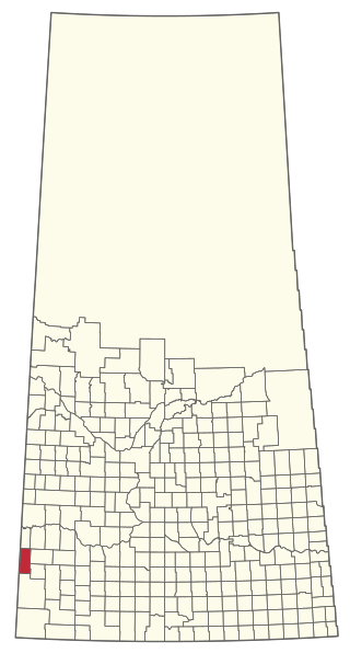
The Rural Municipality of Arlington No. 79 is a rural municipality (RM) in the Canadian province of Saskatchewan within Census Division No. 4 and SARM Division No. 3. It is located in the southwestern region of the province east of Shaunavon.

<span class="mw-page-title-main">Rural Municipality of Enterprise No. 142</span> Rural municipality in Saskatchewan, Canada

The Rural Municipality of Enterprise No. 142 is a rural municipality (RM) in the Canadian province of Saskatchewan within Census Division No. 8 and SARM Division No. 3. It is located in the southwest portion of the province.

<span class="mw-page-title-main">Rural Municipality of Lake Alma No. 8</span> Rural municipality in Saskatchewan, Canada

The Rural Municipality of Lake Alma No. 8 is a rural municipality (RM) in the Canadian province of Saskatchewan within Census Division No. 2 and SARM Division No. 2. Located in the southeast portion of the province, it is adjacent to the United States border, neighbouring Sheridan County in Montana and Divide County in North Dakota.

<span class="mw-page-title-main">Rural Municipality of Poplar Valley No. 12</span> Rural Municipality in Saskatchewan, Canada

The Rural Municipality of Poplar Valley No. 12 is a rural municipality (RM) in the Canadian province of Saskatchewan within Census Division No. 3 and SARM Division No. 2. It is located in the southern portion of the province. It is adjacent to the United States border, neighbouring Daniels County in Montana.

<span class="mw-page-title-main">Rural Municipality of Old Post No. 43</span> Rural Municipality in Saskatchewan, Canada

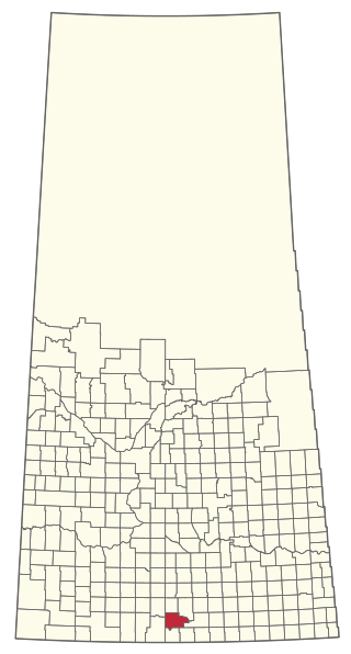
The Rural Municipality of Old Post No. 43 is a rural municipality (RM) in the Canadian province of Saskatchewan within Census Division No. 3 and SARM Division No. 2. It is located in the southern portion of the province adjacent to the United States border, neighbouring Valley County and Daniels County in Montana.

<span class="mw-page-title-main">Rural Municipality of Willow Bunch No. 42</span> Rural Municipality in Saskatchewan, Canada

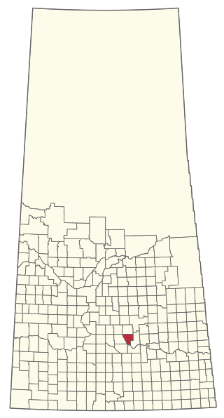
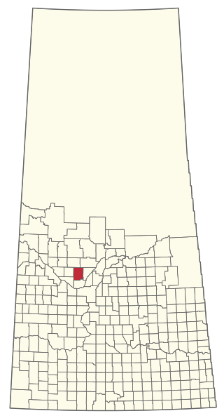
The Rural Municipality of Willow Bunch No. 42 is a rural municipality (RM) in the Canadian province of Saskatchewan within Census Division No. 3 and SARM Division No. 2. It is located in the south central portion of the province.

<span class="mw-page-title-main">Rural Municipality of Excel No. 71</span> Rural municipality in Saskatchewan, Canada

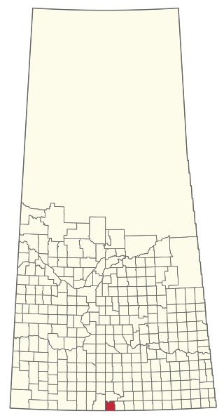
The Rural Municipality of Excel No. 71 is a rural municipality (RM) in the Canadian province of Saskatchewan within Census Division No. 3 and SARM Division No. 2. It is located in the south-central portion of the province.

<span class="mw-page-title-main">Rural Municipality of Wawken No. 93</span> Rural Municipality in Saskatchewan, Canada

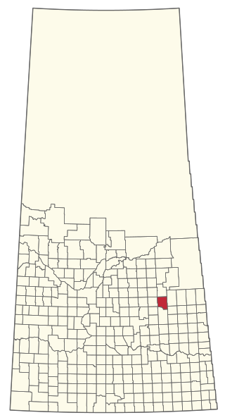
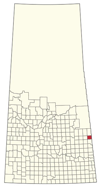
The Rural Municipality of Wawken No. 93 is a rural municipality (RM) in the Canadian province of Saskatchewan within Census Division No. 1 and SARM Division No. 1. It is located in the southeast portion of the province.

<span class="mw-page-title-main">Rural Municipality of Snipe Lake No. 259</span> Rural Municipality in Saskatchewan, Canada

The Rural Municipality of Snipe Lake No. 259 is a rural municipality (RM) in the Canadian province of Saskatchewan within Census Division No. 8 and SARM Division No. 3.

<span class="mw-page-title-main">Rural Municipality of Big River No. 555</span> Rural municipality in Saskatchewan, Canada

The Rural Municipality of Big River No. 555 is a rural municipality (RM) in the Canadian province of Saskatchewan within Census Division No. 16 and SARM Division No. 5.

<span class="mw-page-title-main">Rural Municipality of Cut Knife No. 439</span> Rural municipality in Saskatchewan, Canada

The Rural Municipality of Cut Knife No. 439 is a rural municipality (RM) in the Canadian province of Saskatchewan within Census Division No. 13 and SARM Division No. 6.

<span class="mw-page-title-main">Rural Municipality of Duck Lake No. 463</span> Rural municipality in Saskatchewan, Canada

The Rural Municipality of Duck Lake No. 463 is a rural municipality (RM) in the Canadian province of Saskatchewan within Census Division No. 15 and SARM Division No. 5.

<span class="mw-page-title-main">Rural Municipality of Three Lakes No. 400</span> Rural Municipality in Saskatchewan, Canada

The Rural Municipality of Three Lakes No. 400 is a rural municipality (RM) in the Canadian province of Saskatchewan within Census Division No. 15 and SARM Division No. 5.

<span class="mw-page-title-main">Rural Municipality of Mount Hope No. 279</span> Rural municipality in Saskatchewan, Canada

The Rural Municipality of Mount Hope No. 279 is a rural municipality (RM) in the Canadian province of Saskatchewan within Census Division No. 10 and SARM Division No. 5.

<span class="mw-page-title-main">Rural Municipality of Sasman No. 336</span> Rural municipality in Saskatchewan, Canada

The Rural Municipality of Sasman No. 336 is a rural municipality (RM) in the Canadian province of Saskatchewan within Census Division No. 10 and SARM Division No. 4.

<span class="mw-page-title-main">Rural Municipality of Pleasantdale No. 398</span> Rural Municipality in Saskatchewan, Canada

The Rural Municipality of Pleasantdale No. 398 is a rural municipality (RM) in the Canadian province of Saskatchewan within Census Division No. 14 and SARM Division No. 4.

<span class="mw-page-title-main">Rural Municipality of Redberry No. 435</span> Rural Municipality in Saskatchewan, Canada

The Rural Municipality of Redberry No. 435 is a rural municipality (RM) in the Canadian province of Saskatchewan within Census Division No. 16 and SARM Division No. 5.

<span class="mw-page-title-main">Rural Municipality of St. Philips No. 301</span> Rural Municipality in Saskatchewan, Canada

The Rural Municipality of St. Philips No. 301 is a rural municipality (RM) in the Canadian province of Saskatchewan within Census Division No. 9 and SARM Division No. 4.

References

  1. "Pre-packaged CSV files - CGN, Canada/Province/Territory (cgn_sk_csv_eng.zip)". Government of Canada. July 24, 2019. Retrieved May 23, 2020.
  2. 1 2 "Rural Municipality Incorporations (Alphabetical)". Saskatchewan Ministry of Municipal Affairs. Archived from the original on April 21, 2011. Retrieved May 9, 2020.
  3. 1 2 3 4 "Municipality Details: RM of Last Mountain Valley No. 250". Government of Saskatchewan. Retrieved May 21, 2020.
  4. 1 2 3 "Population and dwelling counts, for Canada, provinces and territories, and census subdivisions (municipalities), 2016 and 2011 censuses – 100% data (Saskatchewan)". Statistics Canada. February 8, 2017. Retrieved May 1, 2020.
  5. William Pearson Land Company
  6. "2019-2020 Rural Revenue Sharing Organized Hamlet Grant". Government of Saskatchewan. Retrieved May 4, 2020.
  7. "Last Mountain". Canadian Geographical Names Database. Government of Canada. Retrieved March 26, 2023.
  8. "History – Last Mountain Valley No. 250".
  9. "Last Mountain Regional Park". Canadian Geographical Names Database. Government of Canada. Retrieved March 29, 2023.
  10. "Last Mountain Regional Park | Tourism Saskatchewan".
  11. "Last Mountain Lake | Ramsar Sites Information Service". rsis.ramsar.org. Retrieved September 17, 2021.
  12. "Nature Saskatchewan".
  13. "Last Mountain".
  14. "Saskatchewan Census Population" (PDF). Saskatchewan Bureau of Statistics. Archived from the original (PDF) on September 24, 2015. Retrieved May 9, 2020.
  15. "Saskatchewan Census Population". Saskatchewan Bureau of Statistics. Retrieved May 9, 2020.
  16. "Population and dwelling counts: Canada, provinces and territories, census divisions and census subdivisions (municipalities), Saskatchewan". Statistics Canada. February 9, 2022. Retrieved April 13, 2022.