
The Rural Municipality of Corman Park No. 344 is a rural municipality (RM) that surrounds the City of Saskatoon in central Saskatchewan, Canada. It was formed in 1970 through the amalgamation of three smaller RMs – the RM of Cory No. 344, the RM of Warman No. 374, and the RM of Park No. 375. The RM is bisected by the South Saskatchewan River while the North Saskatchewan River forms part of its northwest boundary. The RM works closely with the Meewasin Valley Authority to protect the South Saskatchewan River valley.

Pike Lake Provincial Park is a primarily recreational park located approximately 32 km southwest of Saskatoon, Saskatchewan. It is operated under the Government of Saskatchewan's Ministry of Parks, Culture and Sport. It is located at the southern terminus of Highway 60 on the shore of Pike Lake, an oxbow created by the South Saskatchewan River. The Pike Lake area is part of the aspen parkland biome.
Furdale, Saskatchewan is an unincorporated community adjacent to the southern city limits of Saskatoon, west of Highway 219 and on the east bank of the South Saskatchewan River.
Floral, Saskatchewan is an unincorporated community in the province of Saskatchewan, Canada.
Eye Hill No. 382, Saskatchewan was established on December 12, 1910. It is a rural municipality in west-central Saskatchewan, Canada near the Alberta - Saskatchewan border. Eye Hill No. 382, Saskatchewan operates from Box 69, Macklin, SK S0L 2C0

Highway 316 is a highway in the Canadian province of Saskatchewan. It runs from Highway 16 near Clavet to Highway 5. Highway 316 is about 17 km (11 mi.) long. This area is an industrial commercial area along Highway #316 which extends from Clavet north to the PCS Patience Lake Mine which is just 10 miles from the city of Saskatoon. Highway 316 is a primary weight highway, and also runs near the Canadian National Railway line which goes from Saskatoon through Clavet. In 1941, the Canadian Pacific Railway ran from Saskatoon through Cheviot and on south eastward.

Rosedale No. 283, Saskatchewan is a rural municipality in central Saskatchewan, Canada along Highway 11 between Saskatoon and Regina. The two Local Improvement Districts of LID 15 B 3 and LID 15 C 3 combined together to form Rural Municipality of Rosedale No. 283, Saskatchewan. The formation of Rosedale originated on December 13, 1909
Leroy No. 339, Saskatchewan is a rural municipality in central Saskatchewan, east of Saskatoon. Leroy No. 339 started out with the name Roach from January 1, 1913 until March 14, 1914 when the name changed to Ayr. Ayr remained the name after 1914 through until February 27, 1931 when it became Leroy No. 339.

Eastview is a mostly residential neighbourhood located in south-central Saskatoon, Saskatchewan, Canada. It is a suburban subdivision, consisting of low-density, single detached dwellings, low-rise apartment buildings and semi-detached houses. As of 2007, the area is home to 3,566 residents. The neighbourhood is considered a middle-income area, with an average family income of $58,703, an average dwelling value of $260,050 and a home ownership rate of 51.6%. According to MLS data, the average sale price of a home as of 2013 was $318,449.
Haultain is a mostly residential neighbourhood located in south-central Saskatoon, Saskatchewan, Canada. It is a suburban subdivision, consisting mostly of low-density, single detached dwellings. As of 2007, the area is home to 2,742 residents. The neighbourhood is considered a middle-income area, with an average family income of $47,890, an average dwelling value of $201,503 and a home ownership rate of 59.3%. According to MLS data, the average sale price of a home as of 2013 was $316,411.

Queen Elizabeth is a mostly residential neighbourhood located in south-central Saskatoon, Saskatchewan, Canada. It is a suburban subdivision, consisting mostly of low-density, single detached dwellings. As of 2007, the area is home to 2,491 residents. The neighbourhood is considered a middle-income area, with an average family income of $61,904, an average dwelling value of $280,970 and a home ownership rate of 66.9%. According to MLS data, the average sale price of a home as of 2013 was $343,459.
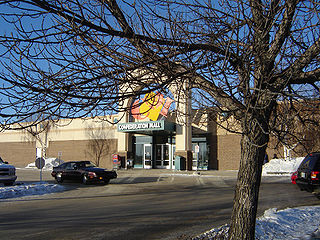
Confederation Mall is a 329,128 sq. ft. shopping mall located at 22nd Street and Circle Drive in Saskatoon, Saskatchewan, Canada. The mall was originally named Confederation Park Plaza when it opened in mid-1973, at which time its anchor tenants were Canada Safeway and Woolco.

The Exhibition subdivision of Saskatoon, Saskatchewan, Canada, is located on the banks of the South Saskatchewan River and was developed between the two major World Wars. To the west is the Diefenbaker Management Area which boasts the Diefenbaker park and Pioneer Cemetery. The park includes a medium-sized hill which is used for tobogganing and snowboarding, and the park itself is a frequently-used venue for picnics and public events and performances. The Exhibition community is also known as Thornton, after a (now-decommissioned) elementary school that formerly served the area and early in its history also went by the name Bellevue.
8th Street East is a road serving the city of Saskatoon, Saskatchewan. It begins as a continuation of a minor residential street at Highway 219 in Saskatoon, and runs through the city, eventually exiting the city limits, going through the eastern part of Corman Park Rural Municipality and continuing to Range Road 3033 in the Blucher Rural Municipality near Patience Lake.

Adelaide/Churchill is a mostly residential neighbourhood located in south-central Saskatoon, Saskatchewan, Canada. It is a suburban subdivision, consisting mostly of low-density, single detached dwellings. As of 2009, the area is home to 3,445 residents. The neighbourhood is considered a middle-income area, with an average family income of $78,438, an average dwelling value of $287,976 and a home ownership rate of 90.3%. According to MLS data, the average sale price of a home as of 2013 was $350,096.

Avalon is a mostly residential neighbourhood located in south-central Saskatoon, Saskatchewan, Canada. It is a suburban subdivision, consisting mostly of low-density, single detached dwellings. As of 2007, the area is home to 3,214 residents. The neighbourhood is considered a middle-income area, with an average family income of $65,000, an average dwelling value of $168,444 and a home ownership rate of 77.3%. According to MLS data, the average sale price of a home as of 2013 was $352,359.

Stonebridge is a mostly residential neighbourhood located in south-central Saskatoon, Saskatchewan, Canada. It is a suburban subdivision, consisting of low-density, single detached dwellings and a mix of medium-density apartment and semi-detached dwellings. As of 2009, the area is home to 994 residents. The neighbourhood is considered a middle-income area, with an average family income of $67,642, an average dwelling value of $321,004 and a home ownership rate of 72.4%. According to MLS data, the average sale price of a home as of 2013 was $380,777.

The Willows Residential Community and Golf Club, is a residential community in the Nutana Suburban Development Area in the city of Saskatoon, Saskatchewan. The Willows is south of Circle Drive which is concurrent with Saskatchewan Highway 16. Its northern boundary is the CN Rail line and the former Cartwright Street right-of-way ; to the east is Clarence Avenue and to the west is Lorne Avenue. The 36-hole Willows Golf & Country Club winds its way around the subdivision which when construction of homes began in 2004 became the city's first golf course community. Home construction began almost immediately after the land for the subdivision and the golf course was annexed from the rural municipality of Corman Park No. 344, Saskatchewan. The golf course, however, had been in operation for more than a decade before residential development began. According to MLS data, the average sale price of a home as of 2013 was $824,493.

The CN Industrial Area is the industrial subdivision located in southern Saskatoon. It is also known as South Saskatoon, after the CN rail siding located in the area. It is a part of the Nutana Suburban Development Area. This industrial park was established with the Grand Trunk Pacific Railway crossing the South Saskatchewan River.


