
The Rural Municipality of Storthoaks No. 31 is a rural municipality (RM) in the Canadian province of Saskatchewan within Census Division No. 1 and SARM Division No. 1.

The Rural Municipality of Porcupine No. 395 is a rural municipality (RM) in the Canadian province of Saskatchewan within Census Division No. 14 and SARM Division No. 4. It is located in the northeast-central portion of the province.
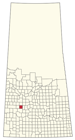
Drake is a village in the Canadian province of Saskatchewan within the Rural Municipality of Usborne No. 310 and Census Division No. 11. The village lies west of Highway 20, approximately 11 kilometres (6.8 mi) south of its intersection with the Yellowhead Highway.

The Rural Municipality of Bone Creek No. 108 is a rural municipality (RM) in the Canadian province of Saskatchewan within Census Division No. 4 and SARM Division No. 3. It is located in the southwest portion of the province.

The Rural Municipality of South Qu'Appelle No. 157 is a rural municipality (RM) in the Canadian province of Saskatchewan within Census Division No. 6 and SARM Division No. 1. It is located in the southeast portion of the province.
Kincaid is a village in the Canadian province of Saskatchewan within the Rural Municipality of Pinto Creek No. 75 and Census Division No. 3.
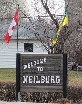
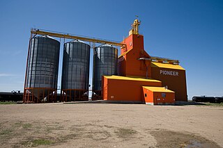
Neilburg is a village in the Canadian province of Saskatchewan within the Rural Municipality of Hillsdale No. 440 and Census Division No. 13. A grade K–12 school is located in the village that services the Neilburg area as well as grade 7–12 students from Marsden.

The Rural Municipality of Usborne No. 310 is a rural municipality (RM) in the Canadian province of Saskatchewan within Census Division No. 11 and SARM Division No. 5. It is located in the central portion of the province.

The Rural Municipality of Foam Lake No. 276 is a rural municipality (RM) in the Canadian province of Saskatchewan within Census Division No. 10 and SARM Division No. 4. It is located in the east-central portion of the province.
Weekes is a village in the Canadian province of Saskatchewan within the Rural Municipality of Porcupine No. 395 and Census Division No. 14. The village is located 29 km east of the town of Porcupine Plain on Highway 23.

Sunset View Beach is an organized hamlet in the Canadian province of Saskatchewan within the RM of Mervin No. 499 and Census Division No. 17. Part of the RM of Parkdale No. 498 prior to September 1992, it subsequently held resort village status until it dissolved to become part of the RM of Mervin No. 499 in January 2015. Sunset View Beach is on the southeast shore of Turtle Lake, approximately 43 kilometres (27 mi) northeast of the town of Turtleford and 102 kilometres (63 mi) north of the city of North Battleford.
The Rural Municipality of Excel No. 71 is a rural municipality (RM) in the Canadian province of Saskatchewan within Census Division No. 3 and SARM Division No. 2. It is located in the south-central portion of the province.
The Rural Municipality of Elmsthorpe No. 100 is a rural municipality (RM) in the Canadian province of Saskatchewan within Census Division No. 2 and SARM Division No. 2. It is located in the southeast portion of the province.

The Rural Municipality of Emerald No. 277 is a rural municipality (RM) in the Canadian province of Saskatchewan within Census Division No. 10 and SARM Division No. 4.

The Rural Municipality of Parkdale No. 498 is a rural municipality (RM) in the Canadian province of Saskatchewan within Census Division No. 17 and SARM Division No. 6.

The Rural Municipality of Pleasant Valley No. 288 is a rural municipality (RM) in the Canadian province of Saskatchewan within Census Division No. 12 and SARM Division No. 6.
The Rural Municipality of St. Andrews No. 287 is a rural municipality (RM) in the Canadian province of Saskatchewan within Census Division No. 12 and SARM Division No. 6.
Lockwood is a former village in the Canadian province of Saskatchewan. It was dissolved in 2002; its population is now counted as part of the Rural Municipality of Usborne No. 310. Lockwood is located on Highway 20 15 kilometres (9.3 mi) north of the town of Nokomis.

