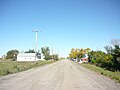
Coleville is a village in the Canadian province of Saskatchewan within the Rural Municipality of Oakdale No. 320 and Census Division No. 13. The village's main economic factors are oil and farming, namesake of the Coleville oilfields. The village is named for Malcolm Cole who became the community's first postmaster in 1908.
Aylesbury is a village in the Canadian province of Saskatchewan within the Rural Municipality of Craik No. 222 and Census Division No. 7. The village is approximately 60 km north of the City of Moose Jaw.

Dawson Creek is a city in northeastern British Columbia, Canada. The municipality of 24.37 square kilometres (9.41 sq mi) had a population of 12,978 in 2016. Dawson Creek derives its name from the creek of the same name that runs through the community. The creek was named after George Mercer Dawson by a member of his land survey team when they passed through the area in August 1879. Once a small farming community, Dawson Creek became a regional centre after the western terminus of the Northern Alberta Railways was extended there in 1932. The community grew rapidly in 1942 as the US Army used the rail terminus as a transshipment point during construction of the Alaska Highway. In the 1950s, the city was connected to the interior of British Columbia via a highway and a railway through the Rocky Mountains. Since the 1960s, growth has slowed, but the area population has increased.

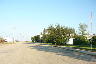
Sintaluta is a town in Saskatchewan, Canada. The population of Sintaluta is approximately 119 people according to the 2016 Canadian Census. The town is located about 85 km east of Regina. The town is on the north side of the Trans-Canada Highway.
Pilot Butte, meaning "lookout point", is a town in southeast Saskatchewan. Situated between Highway 46 and the Trans-Canada Highway, the town is part of the White Butte region and neighbours Balgonie, White City, and the province's capital city, Regina. As of the 2021 Canadian census, Pilot Butte had a population of 2,638, indicating 23% growth from 2016. The town is governed by the Pilot Butte Town Council and is surrounded by the Rural Municipality of Edenwold No. 158. Pilot Butte is located in Treaty 4 territory.

Stirling is a village in southern Alberta, Canada that is surrounded by the County of Warner No. 5. The village is located on Highway 4, approximately 31 km (19 mi) southeast of Lethbridge and 72 km (45 mi) northwest of the Canada–US border.

Goodwater is a village in the Canadian province of Saskatchewan within the Rural Municipality of Lomond No. 37 and Census Division No. 2. The village is located approximately 50 km (31 mi) south of the City of Weyburn. Goodwater is located on Treaty 4 land, negotiated between the Cree, Saulteaux, and Assiniboine first peoples, and Alexander Morris, second Lieutenant Governor of Manitoba (1872–1877). Goodwater is currently part of the Souris - Moose Mountain federal riding.
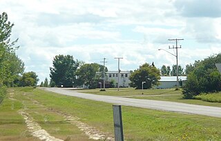
Love is a village in the Canadian province of Saskatchewan within the Rural Municipality of Torch River No. 488 and Census Division No. 14. The village is northeast of the City of Prince Albert and about 48 km (30 mi) south of Prince Albert National Park boundaries and 16 km (9.9 mi) south of Torch River Provincial Forest.
Bengough is a town surrounded by the rural municipality of Bengough No. 40, in the Canadian province of Saskatchewan. A southeastern Saskatchewan prairie town, Bengough is located east of Willow Bunch Lake on Highway 34 near Highway 705. The town is named Bengough after cartoonist John Wilson Bengough. Bengough also plays host to the Gateway Festival which showcases various musicians and several other events through the weekend, usually taking place in late July.

Carlyle is a town in the province of Saskatchewan, Canada. Carlyle is the largest town servicing the far south-eastern corner of Saskatchewan and as a result, has become the economic and services centre of the region. Estevan and Weyburn are the closest cities and both are a little over 100 kilometres away. Regina, the provincial capital, lies 200 km to the north-west.
Estuary is a hamlet in RM of Deer Forks No. 232 in the Canadian province of Saskatchewan. Very little remains of the former village of 800, other than a private residence and a pioneer cemetery on a small hill known as Cemetery Hill, overlooking the South Saskatchewan River.
Senate is an unincorporated community within the Rural Municipality of Reno No. 51, Saskatchewan, Canada. The village had a population of 63 around 1940 and has since declined to 0 residents. The townsite is located along Hwy 21 & the historic Red Coat Trail, about 20 km east of the Alberta-Saskatchewan border and is about 200 km southwest of the city of Swift Current.

Englefeld is a village in the Canadian province of Saskatchewan within the Rural Municipality of St. Peter No. 369 and Census Division No. 15. The village is located 32 kilometres east of the City of Humboldt on Highway 5.
Gladmar is a Dissolved village in the Canadian province of Saskatchewan located 2 kilometres (1.2 mi) north of Highway 18 as it runs east from Highway 6 towards Lake Alma. Gladmar is approximately 18.4 kilometres (11.4 mi) north of the Canada–United States border between Canada and the United States. It is part of the Rural Municipality of Surprise Valley No. 9 and Census Division No. 2.

Harris is a village in the Canadian province of Saskatchewan within the Rural Municipality of Harris No. 316 and Census Division No. 12. It was the site of the Great Ruby Hoax in 1914. Harris was named for Richard Elford Harris, an early settler to the area.
Hawarden is a village in the Canadian province of Saskatchewan within the Rural Municipality of Loreburn No. 254 and Census Division No. 11. The village is located on Highway 19 north of Strongfield, Loreburn, and Elbow.
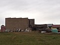
Herschel is a special service area in the Canadian province of Saskatchewan. It is the seat of the Rural Municipality of Mountain View No. 318 and held village status prior to December 31, 2006. The population was 30 people in 2016. The community is located 37 km northwest of the town of Rosetown at the intersection of Highway 31 and Highway 656, along a now abandoned section of the Kerrobert-Rosetown Canadian Pacific Railway line. Herschel is the home of the Ancient Echoes Interpretive Centre. The Vancouver-based backpack manufacturer Herschel Supply Co., founded by Lyndon and Jamie Cormack in 2009, adopted the name of Herschel, the town where three generations of their family grew up.
Ruthilda is a former village in the Rural Municipality of Grandview No. 349, Saskatchewan, Canada. It dissolved from village status to become part of the Rural Municipality of Grandview No. 349 on December 31, 2013. Ruthilda is located about 5 km south of Highway 51 approximately 30 km southwest of the Town of Biggar.

Bromhead is an unincorporated community and ghost town in Souris Valley Rural Municipality No. 7, Saskatchewan, Canada. The community is approximately 5 km (3.1 mi) north of Highway 18 and 45 km (28 mi) west of the City of Estevan.

Horizon, located on the south side of Channel Lake, is a hamlet in Bengough Rural Municipality No. 40, Saskatchewan, Canada. It previously held the status of village until December 31, 1973. The hamlet is located 60 km (37 mi) east of the Town of Assiniboia on highway 13.