Rural Municipality of Arlington No. 79

Last updated

Arlington No. 79
Rural Municipality of Arlington No. 79
RM of Arlington office, Shaunavon.jpg
Administrative office in Shaunavon
SK RM 79 Arlington.svg
Location of the RM of Arlington No. 79 in Saskatchewan
Coordinates: 49°37′26″N108°39′32″W / 49.624°N 108.659°W / 49.624; -108.659 [1]
Country Canada
Province Saskatchewan
Census division 4
SARM division 3
Federal riding Cypress Hills—Grasslands
Provincial riding Cypress Hills
Formed [2] January 1, 1913
Government
[3]
   Reeve Donald Lundberg
  Governing bodyRM of Arlington No. 79 Council
  AdministratorRichard Goulet
  Office location Shaunavon
Area
 (2016) [4]
  Land846.79 km2 (326.95 sq mi)
Population
 (2016) [4]
  Total366
  Density0.4/km2 (1/sq mi)
Time zone CST
  Summer (DST) CST
Postal code
S0N 2M0
Area code(s) 306 and 639
Highway(s) Highway 13
Highway 613
Highway 633
Highway 724
Waterway(s) Lawrence Lake
Jones Creek
Swift Current Creek
Eastend Coulee
Rock Creek

The Rural Municipality of Arlington No. 79 (2016 population: 366) is a rural municipality (RM) in the Canadian province of Saskatchewan within Census Division No. 4 and SARM Division No. 3. It is located in the southwestern region of the province east of Shaunavon.

Contents

History

The RM of Arlington No. 79 incorporated as a rural municipality on January 1, 1913. [2]

Geography

Communities and localities

The following unincorporated communities are within the RM.

Localities

Pine Cree Regional Park

Pine Cree Regional Park ( 49°36′44″N108°45′17″W / 49.6122°N 108.7546°W / 49.6122; -108.7546 ) [5] is a park in the RM, just north of the Highway 13 and 633 junction between Shaunavon and Eastend.

The park was officially founded as a regional park in 1970 as a small natural environment park. Prior to being a regional park, Everett Baker began developing the area in the 1950s as a place for people to go to appreciate nature. The formation of the park was to commemorate Everett Baker and Irish-Canadian naturalist John Macoun, with the Geological Survey of Canada. John Macoun had camped extensively in the area in the 1880s.

The park is situated alongside Swift Current Creek and features 27 campsites, a picnic area, hiking, a camp kitchen, and wildlife viewing. [6] [7]

Demographics

Population history
(1981–2016)
YearPop.±%
1981432    
1986428−0.9%
1991351−18.0%
1996 335−4.6%
2001 336+0.3%
2006 413+22.9%
2011 345−16.5%
2016 366+6.1%
Source: Statistics Canada via Saskatchewan Bureau of Statistics [8] [9]

In the 2021 Census of Population conducted by Statistics Canada, the RM of Arlington No. 79 had a population of 359 living in 87 of its 99 total private dwellings, a change of

In the 2016 Census of Population, the RM of Arlington No. 79 recorded a population of 366 living in 84 of its 97 total private dwellings, a

Government

The RM of Arlington No. 79 is governed by an elected municipal council and an appointed administrator that meets on the second Wednesday of every month. [3] The reeve of the RM is Donald Lundberg while its administrator is Richard Goulet. [3] The RM's office is located in Shaunavon. [3]

Transportation

HighwayStarting pointCommunitiesEnding point
Highway 13 Alberta Highway 501 Dollard Manitoba Highway 3
Highway 613 Highway 724 Dollard Highway 18
Highway 633 Tompkins South Fork Saskatchewan Highway 13
Highway 724 Highway 614 Highway 37

See also

Related Research Articles

<span class="mw-page-title-main">Rural Municipality of Craik No. 222</span> Rural Municipality in Saskatchewan, Canada

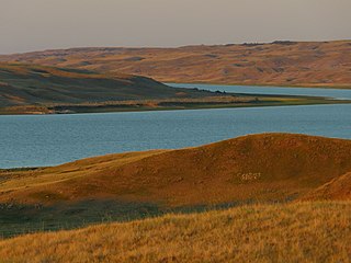
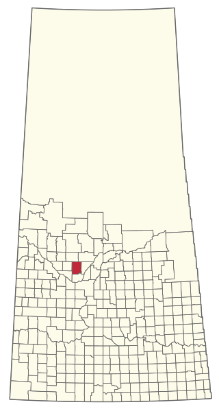
The Rural Municipality of Craik No. 222 is a rural municipality (RM) in the Canadian province of Saskatchewan within Census Division No. 7 and SARM Division No. 2. The RM is centrally located between the cities of Regina and Saskatoon.

<span class="mw-page-title-main">Rural Municipality of Leask No. 464</span> Rural municipality in Saskatchewan, Canada

The Rural Municipality of Leask No. 464 is a rural municipality (RM) in the Canadian province of Saskatchewan within Census Division No. 16 and SARM Division No. 5. It is located west of the city of Prince Albert.

<span class="mw-page-title-main">Rural Municipality of Canwood No. 494</span> Rural municipality in Saskatchewan, Canada

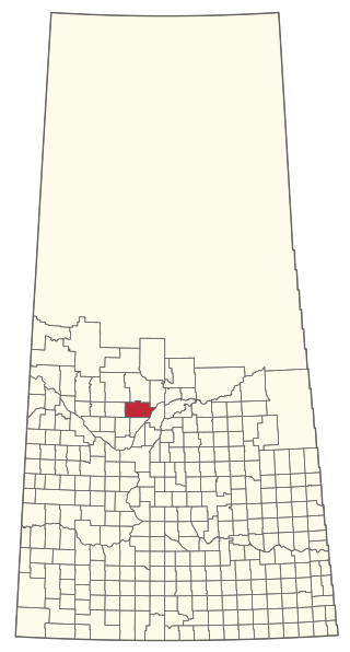
The Rural Municipality of Canwood No. 494 is a rural municipality (RM) in the Canadian province of Saskatchewan within Census Division No. 16 and SARM Division No. 5. The RM is located in the north-central portion of the province, west of the city of Prince Albert.

<span class="mw-page-title-main">Rural Municipality of Kelvington No. 366</span> Rural Municipality in Saskatchewan, Canada

The Rural Municipality of Kelvington No. 366 is a rural municipality (RM) in the Canadian province of Saskatchewan within Census Division No. 14 and SARM Division No. 4. It is located in the southeast portion of the province.

<span class="mw-page-title-main">Rural Municipality of Key West No. 70</span> Rural Municipality in Saskatchewan, Canada

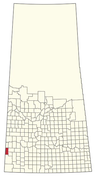
The Rural Municipality of Key West No. 70 is a rural municipality (RM) in the Canadian province of Saskatchewan within Census Division No. 2 and SARM Division No. 2. It is located in the southwest portion of the province.

<span class="mw-page-title-main">Rural Municipality of Bone Creek No. 108</span> Rural Municipality in Saskatchewan, Canada

The Rural Municipality of Bone Creek No. 108 is a rural municipality (RM) in the Canadian province of Saskatchewan within Census Division No. 4 and SARM Division No. 3. It is located in the southwest portion of the province.

<span class="mw-page-title-main">Rural Municipality of Enterprise No. 142</span> Rural municipality in Saskatchewan, Canada

The Rural Municipality of Enterprise No. 142 is a rural municipality (RM) in the Canadian province of Saskatchewan within Census Division No. 8 and SARM Division No. 3. It is located in the southwest portion of the province.

<span class="mw-page-title-main">Rural Municipality of Wise Creek No. 77</span> Rural Municipality in Saskatchewan, Canada

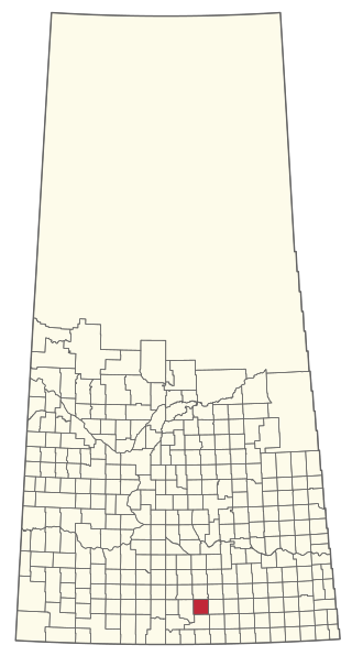
The Rural Municipality of Wise Creek No. 77 is a rural municipality (RM) in the Canadian province of Saskatchewan within Census Division No. 4 and SARM Division No. 3. It is located in the southwest portion of the province near Admiral.

<span class="mw-page-title-main">Rural Municipality of Grassy Creek No. 78</span> Rural Municipality in Saskatchewan, Canada

The Rural Municipality of Grassy Creek No. 78 is a rural municipality (RM) in the Canadian province of Saskatchewan within SARM Division No. 3.

<span class="mw-page-title-main">Rural Municipality of Britannia No. 502</span> Rural municipality in Saskatchewan, Canada

The Rural Municipality of Britannia No. 502 is a rural municipality (RM) in the Canadian province of Saskatchewan within Census Division No. 17 and SARM Division No. 6. It is located in the west-central portion of the province.

<span class="mw-page-title-main">Rural Municipality of Pittville No. 169</span> Rural Municipality in Saskatchewan, Canada

The Rural Municipality of Pittville No. 169 is a rural municipality (RM) in the Canadian province of Saskatchewan within Census Division No. 8 and SARM Division No. 3. Located in the southwest portion of the province, it is northwest of the town of Gull Lake.

<span class="mw-page-title-main">Rural Municipality of Marriott No. 317</span> Rural Municipality in Saskatchewan, Canada

The Rural Municipality of Marriott No. 317 is a rural municipality (RM) in the Canadian province of Saskatchewan within Census Division No. 12 and SARM Division No. 6.

<span class="mw-page-title-main">Rural Municipality of Spy Hill No. 152</span> Rural Municipality in Saskatchewan, Canada

The Rural Municipality of Spy Hill No. 152 is a rural municipality (RM) in the Canadian province of Saskatchewan within Census Division No. 5 and SARM Division No. 1. It is located in the east-central portion of the province.

<span class="mw-page-title-main">Rural Municipality of Cymri No. 36</span> Rural Municipality in Saskatchewan, Canada

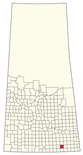
The Rural Municipality of Cymri No. 36 is a rural municipality (RM) in the Canadian province of Saskatchewan within Census Division No. 2 and SARM Division No. 1. It is located in the southeast portion of the province.

<span class="mw-page-title-main">Rural Municipality of Snipe Lake No. 259</span> Rural Municipality in Saskatchewan, Canada

The Rural Municipality of Snipe Lake No. 259 is a rural municipality (RM) in the Canadian province of Saskatchewan within Census Division No. 8 and SARM Division No. 3.

<span class="mw-page-title-main">Rural Municipality of Riverside No. 168</span> Rural Municipality in Saskatchewan, Canada

The Rural Municipality of Riverside No. 168 is a rural municipality (RM) in the Canadian province of Saskatchewan within Census Division No. 8 and SARM Division No. 3.

<span class="mw-page-title-main">Rural Municipality of Kinistino No. 459</span> Rural Municipality in Saskatchewan, Canada

The Rural Municipality of Kinistino No. 459 is a rural municipality (RM) in the Canadian province of Saskatchewan within Census Division No. 15 and SARM Division No. 5.

<span class="mw-page-title-main">Rural Municipality of Last Mountain Valley No. 250</span> Rural Municipality in Saskatchewan, Canada

The Rural Municipality of Last Mountain Valley No. 250 is a rural municipality (RM) in the Canadian province of Saskatchewan within Census Division No. 11 and SARM Division No. 5.

<span class="mw-page-title-main">Rural Municipality of Pleasantdale No. 398</span> Rural Municipality in Saskatchewan, Canada

The Rural Municipality of Pleasantdale No. 398 is a rural municipality (RM) in the Canadian province of Saskatchewan within Census Division No. 14 and SARM Division No. 4.

<span class="mw-page-title-main">Rural Municipality of Redberry No. 435</span> Rural Municipality in Saskatchewan, Canada

The Rural Municipality of Redberry No. 435 is a rural municipality (RM) in the Canadian province of Saskatchewan within Census Division No. 16 and SARM Division No. 5.

References

  1. "Pre-packaged CSV files - CGN, Canada/Province/Territory (cgn_sk_csv_eng.zip)". Government of Canada. July 24, 2019. Retrieved May 23, 2020.
  2. 1 2 "Rural Municipality Incorporations (Alphabetical)". Saskatchewan Ministry of Municipal Affairs. Archived from the original on April 21, 2011. Retrieved May 9, 2020.
  3. 1 2 3 4 "Municipality Details: RM of Arlington No. 79". Government of Saskatchewan. Retrieved May 21, 2020.
  4. 1 2 3 "Population and dwelling counts, for Canada, provinces and territories, and census subdivisions (municipalities), 2016 and 2011 censuses – 100% data (Saskatchewan)". Statistics Canada. February 8, 2017. Retrieved May 1, 2020.
  5. Government of Canada, Natural Resources Canada. "Place names - Pine Cree Regional Park (Pine Cree Section)". www4.rncan.gc.ca.
  6. "Pine Cree".
  7. "Pine Cree Regional Park | Tourism Saskatchewan".
  8. "Saskatchewan Census Population" (PDF). Saskatchewan Bureau of Statistics. Archived from the original (PDF) on September 24, 2015. Retrieved May 9, 2020.
  9. "Saskatchewan Census Population". Saskatchewan Bureau of Statistics. Retrieved May 9, 2020.
  10. "Population and dwelling counts: Canada, provinces and territories, census divisions and census subdivisions (municipalities), Saskatchewan". Statistics Canada. February 9, 2022. Retrieved April 13, 2022.