Rosthern is a town at the juncture of Highway 11 and Highway 312 in central Saskatchewan, Canada. It is roughly halfway between the cities of Prince Albert and Saskatoon.

Chamberlain is a village in the Canadian province of Saskatchewan within the Rural Municipality of Sarnia No. 221 and Census Division No. 6.

Annaheim is a village in the Canadian province of Saskatchewan within the Rural Municipality of St. Peter No. 369 and Census Division No. 15. The village is located about 125 km east of the City of Saskatoon, at the junction of provincial Highway 756 and Highway 779. Annaheim hosts the offices of the Rural Municipality of St. Peter No. 369.

Hepburn is a town in Saskatchewan, Canada, approximately 45 kilometres north of Saskatoon.

Langham is a town in Saskatchewan, Canada. It is on Highway 16, surrounded by the Rural Municipality of Corman Park No. 344, and about 35 kilometres (22 mi) northwest of the city of Saskatoon. The 2011 census reported a population of 1,290, with 489 homes in the community.

The Rural Municipality of Corman Park No. 344 is a rural municipality (RM) in the Canadian province of Saskatchewan within Census Division No. 11 and SARM Division No. 5. Located in the central portion of the province, the RM surrounds the City of Saskatoon.

Hague is a small rural town in Saskatchewan, Canada, located approximately 47 kilometres north of Saskatoon. Hague was established in the late nineteenth century as a Mennonite community farming the fertile land in the area.
Highway 219 is a provincial highway in the Canadian province of Saskatchewan. Saskatchewan's 200-series highways primarily service its recreational areas. The highway runs from Gardiner Dam at the north end of Lake Diefenbaker north to the city Saskatoon. It is about 96 kilometres (60 mi) long.

Strongfield is a village in the Canadian province of Saskatchewan within the Rural Municipality of Loreburn No. 254 and Census Division No. 11. It lies approximately 100 km south of the city of Saskatoon on Highway 19 between its sister communities of Hawarden and Loreburn.
Wilkie is a town in the Canadian province of Saskatchewan, located at Section 5, Township 40, Range 19, west of the 3rd Meridian. The town is at the junctions of Highways 14, 29, and 784.

The Rural Municipality of Rosedale No. 283 is a rural municipality (RM) in the Canadian province of Saskatchewan within Census Division No. 11 and SARM Division No. 5. It is located in the central portion of the province along Highway 11 between Saskatoon and Regina.

The Exhibition subdivision of Saskatoon, Saskatchewan, Canada, is located on the banks of the South Saskatchewan River and was developed between the two major World Wars. To the west is the Diefenbaker Management Area which boasts the Diefenbaker park and Pioneer Cemetery. The park includes a medium-sized hill which is used for tobogganing and snowboarding, and the park itself is a frequently-used venue for picnics and public events and performances. The Exhibition community is also known as Thornton, after a (now-demolished) public elementary school that formerly served the area and early in its history also went by the name Bellevue.

Waldheim is a town of 1,035 residents in the Rural Municipality of Laird No. 404, in the Canadian province of Saskatchewan, 57 kilometres (35 mi) north of Saskatoon. Waldheim is located on Highway 312 in central Saskatchewan, the "Heart of the Old North-Wes". Fort Carlton, Batoche, Battle of Fish Creek, and Seager Wheeler's Maple Grove Farm are all near Waldheim.

The Willows Residential Community and Golf Club, is a residential community in the Nutana Suburban Development Area in the city of Saskatoon, Saskatchewan. The Willows is south of Circle Drive which is concurrent with Saskatchewan Highway 16. Its northern boundary is the CN Rail line and the former Cartwright Street right-of-way ; to the east is Clarence Avenue and to the west is Lorne Avenue. The 36-hole Willows Golf & Country Club winds its way around the subdivision which when construction of homes began in 2004 became the city's first golf course community. Home construction began almost immediately after the land for the subdivision and the golf course was annexed from the rural municipality of Corman Park No. 344, Saskatchewan. The golf course, however, had been in operation for more than a decade before residential development began.
Central Butte is a town in Saskatchewan, Canada, approximately 200 kilometres (120 mi) from Saskatoon, Regina and Swift Current and 100 kilometres (62 mi) from Moose Jaw. Thunder Creek, a major tributary of the Moose Jaw River, begins west of the community. The town is served by the Central Butte Airport.

Vonda is located on Highway 27, a half-hour drive north east of Saskatoon, Saskatchewan. The town was named after the daughter of American journalist Cy Warman.

Eyebrow is a village in the Canadian province of Saskatchewan within the Rural Municipality of Eyebrow No. 193 and Census Division No. 7. The community originated at the location that is now the abandoned community of Eskbank several kilometres to the south. Eyebrow is located at the intersection of Highway 367 and Highway 42; 84 km northwest of Moose Jaw, 154 km northwest of Regina and 196 km south of Saskatoon.

Meacham is a village in the Canadian province of Saskatchewan within the Rural Municipality of Colonsay No. 342 and Census Division No. 11. It is located 69 kilometres east of the City of Saskatoon on Highway 2.

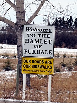
Grasswood, also known as Grasswood Park, is an unincorporated hamlet in Saskatchewan. It is part of the Corman Park rural municipality and is located just south of the city limits of Saskatoon. A second unincorporated hamlet, Furdale, is directly to the west.
The Rural Municipality of Mountain View No. 318 is a rural municipality (RM) in the Canadian province of Saskatchewan within Census Division No. 12 and SARM Division No. 6.