Pipestone Creek (Saskatchewan)

Last updated

Pipestone Creek
Pipestone Creek Mb.jpg
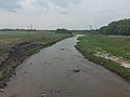
Pipestone Creek near Cromer, Manitoba
Sourisrivermap.png
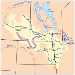
The Red River drainage basin, with the Souris River highlighted
Location
Countries
  • Canada
Provinces
Communities
Physical characteristics
SourceSouth of Grenfell
  location Saskatchewan
Mouth Oak Lake
  location
Manitoba, Canada
  elevation
426 m (1,398 ft)
Basin size2,242 km2 (866 sq mi)
Basin features
River system Red River drainage basin
Tributaries 
  leftLittle Pipestone Creek
  rightMontgomery Creek
[1] [2]

Pipestone Creek [3] is a river [4] in the Souris River watershed. [5] Its flow begins in southeastern Saskatchewan, just south of the town of Grenfell and travels in a southeastern direction into Manitoba in the Westman Region where it empties into Oak Lake through the Oak Lake Marsh.

Contents

The Pipestone Creek is in a region called the Prairie Pothole Region of North America, which extends throughout three Canadian provinces and five U.S. states. It is also within Palliser's Triangle. [6] The topographical basin of Pipestone Creek's watershed ranges from 804 to 426 metres above sea level (asl), with a mean elevation of 650 asl.

"The Pothole Region is the result of the last Pleistocene glaciation and it is estimated that there are between 5 and 8 million wetlands or small depressions, which have an important biological role and impact on the ecosystem. It is estimated that the Pipestone Creek has a GDA (Gross Drainage Area) and EDA (Effective Drainage Area) of 2,242 km2 (866 sq mi) and 559 km2 (216 sq mi), respectively, and that near 11% of the watershed is covered by wetlands." [7]

Most of the waters that flow into the Pipestone Creek depend upon rains and melting snow. There are no large natural lakes in its watershed. Saskatchewan and Manitoba have waterflow agreements regulating how much water Saskatchewan must allow to flow down Pipestone Creek into Manitoba. Saskatchewan has always met its requirements. [8] Pipestone Creek and nearby Stony Creek [9] are the two main tributaries to Oak Lake Aquifer, which is an important source of water in south-west Manitoba.

Course

The Pipestone Creek follows the path of the Pipestone Spillway, which is a valley that was created during the melting of the last glaciation about 15,000 years ago. The headwater for the spillway was glacial Lake Indian Head. [10] [11] From its headwaters, the creek travels in a south-easterly direction and flows through Ochapowace Nation then into Pipestone Lake, [12] a man-made lake with an earthen dam. From there it winds its way past Saint Hubert Mission, an early French colony. South of the town of Moosomin, Saskatchewan, the creek flows into another man-made lake, Moosomin Lake. Moosomin Dam, owned and operated by the Saskatchewan Water Security Agency, is also an earthen dam that was completed in 1955. From Moosomin Lake, the creek continues south-east where is crosses the border into Manitoba. Just across the border, the creek winds past Kola and Butler on its way to Cromer. From Cromer, it continues in a more southerly direction until it nears Reston where it heads east towards the communities of Pipestone and Oak Lake Indian Reserve. From there it heads north-east through Oak Lake Marsh and into Oak Lake through the Pipestone Creek Diversion. [13] Oak Lake flows into the Plum Lakes which flow into the Souris River via the Plum Creek.

Tributaries

See also

Related Research Articles

<span class="mw-page-title-main">Souris River</span> River in Canada and the United States

The Souris River or Mouse River is a river in central North America. Approximately 435 miles (700 km) in length, it drains about 23,600 square miles (61,100 km2) in Canada and the United States.

<span class="mw-page-title-main">Fishing Lakes</span> Chain of lakes in Saskatchewan, Canada

The Fishing Lakes, also called the Calling Lakes or the Qu'Appelle Lakes, are a chain of four lakes in the Qu'Appelle Valley cottage country about 40 miles (64 km) to the north-east of Regina in the Canadian province of Saskatchewan. The lakes are in a region called the Prairie Pothole Region of North America, which extends throughout three Canadian provinces and five U.S. states. It is also within Palliser's Triangle and the Great Plains ecoregion. The Fishing Lakes all follow the course of the Qu'Appelle River, which flows from the west to the east and is part of the Hudson Bay drainage basin. The lakes sit in the deep-cut Qu'Appelle Valley that was formed about 14,000 years ago during the last ice age. Meltwater from the glaciers carved out the valley and as water levels rose and fell, alluvium was left in the wake. These piles of alluvium are what created the separations between the lakes.

<span class="mw-page-title-main">Antler River</span> River in central North America

The Antler River is located in the Prairie Pothole Region of North America's Great Plains in south-eastern Saskatchewan and south-western Manitoba in Canada in an area known as Palliser's Triangle. Its source is in Saskatchewan's Moose Mountain Upland and it is a major tributary of the Souris River. As a result, its flood levels are monitored by the United States Geological Survey.

<span class="mw-page-title-main">Gainsborough Creek</span> River in Western Canada

Gainsborough Creek is a tributary of the Souris River in south-eastern Saskatchewan and south-western Manitoba. It is in a region called the Prairie Pothole Region of North America, which extends throughout three Canadian provinces and five U.S. states. It is also within Palliser's Triangle and the Great Plains ecoregion.

<span class="mw-page-title-main">Rural Municipality of Sifton</span> Rural municipality in Manitoba, Canada

The Rural Municipality of Sifton is a rural municipality (RM) in the south-west portion of the Canadian province of Manitoba.

<span class="mw-page-title-main">Last Mountain Lake</span> Lake in Saskatchewan, Canada

Last Mountain Lake, also known as Long Lake, is a prairie lake formed from glaciation 11,000 years ago. It is located in south central Saskatchewan, Canada, about 40 kilometres (25 mi) north-west of the city of Regina. It flows into the Qu'Appelle River via Last Mountain Creek, which flows past Craven. It is approximately 93 km (58 mi) long, and 3 km (1.9 mi) across at its widest point. It is the largest naturally occurring body of water in southern Saskatchewan. Only Lake Diefenbaker, which is man-made, is larger. The lake is a popular resort area for residents of south-eastern Saskatchewan.

<span class="mw-page-title-main">Wascana Creek</span> River in Saskatchewan, Canada

Wascana Creek is a river in the Canadian province of Saskatchewan. It is a tributary of the Qu'Appelle River.

Moose Mountain Upland, Moose Mountain Uplands, or commonly Moose Mountain, is a hilly plateau located in the south-east corner of the Canadian province of Saskatchewan, that covers an area of about 13,000 square kilometres (5,000 sq mi). The upland rises about 200 metres (660 ft) above the broad, flat prairie which is about 600 metres (2,000 ft) above sea level. The highest peak is "Moose Mountain" at 830 metres (2,720 ft) above sea level. The upland was named Moose Mountain because of the large number of moose that lived in the area. When it was originally used by fur traders, Métis, and the Indigenous peoples, the plateau was called Montagne a la Bosse, which is French for "The Mountain of the Bump or Knob".

<span class="mw-page-title-main">Long Creek (Saskatchewan)</span> River in central North America

Long Creek is a river in central North America that begins in Saskatchewan, flows south-east into North Dakota, and then flows back north into Saskatchewan. It is a tributary of the Souris River. The Souris River drains into the Assiniboine River, which is part of the Red River drainage basin in a region called the Prairie Pothole Region of North America, which extends throughout three Canadian provinces and five U.S. states. It is also within Palliser's Triangle and the Great Plains ecoregion. In 1957, a dam was built on Long Creek near where it meets the Souris River to create Boundary Dam Reservoir.

<span class="mw-page-title-main">Moose Mountain Creek</span> River in southern Saskatchewan, Canada

Moose Mountain Creek is a river in the Canadian province of Saskatchewan. Its source is the Chapleau Lakes near Montmartre and it is a tributary of the Souris River, which, in turn, is a tributary of the Assiniboine River. The whole system is part of the Red River watershed, which is part of the Hudson Bay drainage basin and in a region called the Prairie Pothole Region of North America, which extends throughout three Canadian provinces and five U.S. states. It is also within Palliser's Triangle and the Great Plains ecoregion.

<span class="mw-page-title-main">Moose Mountain Lake</span> Lake in Saskatchewan, Canada

Moose Mountain Lake is a reservoir in the Canadian province of Saskatchewan. It is located in the RM of Golden West No. 95 in the Prairies Ecozone of Palliser's Triangle at the western edge of Moose Mountain Upland. Moose Mountain Creek is both the primary inflow and outflow of the lake; it enters at the north end and leaves at the dam in the south end. A secondary inflow that comes from Gooseberry Lake enters on the western side near the south end.

<span class="mw-page-title-main">Graham Creek (Manitoba)</span> River in central North America

Graham Creek, a tributary of the Souris River, is a river that flows from Saskatchewan near Maryfield into Manitoba where it meets the Souris River on the west side of Melita, Manitoba. The Souris River, in turn, drains into the Assiniboine River, which is part of the Red River drainage basin in a region called the Prairie Pothole Region of North America. That region extends throughout three Canadian provinces and five U.S. states. It is also within Palliser's Triangle and the Great Plains ecoregion.

<span class="mw-page-title-main">Last Mountain Creek</span> River in Saskatchewan, Canada

Last Mountain Creek is a river in south-central Saskatchewan. It is a tributary of the Qu'Appelle River in a region called the Prairie Pothole Region of North America, which extends throughout three Canadian provinces and five U.S. states. It is also within Palliser's Triangle and the Great Plains ecoregion.

<span class="mw-page-title-main">Lanigan Creek</span> River in Saskatchewan, Canada

Lanigan Creek is a river in the Canadian province of Saskatchewan. It is located in the south central part of the province in a region called the Prairie Pothole Region of North America, which extends throughout three Canadian provinces and five U.S. states. It is also within Palliser's Triangle and the Great Plains ecoregion.

<span class="mw-page-title-main">Brightwater Creek</span> River in Saskatchewan, Canada

Brightwater Creek is a river in south central part of the Canadian province of Saskatchewan. It is a tributary of the South Saskatchewan River in a region called the Prairie Pothole Region of North America, which extends throughout three Canadian provinces and five U.S. states. It is also within Palliser's Triangle and the Great Plains ecoregion. Along the river's course there is a dam and reservoir and a regional park. There are no communities along its course.

<span class="mw-page-title-main">Oak Lake (Manitoba)</span> Lake in Manitoba, Canada

Oak Lake is a lake in the southwestern region of the Canadian province of Manitoba.

<span class="mw-page-title-main">Plum Creek (Manitoba)</span> River in Manitoba

Plum Creek is the primary outflow for the Plum Lakes and travels in an easterly direction for about 28 kilometres until it meets up with the Souris River, which is part of the Hudson Bay drainage basin, at the community of Souris in the Canadian province of Manitoba. Plum Lakes and the beginning of Plum Creek are in the Rural Municipality of Sifton and the mouth is in the Municipality of Souris – Glenwood.

<span class="mw-page-title-main">Fir River</span> River in Saskatchewan, Canada

Fir River is a river in the Canadian province of Saskatchewan. The river's source is in the east central part of the province in the heart of the Pasquia Hills, which is one of four landforms that make up the Manitoba Escarpment. It flows in a southward direction until it meets up with the Red Deer River south of the town of Hudson Bay in Hudson Bay Regional Park. The river is in the boreal forest. Fir River is in the Nelson River drainage basin.

First Mustus Lake is a lake in Meadow Lake Provincial Park in the Canadian Province of Saskatchewan in the boreal forest ecozone of Canada. The lake is the first of four lakes in a row named Mustus in the Rusty Creek watershed. The other lakes are Second, Third, and Fourth Mustus. Rusty Creek and the lakes are part of the Waterhen River drainage basin. The Waterhen River is a tributary of the Beaver River, which flows north into Lac Île-à-la-Crosse and the Churchill River, a major tributary in the Hudson Bay drainage basin. Highway 224 provides access to both First and Second Mustus Lakes.

The Cub Hills are a hilly plateau located south-east of the geographical centre of the Canadian province of Saskatchewan. The hills are in the boreal forest ecozone of Canada and the landforms of the hills were shaped more than 10,000 years ago during last ice age. Throughout the Cub Hills, there are dozens of lakes and rivers and several parks. The Cubs Hills are 150 km (93 mi) north-east of Prince Albert and are in the Northern Saskatchewan Administration District and Census Division #18. Several highways criss-cross the plateau to provide access to the various parks and other amenities.

References

  1. "Natural Resources Canada-Canadian Geographical Names (Souris River)" . Retrieved 29 August 2014.
  2. "Atlas of Canada Toporama" . Retrieved 29 August 2014.
  3. "Place names - Pipestone Creek".
  4. "Map of Pipestone Creek, Saskatchewan, River - Canada Geographical Names with Maps". www.geodata.us.
  5. https://www.gov.mb.ca/water/watershed/iwmp/west_souris/documentation/public_input_summary.pdf [ bare URL PDF ]
  6. "Drought in Palliser's Triangle | the Canadian Encyclopedia".
  7. Perez-Valdivia, Cesar; Cade-Menun, Barbara; McMartin, Dena W. (2017). "Hydrological modeling of the pipestone creek watershed using the Soil Water Assessment Tool (SWAT): Assessing impacts of wetland drainage on hydrology". Journal of Hydrology: Regional Studies. 14: 109–129. Bibcode:2017JHyRS..14..109P. doi: 10.1016/j.ejrh.2017.10.004 .
  8. "Prairie Provinces Water Board - Pipestone Creek". Prairie Provinces Water Board.
  9. Government of Canada, Natural Resources Canada. "Place names - Stony Creek". www4.rncan.gc.ca.
  10. "The Encyclopedia of Saskatchewan | Details". esask.uregina.ca.
  11. "Qu'Appelle Valley Geolog Tour".
  12. Government of Canada, Natural Resources Canada. "Place names - Pipestone Lake". www4.rncan.gc.ca.
  13. Government of Canada, Natural Resources Canada. "Place names - Pipestone Creek Diversion". www4.rncan.gc.ca.

Further reading