Highway 980 is a provincial highway in the east central region of the Canadian province of Saskatchewan. It runs from Highway 3 near Armit until it transitions into Range Road 1304 at its southern terminus but not before passing through the Woody River Recreation Site and the community of Elbow Lake. It also connects with Highway 981. It is about 53 kilometres (33 mi) long.
Swan River is located in the Canadian provinces of Manitoba and Saskatchewan. The river, and several other features in the area, are named after the trumpeter swans found in the region.
Swan Lake is a lake located in the Canadian province of Manitoba. The lake, and several other features in the area, are named after the trumpeter swans found in the region.
Torch River is a river in the Canadian province of Saskatchewan. The river's source is the dam at Candle Lake, near Candle Lake Provincial Park, and it travels east through boreal forest and muskeg en route to its mouth in the Saskatchewan River Delta. Torch River Provincial Forest, a conservation area, is located along the course of the river, near where White Fox River flows into Torch River. Torch River is a significant tributary of the Saskatchewan River and it is part of the Hudson Bay drainage basin.
Porcupine Hills Provincial Park is the newest provincial park in the Canadian Province of Saskatchewan. It was created in 2018 through the amalgamation of five pre-existing provincial recreation sites south-east of the town of Hudson Bay. The park is in the Porcupine Provincial Forest in the Porcupine Hills, which is a geographical feature in eastern Saskatchewan and western Manitoba. The hills are part of a range of hills called the Manitoba Escarpment.
Peitahigan Lake is a lake in Meadow Lake Provincial Park in the Canadian Province of Saskatchewan in the boreal forest ecozone of Canada. The lake is one of six notable lakes in the Rusty Creek watershed. The other lakes include Rusty, First Mustus, Second Mustus, Third Mustus, and Fourth Mustus. Rusty Creek and the lakes are part of the Waterhen River drainage basin. The Waterhen River is a tributary of the Beaver River, which flows north into Lac Île-à-la-Crosse and the Churchill River, a major tributary in the Hudson Bay drainage basin.
McDougal Creek is a river in the Canadian province of Saskatchewan. The river's source is at the southern end of Divide Lake at the northern end of Narrow Hills Provincial Park in a hilly plateau called Cub Hills. The landforms of the Cub Hills, such as the lakes, streams, steeply rolling hills, and flat lowlands, were formed over 10,000 years ago during the last ice age. The entire course of the river is in the boreal forest ecozone of Canada.
White Gull Creek is a river in the Canadian province of Saskatchewan. The river's source is White Gull Lake, near the south-western boundary of Narrow Hills Provincial Park and near the southern slopes of the Cub Hills. The river travels through boreal forest and muskeg en route to its mouth at the Torch River. The Torch River is a tributary of the Saskatchewan River as it flows into one of North America's largest inland fresh water deltas, the Saskatchewan River Delta. There are no communities nor settlements along the river.
Lost Echo Lake is a lake in the east-central part of the Canadian province of Saskatchewan in Narrow Hills Provincial Park. It is situated in a glacier-formed valley in the Cub Hills and the boreal forest ecozone of Canada. It is south of Summit Lake and is accessed from secondary roads that branch off of Highway 913. While there are no communities nor settlements on the lake, there is the Lost Echo Wilderness Campsite on the western shore.
Summit Lake is a lake in the east-central part of the Canadian province of Saskatchewan in Narrow Hills Provincial Park. It is situated in a glacier-formed valley in the Cub Hills and the boreal forest ecozone of Canada. It is located north of Lost Echo Lake and is accessed from Highway 913. There are no communities or settlements on the lake.
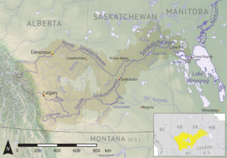
The Cub Hills are a hilly plateau located south-east of the geographical centre of the Canadian province of Saskatchewan. The hills are in the boreal forest ecozone of Canada and the landforms of the hills were shaped more than 10,000 years ago during last ice age. Throughout the Cub Hills, there are dozens of lakes and rivers and several parks. The Cubs Hills are 150 km (93 mi) north-east of Prince Albert and are in the Northern Saskatchewan Administration District and Census Division #18. Several highways criss-cross the plateau to provide access to the various parks and other amenities.
Saginas Lake, is a lake in the east-central part of the Canadian province of Saskatchewan in the boreal forest ecozone of Canada. It is located along the course of the Pepaw River and is situated in the Porcupine Hills. It is within Saskatchewan's Porcupine Provincial Forest and a portion of Porcupine Hills Provincial Park is on the eastern shore of the lake. Upstream along the Pepaw River is Pepaw and McBride Lakes—both of which lakes also have recreation sites that are part of Porcupine Hills Provincial Park. The lake and park are accessed from Highway 982, also known as Little Swan Road.
Parr Hill Lake, is a lake in the east-central part of the Canadian province of Saskatchewan in the boreal forest ecozone of Canada. It is part of the Swan River drainage basin and is situated in the Porcupine Hills and Saskatchewan's Porcupine Provincial Forest. A block of Porcupine Hills Provincial Park is on the north-eastern shore of the lake. The lake and park are accessed from Highway 982, which is also known as Little Swan Road.

Pepaw River, also spelt Peepaw, is a river in the east-central part of the Canadian province of Saskatchewan in the boreal forest ecozone of Canada. It begins in the Porcupine Hills and flows northward and meets up with the Etomami River south of the town of Hudson Bay. Much of the river is within Saskatchewan's Porcupine Provincial Forest and as such has various recreational opportunities along its course.
Piwei River is a river in the east-central part of the Canadian province of Saskatchewan in the boreal forest ecozone of Canada. It begins at the western end of the Porcupine Hills at Piwei Lakes and heads in an easterly direction through a glacier-formed valley and into the Etomami River, which is a tributary of the Red Deer River.
Midnight Creek is a river in the Canadian province of Saskatchewan. The river begins in the heart of the Porcupine Hills and of the Manitoba Escarpment and heads in a generally south-east direction through the Porcupine Provincial Forest before emptying into Elbow Lake. A short river connects Elbow Lake to Woody Lake, which is the source for Woody River. Highway 980 follows the river for much of its course.
Whitefish Lake is a lake in the Canadian province of Manitoba. It is on the western side of the province immediately east of the border with Saskatchewan in the Porcupine Hills of the Manitoba Escarpment. The lake is in Manitoba's Porcupine Provincial Forest, which is a boreal forest. Accessed is on the east side from Provincial Road 279.
Isbister Lake is a lake in the Canadian province of Saskatchewan. It is located in the east-central part of the province along the course of Midnight Creek in the Porcupine Hills and Porcupine Provincial Forest. The lake is in the Woody River Block of Porcupine Hills Provincial Park. Highway 980 provides access to the southern shore of the lake and its amenities. Isbister Lake is situated in boreal forest surrounded by hills, other small lakes, and muskeg.
Smallfish Lake is a lake in the Canadian province of Saskatchewan. It is located in the east-central part of the province right alongside the border with Manitoba in the Porcupine Hills and Porcupine Provincial Forest. The lake is part of the Woody River Block of Porcupine Hills Provincial Park and is situated in boreal forest surrounded by hills, other small lakes, and muskeg. Access to the lake is on the western side from Highway 980.
Spirit Lake is a lake in the Canadian province of Saskatchewan. It is located in the east-central part of the province in the Porcupine Hills and Porcupine Provincial Forest. The lake is part of the Woody River Block of Porcupine Hills Provincial Park and is situated in boreal forest surrounded by hills, other small lakes, and muskeg. Access to the lake is on the southern side from Spirit Lake Road which branches off Highway 980.

