Canada has a vast geography that occupies much of the continent of North America, sharing a land border with the contiguous United States to the south and the U.S. state of Alaska to the northwest. Canada stretches from the Atlantic Ocean in the east to the Pacific Ocean in the west; to the north lies the Arctic Ocean. Greenland is to the northeast with a shared border on Hans Island. To the southeast Canada shares a maritime boundary with France's overseas collectivity of Saint Pierre and Miquelon, the last vestige of New France. By total area, Canada is the second-largest country in the world, after Russia. By land area alone, however, Canada ranks fourth, the difference being due to it having the world's largest proportion of fresh water lakes. Of Canada's thirteen provinces and territories, only two are landlocked while the other eleven all directly border one of three oceans.
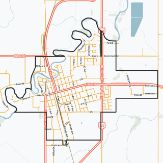
Swan River is a town in Manitoba, Canada. It is surrounded by the Municipality of Swan Valley West in the Swan River Valley region. According to the 2021 Canadian Census, Swan River had a population of 4,049, making it Manitoba's 18th largest in population.
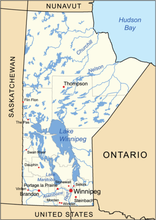
The geography of Manitoba addresses the easternmost of the three prairie Canadian provinces, located in the longitudinal centre of Canada. Manitoba borders on Saskatchewan to the west, Ontario to the east, Nunavut to the north, and the American states of North Dakota and Minnesota to the south. Although the border with Saskatchewan appears straight on large-scale maps, it actually has many right-angle corners that give the appearance of a slanted line. In elevation, Manitoba ranges from sea level on Hudson Bay to 2727 ft (831 m) on top of Baldy Mountain. The northern sixty percent of the province is on the Canadian Shield. The northernmost regions of Manitoba lie permafrost, and a section of tundra bordering Hudson Bay.

The Pembina Escarpment is a scarp that runs from South Dakota to Manitoba, and forms the western wall of the Red River Valley. The height of the escarpment above the river valley is 300–400 feet (91–122 m).

Duck Mountain Provincial Park is a 1,424 square kilometre provincial park in western Manitoba. The park is located within the larger and similarly named Duck Mountain Provincial Forest. Duck Mountain Provincial Park was designated a provincial park by the Government of Manitoba in 1961. and is considered to be a Class II protected area under the IUCN protected area management categories. The park is unincorporated, not lying within the borders of any of Manitoba's rural municipalities.

Highway 9 is a paved, undivided provincial highway in the Canadian province of Saskatchewan. It runs from North Dakota Highway 8 at the US border near Port of Northgate until it transitions into Provincial Road 283 at the Manitoba provincial boundary.
The Saskota Flyway is known as the International Road to Adventure, because it takes you from Hudson Bay, Saskatchewan, all the way south to Bismarck, North Dakota.
The Great Lakes-St. Lawrence Lowlands, or simply St. Lawrence Lowlands, is a physiographic region of Eastern Canada that comprises a section of southern Ontario bounded on the north by the Canadian Shield and by 3 of the Great Lakes — Lake Huron, Lake Erie and Lake Ontario — and extends along the St. Lawrence River to the Strait of Belle Isle and the Atlantic Ocean. The lowlands comprise three sub-regions that were created by intrusions from adjacent physiographic regions — the West Lowland, Central Lowland and East Lowland. The West Lowland includes the Niagara Escarpment, extending from the Niagara River to the Bruce Peninsula and Manitoulin Island. The Central Lowland stretches between the Ottawa River and the St. Lawrence River. The East Lowland includes Anticosti Island, Îles de Mingan, and extends to the Strait of Belle Isle.

The Boreal Plains Ecozone, as defined by the Commission for Environmental Cooperation (CEC), is a terrestrial ecozone in the western Canadian provinces of Manitoba, Saskatchewan and Alberta. It also has minor extensions into northeastern British Columbia and south-central Northwest Territories. The region extends over 779,471 km2, of which 58,981 km2 is conserved.
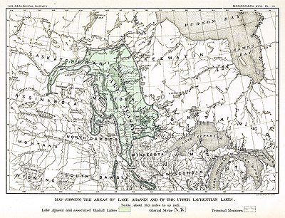
The Porcupine Hills refer to various groups of hills and uplands located in the prairie provinces of Canada, specifically the provinces of Saskatchewan and Manitoba. They are part of the Manitoba Escarpment, which was the shoreline of the ancient glacial Lake Agassiz. The hills are located north-west of Swan River, Manitoba, and are the headwaters of the Swan River. The highest elevation in the Porcupine Hills is Hart Mountain, at an elevation of 823 metres (2,700 ft), which makes it Manitoba's second-highest point. The Porcupine Provincial Forest surrounds the area.
The Shaw Brothers Lumber Company was a forestry company that had logging operations and sawmills along the Manitoba Escarpment.
The Porcupine Provincial Forest is a protected boreal forest in Canada which covers the Porcupine Hills on the border of Saskatchewan and Manitoba.
Hudson Bay Regional Park is a regional park in the Canadian province of Saskatchewan. It is located on the south side of the town of Hudson Bay in the RM of Hudson Bay No. 394 along the shores of the Red Deer River. The park is the site of a North West Company fur trading fort called Fort Red Deer River that was built in 1790. About 14 kilometres (8.7 mi) downstream, near Erwood, was a Hudson's Bay Company trading post that was built in 1757.

Red Deer River is a river in the Canadian provinces of Saskatchewan and Manitoba. It has its source at Nut Lake in east central Saskatchewan and from there, it flows east towards Manitoba where it empties into Dawson Bay of Lake Winnipegosis. To the north of Red Deer's basin is the Saskatchewan River, to the south-west is the upper Assiniboine River, and to the south-east is Swan River.
Pasquia Hills are hills in the Canadian province of Saskatchewan. They are located in the east central part of the province in the RM of Hudson Bay No. 394 near the Manitoba border. The hills are the northern most in a series of hills called the Manitoba Escarpment. The Manitoba Escarpment marks the western edge of the pre-historical glacial Lake Agassiz. The other four hills include Porcupine Hills, Duck Mountain, and Riding Mountain.
Fir River is a river in the Canadian province of Saskatchewan. The river's source is in the east central part of the province in the heart of the Pasquia Hills, which is one of four landforms that make up the Manitoba Escarpment. It flows in a southward direction until it meets up with the Red Deer River south of the town of Hudson Bay in Hudson Bay Regional Park. The river is in the boreal forest. Fir River is in the Nelson River drainage basin.
Woody River is a river in the Canadian provinces of Manitoba and Saskatchewan. The river's source is in the Porcupine Hills and Porcupine Provincial Forest of eastern Saskatchewan. From there it flows south through boreal forest and then east through Boreal Plains in the Parkland Region of Manitoba en route to Swan Lake. The river parallels the Swan River for much of its route as it travels through Swan River Valley between Duck Mountain and Porcupine Hills of the Manitoba Escarpment. Bowsman is the only notable community along the course of Woody River. Several highways cross it, including Saskatchewan's Highway 980, Manitoba's Roads 588, 587, 366, 268, and Manitoba's Highway 10.
Midnight Creek is a river in the Canadian province of Saskatchewan. The river begins in the heart of the Porcupine Hills and of the Manitoba Escarpment and heads in a generally south-east direction through the Porcupine Provincial Forest before emptying into Elbow Lake. A short river connects Elbow Lake to Woody Lake, which is the source for Woody River. Highway 980 follows the river for much of its course.
Whitefish Lake is a lake in the Canadian province of Manitoba. It is located on the western side of the province immediately east of the border with Saskatchewan in the Porcupine Hills of the Manitoba Escarpment. The lake is in Manitoba's Porcupine Provincial Forest, which is a boreal forest. Accessed is on the east side from Provincial Road 279.
Spirit Lake is a lake in the Canadian province of Saskatchewan. It is located in the east-central part of the province in the Porcupine Hills and Porcupine Provincial Forest. The lake is part of the Woody River Block of Porcupine Hills Provincial Park and is situated in boreal forest surrounded by hills, other small lakes, and muskeg. Access to the lake is on the southern side from Spirit Lake Road which branches off Highway 980.
Armit River is a river in the Canadian provinces of Manitoba and Saskatchewan in the Nelson River drainage basin. The river begins in the Porcupine Hills of the Manitoba Escarpment at Armit Lake and flows in a northerly direction closely following the Manitoba / Saskatchewan border and into Red Deer Lake along the course of the Red Deer River.