Related Research Articles
The Canadian Northern Railway (CNoR) was a historic Canadian transcontinental railway. At its 1923 merger into the Canadian National Railway, the CNoR owned a main line between Quebec City and Vancouver via Ottawa, Winnipeg, and Edmonton.

Northern Manitoba is a physical and cultural region of the Canadian province of Manitoba. Originally encompassing a small square around the Red River Colony, the province was extended north to the 60th parallel in 1912. The region's specific boundaries vary, as "northern" communities are considered to share certain social and geographic characteristics, regardless of latitude.

Duhamel is a hamlet in the central Alberta, Canada within Camrose County. It is located on Highway 21, approximately 100 kilometres (62 mi) southeast of Edmonton and 20 kilometres (12 mi) southwest of Camrose, Duhamel's closest major trading centre.

Henry Kelsey was an English fur trader, explorer, and sailor who played an important role in establishing the Hudson's Bay Company in Canada. Kelsey was born and married in East Greenwich, south-east of central London.

Fort Vermilion is a hamlet on the Peace River in northern Alberta, Canada, within Mackenzie County.
Highway 3 is a major provincial paved undivided highway in the Canadian province of Saskatchewan. It runs from the Alberta border, where it continues west as Alberta Highway 45, to the Manitoba border, and then continues east as Highway 77. Highway 3 is about 615 km (382 mi.) long. The CanAm Highway comprises Saskatchewan Highways 35, 39, 6, 3, as well as 2. 59.7 miles (96.1 km) of Saskatchewan Highway 3 contribute to the CanAm Highway between Melfort and Prince Albert.

The Rural Municipality of Hudson Bay No. 394 is a rural municipality (RM) in the Canadian province of Saskatchewan within Census Division No. 14 and SARM Division No. 4. At 12,462 square kilometres in area, it is the largest rural municipality in Saskatchewan. It is located in the northeast-central portion of the province.

The Manitoba Escarpment, or the Western Manitoba Uplands, are a range of hills along the Saskatchewan-Manitoba border. The eastern slopes of the range are considered to be a scarp. They were created by glacial scouring and formed the western shore of prehistoric Lake Agassiz.

Highway 9 is a paved, undivided provincial highway in the Canadian province of Saskatchewan. It runs from North Dakota Highway 8 at the US border near Port of Northgate until it transitions into Provincial Road 283 at the Manitoba provincial boundary.
The Saskota Flyway is known as the International Road to Adventure, because it takes you from Hudson Bay, Saskatchewan, all the way south to Bismarck, North Dakota.

Hudson Bay is a town in east-central Saskatchewan, Canada near the Manitoba border. The town is surrounded by the Rural Municipality of Hudson Bay No. 394.

Red Deer Lake is a lake in the Canadian province of Manitoba. The primary inflow and outflow is the Red Deer River. It is located in the west central part of the province, approximately 5 miles (8.0 km) north of Barrows and 10 miles (16 km) west of Dawson Bay, which is the north-west part of Lake Winnipegosis, and 8 miles (13 km) east of the Saskatchewan border.
Prairie River is a hamlet in the Canadian province of Saskatchewan. Listed as a designated place by Statistics Canada, the hamlet had a population of 35 in the Canada 2006 Census.
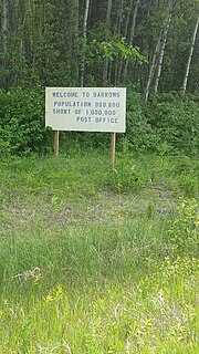
Barrows is a community in the Canadian province of Manitoba.
The Hudson Bay Railway (HBR) is a historic rail line in Manitoba, Canada to the shore of Hudson Bay. The venture began as a line between Winnipeg in the south and Churchill, and/or Port Nelson, in the north. However, HBR came to describe the final section between The Pas and Churchill.
The Red Deer Lumber Company was a forestry company that had approximately 10 logging operations along the Red Deer River, and owned and operated a sawmill on the south shore of Red Deer Lake.
The Shaw Brothers Lumber Company was a forestry company that had logging operations and sawmills along the Manitoba Escarpment.
Herman Finger was a lumberman who owned and operated various lumber companies that operated in Wisconsin, Minnesota, Ontario, Manitoba, and Saskatchewan. He also served as the first mayor of The Pas after its establishment in 1912.
The Pas Lumber Company was a forestry company that owned and operated several sawmills and logging operations in Manitoba, Saskatchewan, and British Columbia.

Hudson Bay Regional Park is a regional park in the Canadian province of Saskatchewan. It is located on the south side of the town of Hudson Bay in the RM of Hudson Bay No. 394 along the shores of the Red Deer River. The park is the site of a North West Company fur trading fort called Fort Red Deer River that was built in 1790. About 14 kilometres downstream, near Erwood, was a Hudson's Bay Company trading post that was built in 1757.
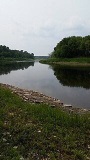
The Red Deer River is a river in the Canadian provinces of Saskatchewan and Manitoba. It has its source at Nut Lake in east central Saskatchewan and from there, it flows east towards Manitoba where it empties into Dawson Bay of Lake Winnipegosis. To the north of Red Deer's basin is the Saskatchewan River, to the south-west is the upper Assiniboine River, and to the south-east is Swan River.
References
- ↑ Canada 2006 Census: Designated places in Saskatchewan
- 1 2 3 Hudson Bay & District Cultural Society (1982). Valley Echoes: Life Along the Red Deer River Basin. Winnipeg, Manitoba: Inter-Collegiate Press.
- ↑ "Church Of God At Erwood Saskatchewan" . Retrieved 2015-07-15.
Places adjacent to Erwood, Saskatchewan | |
|---|---|
Coordinates: 52°51′25″N102°11′03″W / 52.85694°N 102.18417°W