Porcupine Hills Provincial Park is the newest provincial park in the Canadian Province of Saskatchewan. It was created in 2018 through the amalgamation of five pre-existing provincial recreation sites south-east of the town of Hudson Bay. The park is in the Porcupine Provincial Forest in the Porcupine Hills, which is a geographical feature in eastern Saskatchewan and western Manitoba. The hills are part of a range of hills called the Manitoba Escarpment.
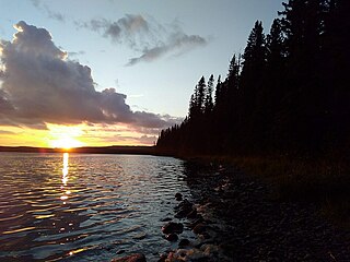
Greig Lake is a lake in Meadow Lake Provincial Park in the Canadian province of Saskatchewan in the boreal forest ecozone of Canada. On the eastern shore of the lake is the resort village of Greig Lake and Greig Lake Campground. The south-west corner of the lake has a resort called Waters Edge Eco Lodge. The lake is accessed from Highway 224 at the south end.
Matheson Lake is a lake in Meadow Lake Provincial Park in the Canadian Province of Saskatchewan in the boreal forest ecozone of Canada. The lake is located near the centre of the park, north of the Waterhen River, west of Vivian Lake and south of Peitahigan Lake. Several small streams feed into the lake and the outflow is at the southern shore, which feeds into the Waterhen River, a tributary of Beaver River. The Beaver River, in turn, flows north into Lac Île-à-la-Crosse and the Churchill River, a major tributary in the Hudson Bay drainage basin.
Peitahigan Lake is a lake in Meadow Lake Provincial Park in the Canadian Province of Saskatchewan in the boreal forest ecozone of Canada. The lake is one of six notable lakes in the Rusty Creek watershed. The other lakes include Rusty, First Mustus, Second Mustus, Third Mustus, and Fourth Mustus. Rusty Creek and the lakes are part of the Waterhen River drainage basin. The Waterhen River is a tributary of the Beaver River, which flows north into Lac Île-à-la-Crosse and the Churchill River, a major tributary in the Hudson Bay drainage basin.
Mistohay Lake is a lake in Meadow Lake Provincial Park in the Canadian Province of Saskatchewan in the boreal forest ecozone of Canada. The lake is part of the Waterhen River drainage basin. The Waterhen River is a tributary of the Beaver River, which flows north into Lac Île-à-la-Crosse and the Churchill River, a major tributary in the Hudson Bay drainage basin.
Lower Fishing Lake is a lake in the east-central part of the Canadian province of Saskatchewan in Narrow Hills Provincial Park. It is situated in the Cub Hills and the boreal forest ecozone of Canada. The lake is accessed from Highway 920, which connects to Hanson Lake Road and Highway 120. The Fishing Lakes Fire of 1977 burned much of the region upstream and around the lake and now the area is now dominated by jack pine, which is a tree species that is well adapted fire burned forests.
Baldy Lake is a lake in the east-central part of the Canadian province of Saskatchewan in Narrow Hills Provincial Park. It is situated in the Cub Hills and the boreal forest ecozone of Canada.
Pepaw Lake, also spelt Peepaw and Pee Paw, is a lake in the east-central part of the Canadian province of Saskatchewan in the boreal forest ecozone of Canada. There is a provincial park on the eastern shore of the lake, and it is located at the junction of Highway 983 and Highway 982, which is also known as Little Swan Road. Access to the lake and the park is from Little Swan Road.
Saginas Lake, is a lake in the east-central part of the Canadian province of Saskatchewan in the boreal forest ecozone of Canada. It is located along the course of the Pepaw River and is situated in the Porcupine Hills. It is within Saskatchewan's Porcupine Provincial Forest and a portion of Porcupine Hills Provincial Park is on the eastern shore of the lake. Upstream along the Pepaw River is Pepaw and McBride Lakes—both of which lakes also have recreation sites that are part of Porcupine Hills Provincial Park. The lake and park are accessed from Highway 982, also known as Little Swan Road.
Parr Hill Lake, is a lake in the east-central part of the Canadian province of Saskatchewan in the boreal forest ecozone of Canada. It is part of the Swan River drainage basin and is situated in the Porcupine Hills and Saskatchewan's Porcupine Provincial Forest. A block of Porcupine Hills Provincial Park is on the north-eastern shore of the lake. The lake and park are accessed from Highway 982, which is also known as Little Swan Road.

Pepaw River, also spelt Peepaw, is a river in the east-central part of the Canadian province of Saskatchewan in the boreal forest ecozone of Canada. It begins in the Porcupine Hills and flows northward and meets up with the Etomami River south of the town of Hudson Bay. Much of the river is within Saskatchewan's Porcupine Provincial Forest and as such has various recreational opportunities along its course.
Woody River is a river in the Canadian provinces of Manitoba and Saskatchewan. The river's source is in the Porcupine Hills and Porcupine Provincial Forest of eastern Saskatchewan. From there it flows south through boreal forest and then east through Boreal Plains in the Parkland Region of Manitoba en route to Swan Lake. The river parallels the Swan River for much of its route as it travels through Swan River Valley between Duck Mountain and Porcupine Hills of the Manitoba Escarpment. Bowsman is the only notable community along the course of Woody River. Several highways cross it, including Saskatchewan's Highway 980, Manitoba's Roads 588, 366, 268, and Manitoba's Highway 10.
Midnight Creek is a river in the Canadian province of Saskatchewan. The river begins in the heart of the Porcupine Hills and of the Manitoba Escarpment and heads in a generally south-east direction through the Porcupine Provincial Forest before emptying into Elbow Lake. A short river connects Elbow Lake to Woody Lake, which is the source for Woody River. Highway 980 follows the river for much of its course.
Woody Lake is a lake in the Canadian province of Saskatchewan. It is located in the east-central part of the province in the Porcupine Hills and Porcupine Provincial Forest. The entire lake is in the Woody River Block of Porcupine Hills Provincial Park. Highway 980 provides access to the lake.
Isbister Lake is a lake in the Canadian province of Saskatchewan. It is located in the east-central part of the province along the course of Midnight Creek in the Porcupine Hills and Porcupine Provincial Forest. The lake is in the Woody River Block of Porcupine Hills Provincial Park. Highway 980 provides access to the southern shore of the lake and its amenities. Isbister Lake is situated in boreal forest surrounded by hills, other small lakes, and muskeg.
Elbow Lake is a lake in the Canadian province of Saskatchewan. It is located in the east-central part of the province at the terminus of Midnight Creek in the Porcupine Hills and Porcupine Provincial Forest. The lake is in the Woody River Block of Porcupine Hills Provincial Park and is situated in boreal forest surrounded by hills, other small lakes, and muskeg. The small community of Elbow Lake is located at the north-west corner and Highway 980 provides access to it and the lake.
Smallfish Lake is a lake in the Canadian province of Saskatchewan. It is located in the east-central part of the province right alongside the border with Manitoba in the Porcupine Hills and Porcupine Provincial Forest. The lake is part of the Woody River Block of Porcupine Hills Provincial Park and is situated in boreal forest surrounded by hills, other small lakes, and muskeg. Access to the lake is on the western side from Highway 980.
Spirit Lake is a lake in the Canadian province of Saskatchewan. It is located in the east-central part of the province in the Porcupine Hills and Porcupine Provincial Forest. The lake is part of the Woody River Block of Porcupine Hills Provincial Park and is situated in boreal forest surrounded by hills, other small lakes, and muskeg. Access to the lake is on the southern side from Spirit Lake Road which branches off Highway 980.
Armit River is a river in the Canadian provinces of Manitoba and Saskatchewan in the Nelson River drainage basin. The river begins in the Porcupine Hills of the Manitoba Escarpment at Armit Lake and flows in a northerly direction closely following the Manitoba / Saskatchewan border and into Red Deer Lake along the course of the Red Deer River.
Overflowing River is a river in the Canadian provinces of Manitoba and Saskatchewan. It begins in Saskatchewan at Overflow Lake in the Pasquia Provincial Forest and flows in a generally eastward direction into Manitoba and then Lake Winnipegosis. The river traverses boreal forests and muskeg in the Boreal Plains Ecozone, moving from the Mid-Boreal Upland of the Pasquia Hills east to the Mid-Boreal Lowland.

