Swan River is a town in Manitoba, Canada. It is surrounded by the Municipality of Swan Valley West in the Swan River Valley region. According to the 2021 Canadian Census, Swan River had a population of 4,049, making it Manitoba's 18th largest in population.

Stirling Highway is, for most of its length, a four-lane single carriageway and major arterial road between Perth, Western Australia and the port city of Fremantle in Western Australia on the northern side of the Swan River. The speed limit is 60 km/h (37 mph). East of Crawley, it continues as Mounts Bay Road which links Crawley and the nearby University of Western Australia to the Perth central business district.
Provincial Trunk Highway 6 is a provincial primary highway located in the Canadian province of Manitoba. It runs from the Perimeter Highway of Winnipeg to the Thompson south city limits. It is also the main highway connecting Winnipeg to northern Manitoba. The speed limit is 100 km/h. The route is also used to deliver nickel from the Thompson mine to the Royal Canadian Mint in Winnipeg. The section of highway between its southern terminus near Winnipeg and the second junction with PTH 68 near Eriksdale is part of the Northern Woods and Water Route. The portion of the highway between Ponton and Thompson was known as Highway 391 prior to 1986.
Provincial Trunk Highway 31 is a provincial highway in the Canadian province of Manitoba. It is a short highway that runs from PTH 3 to the U.S. border where it becomes North Dakota State Highway 1. The entire highway lies within the Municipality of Pembina.
Highway 25 is a provincial highway in the Canadian province of Saskatchewan. It is 27 kilometres (17 mi) long and runs from Highway 2 in St. Louis to Highway 3 near Birch Hills. The highway is a gravel road except for small paved sections near the eastern and western terminuses.
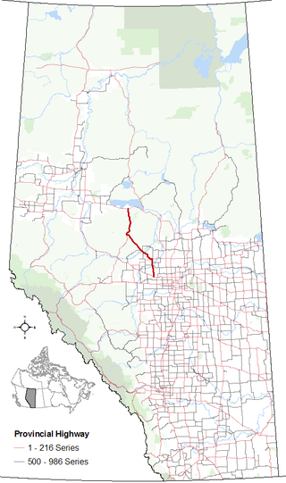
Alberta Provincial Highway No. 33, commonly referred to as Highway 33 and officially named Grizzly Trail, is a north–south highway in west–central Alberta, Canada.
King's Highway 129, commonly referred to as Highway 129, is a provincially maintained highway in the Canadian province of Ontario. Located in the Algoma and Sudbury districts, the highway extends for 221 kilometres (137 mi) from a junction with Highway 17 in Thessalon to the town of Chapleau, just north of Highway 101. The route is isolated and lightly travelled throughout its length; while providing access to several remote settlements, the only sizable communities along the route are the two termini. The highway was established in 1956 along the Chapleau Road. From the early 1960s to mid-1970s, Highway 129 was designated as the Chapleau Route of the Trans-Canada Highway.
Provincial Trunk Highway 10A is the name of four provincial primary highways located in the Canadian province of Manitoba. These highways are alternate routes of PTH 10, and each section was the original alignment of the parent highway. The four sections are located in Flin Flon, Swan River, Ethelbert, and Dauphin.

The Northern Woods and Water Route is a 2,400-kilometre (1,500 mi) route through northern British Columbia, Alberta, Saskatchewan and Manitoba in Western Canada. As early as the 1950s, community groups came together to establish a northern travel route; this was proposed as the Northern Yellowhead Transportation Route. The Northern Woods and Water Route Association was established in 1974, and encouraged promotion of the route with the promise of an increase in tourist travel. The route was designated in 1974 and is well signed throughout its component highways. The route starts at Dawson Creek as the Spirit River Highway and ends at the Perimeter of Winnipeg, Manitoba, after running through the northern regions of the western provinces. From west to east, the Northern Woods and Water Route (NWWR) incorporates portions of British Columbia Highway 49; Alberta Highways 49, 2A, 2, & 55; Saskatchewan Highways 55 & 9; Manitoba Provincial Road 283 and Trunk Highways 10, 5, 68 & 6. The halfway point of the NWWR is approximately at Goodsoil, Saskatchewan.
Highway 913 is a provincial highway in the Canadian province of Saskatchewan. It runs from Highway 120 to the Hanson Lake Road. The southern terminus of the highway is 9.9 kilometres (6.2 mi) north of Candle Lake Provincial Park, and the northern terminus is within the Narrow Hills Provincial Park and 15.2 kilometres (9.4 mi) north from the Narrow Hills Provincial Park campground area. It is about 65.1 kilometres (40.5 mi) long and connects with Highway 963 and has a concurrency with Highway 912 for 5 kilometres (3.1 mi). The highway is gravel for its whole length.
Highway 982, also known as Little Swan Road, is a provincial highway in the east central region of the Canadian province of Saskatchewan. It runs from Highway 8 to Highway 9 and is about 57 kilometres (35 mi) long.
Highway 9 is a paved, undivided provincial highway in the Canadian province of Saskatchewan. It runs from North Dakota Highway 8 at the US border near Port of Northgate until it transitions into Provincial Road 283 at the Manitoba provincial boundary.
The Saskota Flyway is known as the International Road to Adventure, because it takes you from Hudson Bay, Saskatchewan, all the way south to Bismarck, North Dakota.

North Carolina Highway 268 (NC 268) is a primary state highway in the U.S. state of North Carolina. It connects many communities as it traverses through the northwestern North Carolina mountains and foothills.
Highway 49 and Provincial Trunk Highway 49 is a provincial highway in the Canadian provinces of Saskatchewan and Manitoba. Most of the highway is in the east-central part of Saskatchewan and only a very short section is in Manitoba. It runs from Saskatchewan Highway 35 between the communities of Fosston and Hendon to the Saskatchewan — Manitoba border, before ending at Provincial Trunk Highway 83 south of the community of Benito. The combined highway is about 166.4 kilometres (103.4 mi) in length — 165.2 kilometres (102.7 mi) is in Saskatchewan and 1.2 kilometres (0.7 mi) is in Manitoba.
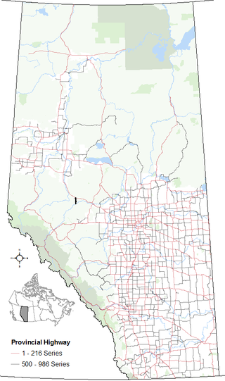
Alberta Provincial Highway No. 947, commonly referred to as Highway 947, is a designated north-south highway in northern Alberta, Canada that is partially constructed. Upon completion, the entire highway will span approximately 89 km (55 mi) from Highway 16 to Highway 43. The constructed portion of the highway consists of the final 20 km (12 mi) of the route from the Athabasca River to Highway 43.

Provincial Road 587 is a former provincial road in the Canadian province of Manitoba, that was paved with gravel.

Provincial Trunk Highway 83 is a major north-south highway that runs in the far western region of the Canadian province of Manitoba. It travels from the North Dakota border south of Melita, north through Virden, Birtle, Russell, and Roblin to its northern terminus with PTH 10 in the town of Swan River. Along with US 83, PTH 83 is part of a continuously numbered north-south highway in North America with a combined distance of 3,450 kilometres (2,140 mi).
The Swan River Valley is a valley between the Manitoba Escarpment in the Parkland Region of Manitoba, Canada. It is located between the Porcupine Hills to the northwest and Duck Mountains to the south, as well as Thunderhill to the west and Lake Winnipegosis to the east.

Provincial Road 275, known locally as Ditch Road, is a provincial road in the Canadian province of Manitoba. It is paved for its entire length.
Woody River is a river in the Canadian provinces of Manitoba and Saskatchewan. The river's source is in the Porcupine Hills and Porcupine Provincial Forest of eastern Saskatchewan. From there it flows south through boreal forest and then east through Boreal Plains in the Parkland Region of Manitoba en route to Swan Lake. The river parallels the Swan River for much of its route as it travels through Swan River Valley between Duck Mountain and Porcupine Hills of the Manitoba Escarpment. Bowsman is the only notable community along the course of Woody River. Several highways cross it, including Saskatchewan's Highway 980, Manitoba's Roads 588, 587, 366, 268, and Manitoba's Highway 10.
