Rural Municipality of Mountain

Last updated

Mountain
Rural Municipality of Mountain
CAN MB Mountain.svg
Location of the Rural Municipality of Mountain in Manitoba
Coordinates: 52°16′27″N100°36′30″W / 52.27417°N 100.60833°W / 52.27417; -100.60833 Coordinates: 52°16′27″N100°36′30″W / 52.27417°N 100.60833°W / 52.27417; -100.60833
CountryCanada
Province Manitoba
Region Parkland
Incorporated as an LGD January 1, 1945 (1945-01-01)
Incorporated as an RM January 1, 1997 (1997-01-01)
Government
   Reeve Robert Hanson
Area
  Land2,607.77 km2 (1,006.87 sq mi)
Population
 (2016)
  Total978
Website rmofmountain.com

The Rural Municipality of Mountain is a rural municipality (RM) in the Parkland Region of Manitoba, western Canada.

Contents

Its 2,607 square kilometres (1,007 sq mi) is split geographically into two large sections—Mountain (North) at 52°34′48″N101°00′54″W / 52.58000°N 101.01500°W / 52.58000; -101.01500 , and Mountain (South) at 51°58′21″N100°23′31″W / 51.97250°N 100.39194°W / 51.97250; -100.39194 —separated by approximately 10 km (6.2 mi) at the northeast corner of Municipality of Minitonas – Bowsman. [1]

The municipality, which was named for the nearby Porcupine and Duck Mountains, [2] sits along the east side of both the Porcupine Provincial Forest in the north and the Duck Mountain Provincial Forest in the south. [1]

Its largest communities are the local urban districts of Pine River, Birch River, and Mafeking. [1]

Communities

The constituent communities of the Rural Municipality of Mountain include the following. [1] [3] [2]

Mountain (South): [1]

Mountain (North): [1]

Demographics

North part

In the 2021 Census of Population conducted by Statistics Canada, the north portion of the RM of Mountain had a population of 537 living in 257 of its 297 total private dwellings, a change of

South part

In the 2021 Census of Population conducted by Statistics Canada, the south portion of the RM of Mountain had a population of 443 living in 187 of its 250 total private dwellings, a change of

Combined

In the 2021 Census of Population conducted by Statistics Canada, the RM of Mountain had a combined population of 980 living in 444 of its 547 total private dwellings, a change of

Related Research Articles

<span class="mw-page-title-main">Rural Municipality of Rosser</span> Rural municipality in Manitoba, Canada

Rosser is a rural municipality (RM) in the Canadian province of Manitoba, lying adjacent to the northwest side of Winnipeg and part of the Winnipeg Metro Region. Its population as of the 2016 Census was 1,372.

<span class="mw-page-title-main">Benito, Manitoba</span> Unincorporated urban community in Manitoba, Canada

Benito is an unincorporated urban community in the Municipality of Swan Valley West, Manitoba, Canada.

Birch River is a local urban district in the northern portion of the Rural Municipality of Mountain, Manitoba, Canada. It is around 40 kilometers from Swan River, Manitoba.

<span class="mw-page-title-main">Rural Municipality of St. Clements</span> Rural municipality in Manitoba, Canada

St. Clements is a rural municipality in Manitoba, Canada. It is located to the north-east of Winnipeg, stretching from East St. Paul and Birds Hill Provincial Park in the south to Lake Winnipeg and Grand Beach Provincial Park to the north. The Red River demarcates the western boundary of the municipality. St. Clements contains the communities of East Selkirk, and Lockport east of the Red River. It almost completely surrounds the Brokenhead 4 Indian reserve, with the exception of a small lakefront on Lake Winnipeg.

<span class="mw-page-title-main">Rural Municipality of Sarnia No. 221</span> Rural Municipality in Saskatchewan, Canada

The Rural Municipality of Sarnia No. 221 is a rural municipality (RM) in the Canadian province of Saskatchewan within Census Division No. 6 and SARM Division No. 2. It is located in the south-central portion of the province.

<span class="mw-page-title-main">Rural Municipality of Cartier</span> Rural municipality in Manitoba, Canada

Rural Municipality of Cartier is a rural municipality in the Central Plains and Metro Regions of Manitoba, Canada. The municipality is bordered on the west by the RM of Portage la Prairie, to the east by the RM of Headingley, and to the north by the Assiniboine River. It is mainly flat rich farmland. Its main town is Elie.

<span class="mw-page-title-main">Division No. 14, Saskatchewan</span> Census division in Saskatchewan in Canada

Division No. 14 is one of eighteen census divisions in the province of Saskatchewan, Canada, as defined by Statistics Canada. It is located on the northern portion of Southeast Saskatchewan, bordering Manitoba. The most populous community in this division is the city of Melfort. Other important communities are the towns of Nipawin and Tisdale.

<span class="mw-page-title-main">Rural Municipality of Porcupine No. 395</span> Rural Municipality in Saskatchewan, Canada

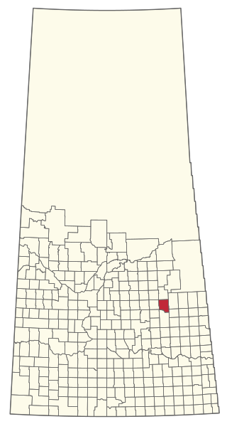
The Rural Municipality of Porcupine No. 395 is a rural municipality (RM) in the Canadian province of Saskatchewan within Census Division No. 14 and SARM Division No. 4. It is located in the northeast-central portion of the province.

<span class="mw-page-title-main">Rural Municipality of Montcalm</span> Rural municipality in Manitoba, Canada

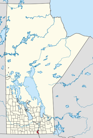
Montcalm is a rural municipality (RM) in the province of Manitoba in Western Canada. The Canada 2016 Census reported a population of 1,260 persons, a decrease from the 1,309 reported in the 2011 Census.

<span class="mw-page-title-main">Rural Municipality of Stanley</span> Rural municipality in Manitoba, Canada

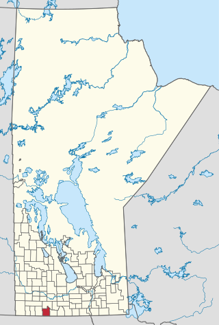
Stanley is a rural municipality (RM) in the province of Manitoba in Western Canada. It is located in the southern part of the province, along its border with the state of North Dakota in the United States. Since 1876, the area made up part of the Mennonite West Reserve. The municipality has a population of 8,969 as of the 2016 Canada Census. The cities of Winkler and Morden lie geographically within the municipality but are separate urban municipalities.

<span class="mw-page-title-main">Municipality of Killarney-Turtle Mountain</span> Rural municipality in Manitoba, Canada

Killarney-Turtle Mountain is a rural municipality (RM) located in the Westman Region of Manitoba, Canada. It is located to the immediate north of the Canada–United States border opposite Rollete and Towner Counties, North Dakota.

<span class="mw-page-title-main">Rural Municipality of Hazel Dell No. 335</span> Rural Municipality in Saskatchewan, Canada

The Rural Municipality of Hazel Dell No. 335 is a rural municipality (RM) in the Canadian province of Saskatchewan within Census Division No. 9 and SARM Division No. 4.

<span class="mw-page-title-main">Rural Municipality of Sasman No. 336</span> Rural Municipality in Saskatchewan, Canada

The Rural Municipality of Sasman No. 336 is a rural municipality (RM) in the Canadian province of Saskatchewan within Census Division No. 10 and SARM Division No. 4.

<span class="mw-page-title-main">Rural Municipality of Livingston No. 331</span> Rural Municipality in Saskatchewan, Canada

The Rural Municipality of Livingston No. 331 is a rural municipality (RM) in the Canadian province of Saskatchewan within Census Division No. 9 and SARM Division No. 4.

<span class="mw-page-title-main">Municipality of Deloraine – Winchester</span> Rural municipality in Manitoba, Canada

The Municipality of Deloraine – Winchester is a rural municipality (RM) in the Canadian province of Manitoba.

<span class="mw-page-title-main">Municipality of Harrison Park</span> Rural municipality in Manitoba, Canada

The Municipality of Harrison Park is a rural municipality (RM) in the Canadian province of Manitoba that incorporated on January 1, 2015 via the amalgamation of the RMs of Harrison and Park. It was formed as a requirement of The Municipal Amalgamations Act, which required that municipalities with a population less than 1,000 amalgamate with one or more neighbouring municipalities by 2015. The Government of Manitoba initiated these amalgamations in order for municipalities to meet the 1997 minimum population requirement of 1,000 to incorporate a municipality.

<span class="mw-page-title-main">Municipality of McCreary</span> Rural municipality in Manitoba, Canada

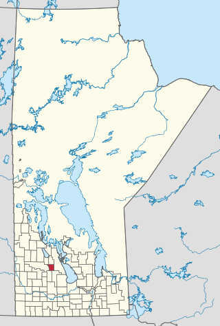
The Municipality of McCreary is a rural municipality (RM) in the Parkland Region of Manitoba, Canada.

<span class="mw-page-title-main">Rural Municipality of Riding Mountain West</span> Rural municipality in Manitoba, Canada

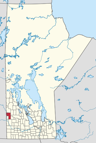
The Rural Municipality of Riding Mountain West is a rural municipality (RM) in the Canadian province of Manitoba. It is located in Manitoba's Parkland region, between Riding Mountain National Park near the province's western border with Saskatchewan.

<span class="mw-page-title-main">Riverdale Municipality</span> Rural municipality in Manitoba, Canada

Riverdale Municipality is a rural municipality (RM) in the Canadian province of Manitoba.

References

  1. 1 2 3 4 5 6 "History". RM of Mountain. Retrieved August 5, 2021.
  2. 1 2 "Manitoba Communities: Mountain (Rural Municipality)". www.mhs.mb.ca. Retrieved August 5, 2021.
  3. "Home". RM of Mountain. Retrieved August 5, 2021.
  4. 1 2 3 "Population and dwelling counts: Canada, provinces and territories, and census subdivisions (municipalities), Manitoba". Statistics Canada. February 9, 2022. Retrieved February 20, 2022.