Rural Municipality of West St. Paul

Last updated

West St. Paul
RM of West St. Paul Municipal Hall.jpg
RM of West St. Paul Municipal Hall
CAN MB West St. Paul.svg
Location of the RM of West St. Paul in Manitoba
Coordinates: 50°00′43″N97°06′54″W / 50.01194°N 97.11500°W / 50.01194; -97.11500
CountryCanada
Province Manitoba
Region Winnipeg Metro
Founded1888
Established1915
Government
  MayorPeter Truijen
  MLA Jasdeep Devgan
  MP Raquel Dancho
Area
[1]
  Total87.49 km2 (33.78 sq mi)
Elevation
[2]
229 m (751 ft)
Population
 (2021) [3]
  Total6,682
  Density76/km2 (200/sq mi)
Time zone UTC−6 (CST)
  Summer (DST) UTC−5 (CDT)
Forward Sortation Area
R4A
Area codes Area codes 204 and 431
Website weststpaul.com

West St. Paul is a rural municipality (RM) in Manitoba, Canada. It lies adjacent to the north side of Winnipeg, and directly west of the Red River. It is part of the Winnipeg Metro Region, and had a population of 5,368 at the 2016 census.

Contents

It contains two communities, Middlechurch and Rivercrest. Middlechurch is the larger of the two communities and includes the municipal hall, cemetery, curling club, fire station, St. Paul's church, the Middlechurch Home of Winnipeg, and Grassmere Creek all lie at the southern portion of the municipality.

The community of Rivercrest lies to the north and contains the West St. Paul School and Royal Manitoba Yacht Club.

History

West St. Paul was formed on 3 November 1915 when the municipality of St. Paul (1888-1914) was subdivided into West St. Paul and East St. Paul. [4]

Demographics

In the 2021 Census of Population conducted by Statistics Canada, West St. Paul had a population of 6,682 living in 2,228 of its 2,270 total private dwellings, a change of

Panethnic groups in the Rural Municipality of West St. Paul (2001−2021)
Panethnic group2021 [6] 2016 [7] 2011 [8] 2006 [9] 2001 [10]
Pop. %Pop.%Pop.%Pop.%Pop.%
European [lower-alpha 1] 4,8254,2454,0453,8103,625
Indigenous 685470370160130
South Asian 4952151009530
Southeast Asian [lower-alpha 2] 250145852050
African 10535403045
Latin American 3500020
East Asian [lower-alpha 3] 202015500
Middle Eastern [lower-alpha 4] 2002500
Other/multiracial [lower-alpha 5] 6025000
Total responses6,4855,1454,6854,1653,890
Total population6,6825,3684,9324,3574,085
Note: Totals greater than 100% due to multiple origin responses

Municipal Hall

The two-story municipal hall was built in 1917 and expanded with a North and South addition in 1989. [11] It is considered a municipally-designated historic landmark of Manitoba and currently the only official historic site within West St. Paul. [11]

Municipal services

Water

Water services are provided by the Cartier Regional Water Co-Op via the Headingley Water Treatment Plant. From there the CentrePort distribution line serves Rosser Reservoir, the Rural Municipality of Rosser and the CentrePort development. Further northeast is the West St. Paul Reservoir which serves the RM. [12]

Fire Department

The West St. Paul Fire Department is not a full-time fire department, but rather a paid-on-call department, meaning firefighters are paid only for the emergency calls and training that they attend. The department's fire coverage area encompasses the entire municipality of West St. Paul or 87.66 km2 (33.85 sq mi). The department responds to a variety of emergency situations including but not limited to fire response, medical response, motor vehicle collisions, Carbon Monoxide alarms, downed power lines and water rescue response. The department responded to a total of 264 calls for service in 2013.

The West St. Paul Fire Department's current organizational structure consists of 1 Fire Chief, 1 Deputy Fire Chief, 3 Captains, 2 Lieutenants, 1 training officer, and 24 firefighters. The department has a total of 32 members.

The department currently has seven vehicles and one boat it uses to respond to calls for service including two pumper engines, two water tankers, one rescue/command truck, two squad and one zodiac boat for water rescue response.[ citation needed ]

Curling Club

The West St. Paul curling club was built and has been in operation since 1963. It received some notoriety in 2015, when team Reid Carruthers, from the West St. Paul club, won the Men's Manitoba Curling Provincials and placed third in the Men's National Brier [13] [14]

St. Paul's Anglican Church

Established in January 1825, St. Paul's Anglican Church was built in order to keep up with the growing population along the Red River. [15] The structure of the church was rebuilt in 1844 and again in 1878 as result of damage due to flooding. The Historic Sites Advisory Board of Manitoba erected a plaque in 1975 owing to its historical importance, however it is not yet listed as a historic site in Manitoba. Prior to becoming a municipality, the region surrounding the church was known as the parish of St. Paul's or parish of the middle church (middle owing to its being situated between the older St. John's Cathedral ("upper church") and St. Andrews-on-the-Red ("lower church")). Thus the church and parish provided a name to both the municipality as well as the nearby community.[ citation needed ]

West St. Paul School

West St. Paul has one school is a kindergarten to grade 8 school that was built in 1947, expanded in 1953 and expanded again in 1959. [11] Prior to building the school, classes were held at a local church (K to 3) as well as the municipal hall (grades 4 and up). In 1959, it joined the newly formed Seven Oaks School Division. Its current capacity is 600 students. [11]

Notes

  1. Statistic includes all persons that did not make up part of a visible minority or an indigenous identity.
  2. Statistic includes total responses of "Filipino" and "Southeast Asian" under visible minority section on census.
  3. Statistic includes total responses of "Chinese", "Korean", and "Japanese" under visible minority section on census.
  4. Statistic includes total responses of "West Asian" and "Arab" under visible minority section on census.
  5. Statistic includes total responses of "Visible minority, n.i.e." and "Multiple visible minorities" under visible minority section on census.

Related Research Articles

<span class="mw-page-title-main">Weyburn</span> City in Saskatchewan, Canada

Weyburn is the tenth-largest city in Saskatchewan, Canada. The city has a population of 11,019. It is on the Souris River 110 kilometres (68 mi) southeast of the provincial capital of Regina and is 70 kilometres (43 mi) north from the North Dakota border in the United States. The name is reputedly a corruption of the Scottish "wee burn," referring to a small creek. The city is surrounded by the Rural Municipality of Weyburn No. 67.

<span class="mw-page-title-main">Winnipeg North</span> Federal electoral district in Manitoba, Canada

Winnipeg North is a federal electoral district in Canada that has been represented in the House of Commons of Canada since 1917. It covers the northern portion of Winnipeg, Manitoba.

<span class="mw-page-title-main">Selkirk, Manitoba</span> City in Manitoba, Canada

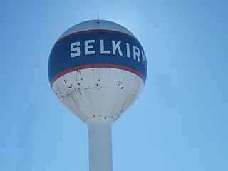
Selkirk is a city in the western Canadian province of Manitoba, located on the Red River about 22 kilometres (14 mi) northeast of Winnipeg, the provincial capital. It has a population of 10,504 as of the 2021 census.

<span class="mw-page-title-main">Elmwood—Transcona</span> Federal electoral district in Manitoba, Canada

Elmwood—Transcona is a federal electoral district in Manitoba, Canada, that has been represented in the House of Commons of Canada since 1988. Its population in 2011 was 85,906.

<span class="mw-page-title-main">Kildonan—St. Paul</span> Federal electoral district in Manitoba, Canada

Kildonan—St. Paul is a federal electoral district in the Winnipeg Capital Region of Manitoba, Canada. It has been represented in the House of Commons of Canada since 2004.

<span class="mw-page-title-main">Niverville, Manitoba</span> Place in Manitoba, Canada

Niverville is a town in the Eastman Region, Manitoba, Canada. The town lies between the northwest corner of the Rural Municipality of Hanover and the southeastern portion of the Rural Municipality of Ritchot. Niverville's population as of the 2021 census is 5,947, the largest town and 10th-largest community in Manitoba.

<span class="mw-page-title-main">Charleswood—St. James—Assiniboia—Headingley</span> Federal electoral district in Manitoba, Canada

Charleswood—St. James—Assiniboia—Headingley is a federal electoral district in Manitoba, Canada, that has been represented in the House of Commons of Canada since 1997.

<span class="mw-page-title-main">Winnipeg Metropolitan Region</span> Metropolitan area in Manitoba, Canada

The Winnipeg Metropolitan Region is a metropolitan area in the Canadian province of Manitoba located in the Red River Valley in the southeast portion of the province of Manitoba, Canada. It contains the provincial capital of Winnipeg and 17 surrounding rural municipalities, cities, and towns.

<span class="mw-page-title-main">Rural Municipality of Hanover</span> Rural municipality in Manitoba, Canada

The Rural Municipality of Hanover is a rural municipality (RM) in southeastern Manitoba, Canada, located southeast of Winnipeg in Division No. 2.

<span class="mw-page-title-main">Rural Municipality of East St. Paul</span> Rural municipality in Manitoba, Canada

East St. Paul is a rural municipality (RM) in Manitoba, Canada. It is located north-east of and adjacent to the city of Winnipeg, and is part of the Winnipeg Metropolitan Area. The municipality was formed on 3 November 1915 when the municipality of St. Paul (1888-1914) was subdivided into West St. Paul and East St. Paul, with the Red River acting as the dividing line.

<span class="mw-page-title-main">Rural Municipality of St. Andrews</span> Rural municipality in Manitoba, Canada

St. Andrews is a rural municipality (RM) in Manitoba, Canada. It lies west of the Red River; its southern border is approximately 8 kilometres (5.0 mi) north of Winnipeg.

<span class="mw-page-title-main">Rural Municipality of St. Clements</span> Rural municipality in Manitoba, Canada

St. Clements is a rural municipality (RM) in Manitoba, Canada. It is located to the north-east of Winnipeg, stretching from East St. Paul and Birds Hill Provincial Park in the south to Lake Winnipeg and Grand Beach Provincial Park to the north. The Red River demarcates the western boundary of the municipality. St. Clements contains the communities of East Selkirk, and Lockport east of the Red River. It almost completely surrounds the Brokenhead 4 Indian reserve, with the exception of a small lakefront on Lake Winnipeg.

<span class="mw-page-title-main">Stonewall, Manitoba</span> Town in Manitoba, Canada

Stonewall is a town in the Canadian province of Manitoba with a population of 5,046 as of the 2021 census. The town is situated approximately 25 kilometres (16 mi) north of Winnipeg on PTH 67. It is known for its limestone quarries. The local festival is the Quarry Days which is usually held over three days in August on Main Street. The town is surrounded by the R.M. of Rockwood.

<span class="mw-page-title-main">Rural Municipality of Taché</span> Rural municipality in Manitoba, Canada

Taché is a rural municipality in Manitoba, Canada, incorporated in 1880.

<span class="mw-page-title-main">Rural Municipality of Springfield</span> Rural municipality in Manitoba, Canada

Springfield is a rural municipality (RM) in Manitoba, Canada. It stretches from urban industrial development on the eastern boundary of the city of Winnipeg, through urban, rural residential, agricultural and natural landscapes, to the Agassiz Provincial Forest on the municipality's eastern boundary. Birds Hill Provincial Park nestles into the north-western corner of Springfield.

<span class="mw-page-title-main">Rural Municipality of Ritchot</span> Rural municipality in Manitoba, Canada

The Rural Municipality of Ritchot is a rural municipality (RM) in the Winnipeg Capital Region, bordering the south side of Winnipeg in Manitoba, Canada. The separately-administered town of Niverville lies adjacent to its southeast, between it and the Rural Municipality of Hanover.

<span class="mw-page-title-main">Rural Municipality of Macdonald</span> Rural Municipality in Southern Manitoba

Macdonald is a rural municipality lying adjacent to the southwest side of Winnipeg, Manitoba, Canada. It is part of the Winnipeg Metro Region, but is not part of the smaller Winnipeg census metropolitan area. Macdonald's population as of the 2016 census was 7,162.

<span class="mw-page-title-main">Rural Municipality of Rockwood</span> Rural Municipality in Manitoba, Canada

Rockwood is a rural municipality (RM) lying north of Winnipeg, Manitoba, Canada. It is part of the Winnipeg Metro Region and had a 2021 census population of 8,440. The independently governed towns of Stonewall and Teulon are both enclaved within Rockwood.

<span class="mw-page-title-main">Demographics of Manitoba</span>

Manitoba is one of Canada's 10 provinces. It is the easternmost of the three Prairie provinces.

<span class="mw-page-title-main">Rural Municipality of Portage la Prairie</span> Rural municipality in Manitoba, Canada

Portage la Prairie is a rural municipality (RM) in the province of Manitoba in Western Canada. It surrounds the city of Portage la Prairie, Manitoba's fifth-largest city. Also within the borders of the municipality are the Dakota Plains First Nation and most of the Long Plain First Nation Indian reserves.

References

  1. "2016 Census Profile - West St. Paul". statcan.gc.ca. Ottawa: Statistics Canada. 29 November 2017. Retrieved 25 December 2019.
  2. "Elevation at RM of West St. Paul". earthtools.org. Retrieved 25 December 2019.
  3. "2021 Census Profile - West St. Paul". Statistics Canada . Ottawa. Retrieved 30 March 2023.
  4. "Manitoba Municipalities: St. Paul". Manitoba Historical Society: Historic Places in Manitoba. Manitoba Historical Society. Retrieved 16 October 2015.
  5. "Population and dwelling counts: Canada, provinces and territories, and census subdivisions (municipalities), Manitoba". Statistics Canada. 9 February 2022. Retrieved 20 February 2022.
  6. Government of Canada, Statistics Canada (26 October 2022). "Census Profile, 2021 Census of Population". www12.statcan.gc.ca. Retrieved 2 June 2024.
  7. Government of Canada, Statistics Canada (27 October 2021). "Census Profile, 2016 Census". www12.statcan.gc.ca. Retrieved 2 June 2024.
  8. Government of Canada, Statistics Canada (27 November 2015). "NHS Profile". www12.statcan.gc.ca. Retrieved 2 June 2024.
  9. Government of Canada, Statistics Canada (20 August 2019). "2006 Community Profiles". www12.statcan.gc.ca. Retrieved 2 June 2024.
  10. Government of Canada, Statistics Canada (2 July 2019). "2001 Community Profiles". www12.statcan.gc.ca. Retrieved 2 June 2024.
  11. 1 2 3 4 "West St. Paul Municipal Hall". Canada's Historic Places: A Federal, Provincial, and Territorial Collaboration. Parks Canada. Retrieved 16 October 2015.
  12. "Cartier Regional Water Co-op: Public Water System: Annual Report 2018" (PDF). crwc.ca. 28 March 2019. pp. 3–4, 7–8. Retrieved 11 February 2020.
  13. Saelhof, Todd (4 March 2015). "Team Manitoba third Braeden Moskowy used to curling success in Calgary". Calgary Sun. Retrieved 16 October 2015.
  14. Wiecek, Paul (2 September 2015). "Manitoba's new kings of the rings: Carruthers' upset win another demoralizing blow to McEwen". Winnipeg Free Press. Retrieved 16 October 2015.
  15. "Historic Sites of Manitoba: St. Paul's Anglican Church and Cemetery". Manitoba Historical Society: Historic Places in Manitoba. Manitoba Historical Society. Retrieved 16 October 2015.