Birds Hill

Last updated
Birds Hill
Unincorporated municipality
Silverfox Estates.jpg
Homes along Silverfox Estates in Birds Hill.
Canada Manitoba location map 2.svg
Red pog.svg
Birds Hill
Coordinates: 49°58′30″N97°00′19″W / 49.97500°N 97.00528°W / 49.97500; -97.00528 Coordinates: 49°58′30″N97°00′19″W / 49.97500°N 97.00528°W / 49.97500; -97.00528
Rural Municipality East St. Paul
Founded byJames Curtis Bird

Birds Hill is an unincorporated community in the Canadian province of Manitoba located a few kilometers northeast of Winnipeg, Manitoba, in the Rural Municipality of East St. Paul. The community is a few kilometers east of the Red River The R.M. of East St. Paul's Administration and Finance Departments, Fire Department, municipal council chambers, and RCMP offices are located in Birds Hill. The community includes Silverfox Estates and the Country Villas, which is Manitoba's first resort age-restricted adult-only gated community. Built in 1998, this residential area is an exclusively low-density community where 163 detached, single-family homes are on private landscaped sites. [1]

Contents

Geography

A portion of the community is located on top of a hill formed during the last ice age by a glacial sand deposit, or esker. These sand ridges are some of the highest elevations in south-central Manitoba. The hills in the area were a place for settlers and native peoples to escape to when fleeing high floodwaters along the Red River valley. Birds Hill Park is located on the same ridge of sand eskers as Birds Hill but at the other end of them. A large property in the area was owned by James Curtis Bird after whom the area is named, [2] was a fur trader, chief factor of the Lower Red River district in 1821 and one time governor of Assiniboia. [3] His son, Curtis James Bird a Canadian doctor, politician, and Speaker of the Manitoba Legislative Assembly from 1873 to 1874 inherited the property from his father. [4]

History

The gravel business led to the rapid settlement of Birds Hill. Canadian Pacific Railway first dug the quarry at Birds Hill in the 1870s to provide ballast for the transcontinental railway. The City of Winnipeg purchased the quarry later and used the gravel for everything from building roads and house foundations to filling sandbags. Hundreds of people were employed in the quarry at one time. The pit was owned by numerous others before the Swiston family's company called Birds Hill Gravel and Stone last operated it. After the pits could no longer be used for mining gravel, the Swiston family undertook rehabilitation in 1983 with the sloping of the banks and the development of a walkway in preparation for the Silverfox housing subdivision that would overlook part of the area. The Swiston family was able to obtain small funding grants, but 90% of the funding came from Birds Hill gravel and Stone's profits. [5] The dug out quarry has since been reclaimed as Silver Springs Park with homes along part of its perimeter.

In 1914, a two-storey brick school was constructed on Lot 95 on Birds Hill Road. The foundation stone was laid on 22 May 1914 by Deputy Minister of Education Robert Fletcher. The two-room facility was built by contractor Walter Owens that expanded with two additional classrooms approved by local voters in two months of the school's opening that cost a further $3,000. As of 1984, the school had three classrooms with four portable classrooms on-site, two of which were used as a gymnasium and library. The building was put up for sale and demolished in March 1987. The site is now a Sobeys. [6] Built in 1985 and 1986 at the corner of Hoddinott Road and Raleigh Street, the Birds Hill Elementary School added capacity to the River East School Division, replacing the original Birds Hill School. It opened for the 1986-1987 school year. The old school’s name stone and cornerstone have been retained on the present school. [7]

A monument in Memorial Park in Birds Hill was dedicated originally on 13 September 1925 by Rev. R. W. Ridgeway of St. Thomas’ Anglican Church and Rev. J. W. McAlpine of Bird’s Hill United Church commemorates residents killed during military service. It was unveiled before a crowd of around 100, including families of the fallen, along with East St. Paul Reeve W. J. Dawson and Councillors, Police Magistrate W. G. Scott, ex-Reeve A. E. Sperring, municipal Secretary-Treasurer W. Gorham and R. D. Waugh. [8]

Silverfox Estates is named after a large silver fox fur ranch which from 1922 to 1970 raised silver foxes there as a source of fur. [9]

Recreation

Families tobogganing at Birds Hill. Tobogganing at Birds Hill.jpg
Families tobogganing at Birds Hill.

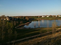
Silver Springs Park, renamed Swiston Family Heritage Park in 2020, is described as a hidden gem in East St. Paul, little known outside the municipality. A quarry was dug out of one of the largest hills in the area, and rehabilitated into a municipal park. The park is a vast space. The excavation site is about 73 hectares and the south bank is 21 meters deep. The Swistun family leveled the quarry bottom and sloped the sides so they wouldn't be a danger. They had topsoil hauled into the quarry and planted native grasses and more than 1,200 trees and shrubs. They also built a causeway to an island on the lake. Inland Aggregates assisted with the rehabilitation. [10] It started to look like a park by the 1990s. There was never a grand opening. It just slowly evolved. The park is a staging area for both the Trans Canada Trail, which runs through it, and the floodway's non-motorized recreation trail, called the Duff Roblin Parkway Trail. People canoe and kayak on the quarry lake. The vegetation is an oak-aspen mix, including pin cherry and chokecherry bushes, and even horsetail, a plant species 100 million years old. There are plenty of birds, including geese, ducks, songbirds, swallows, and sandpipers. The south slope is a popular tobogganing site in winter. The municipality also clears an ice-skating trail.

See also

Related Research Articles

Tourism in Canada Overview of tourism in Canada

Canada has a large domestic and foreign tourism industry. The second largest country in the world, Canada's incredible geographical variety is a significant tourist attractor. Much of the country's tourism is centred in the following regions: Toronto, Montreal, Quebec City, Vancouver/Whistler, Niagara Falls, Vancouver Island, Canadian Rockies, British Columbia's Okanagan Valley, Churchill, Manitoba and the national capital region Ottawa. The large cities are known for their culture, diversity, as well as the many national parks and historic sites.

Gravel pit

A gravel pit is an open-pit mine for the extraction of gravel. Gravel pits often lie in river valleys where the water table is high, so they may naturally fill with water to form ponds or lakes. Old, abandoned gravel pits are normally used either as nature reserves, or as amenity areas for water sports, landfills and walking. In Germany former gravel or sand pits that have filled up with water are known as Baggersee and popular for recreational use. In addition, many gravel pits in the United Kingdom have been stocked with freshwater fish such as the common carp to create coarse fishing locations. Gravel and sand are mined for concrete, construction aggregate and other industrial mineral uses.

Saint Boniface, Winnipeg Suburb in Winnipeg, Manitoba, Canada

St. Boniface is a city ward and neighbourhood in Winnipeg. Along with being the centre of the Franco-Manitoban community, it ranks as the largest francophone community in Western Canada.

Transcona, Winnipeg suburb of Winnipeg

Transcona is a ward and suburb of Winnipeg, Manitoba, located about 10 kilometres (6.2 mi) east of the downtown area.

Riding Mountain National Park National park in Manitoba, Canada

Riding Mountain National Park is a national park in Manitoba, Canada. The park is located within Treaty 2 Territory and sits atop the Manitoba Escarpment. Consisting of a protected area 2,969 km2 (1,146 sq mi), the forested parkland stands in sharp contrast to the surrounding prairie farmland. It was designated a national park because it protects three different ecosystems that converge in the area; grasslands, upland boreal and eastern deciduous forests. It is most easily reached by Highway 10 which passes through the park. The south entrance is at the townsite of Wasagaming, which is the only commercial centre within the park boundaries.

Emerson, Manitoba Local urban district in Manitoba, Canada

Emerson is an unincorporated community recognized as a local urban district in south central Manitoba, Canada, located within the Municipality of Emerson – Franklin. It has a population of 678 as of the 2016 Canada census.

Tuxedo, Winnipeg Suburb of Winnipeg, Canada

Tuxedo is a residential suburb of Winnipeg, Manitoba. Prior to 1972, the community was incorporated as the Town of Tuxedo. Today, it is the wealthiest area of Winnipeg, with the highest property values.

Rural Municipality of West St. Paul Rural municipality in Manitoba

West St. Paul is a rural municipality in Manitoba, Canada. It lies adjacent to the north side of Winnipeg, and directly west of the Red River. It is part of the Winnipeg Metro Region, and had a population of 5,368 at the 2016 census.

Rural Municipality of East St. Paul A suburb of Winnipeg, Canada

East St. Paul is a rural municipality (RM) in Manitoba, Canada. It is located north-east of and adjacent to the city of Winnipeg, and is part of the Winnipeg Metropolitan Area. The municipality was formed on 3 November 1915 when the municipality of St. Paul (1888-1914) was subdivided into West St. Paul and East St. Paul, with the Red River acting as the dividing line.

Rural Municipality of St. Andrews Rural Municipality in Manitoba, Canada

St. Andrews is a rural municipality in Manitoba, Canada. It lies west Red River; its southern border is approximately 8 kilometres (5.0 mi) north of Winnipeg.

Birds Hill Provincial Park Provincial park in southern Manitoba

Birds Hill Provincial Park is a provincial park in Manitoba, Canada located in the Boreal Plains ecozone. The park protects areas representative of Aspen/Oak parkland, as well as provides opportunities for recreation. It is located 24 kilometers north of Winnipeg on Highway 59, and covers approximately 8,300 acres or 35.1 km2.

Eastman Region

Eastern Manitoba, or the Eastman Region, is a region located at the south-eastern corner of the Canadian province of Manitoba. It is bounded on the north by the Winnipeg River and Lake Winnipeg, on the east by the Manitoba-Ontario border, on the south by the Canada–US border, and on the west by the Red River.

St. Vital, Winnipeg A suburban community in Winnipeg, Manitoba

St. Vital is a ward and neighbourhood of Winnipeg, Manitoba, Canada.

Rural Municipality of St. Clements Rural municipality in Manitoba, Canada

St. Clements is a rural municipality in Manitoba, Canada. It is located to the north-east of Winnipeg, stretching from East St. Paul and Birds Hill Provincial Park in the south to Lake Winnipeg and Grand Beach Provincial Park to the north. The Red River demarcates the western boundary of the municipality. St. Clements contains the communities of East Selkirk, and Lockport east of the Red River. It almost completely surrounds the Brokenhead 4 Indian reserve, with the exception of a small lakefront on Lake Winnipeg.

Downtown Winnipeg Neighbourhood in Winnipeg, Manitoba, Canada

Downtown Winnipeg is an area of Winnipeg located near the confluence of the Red and Assiniboine rivers. It is the oldest urban area in Winnipeg, and is home to the city's commercial core, city hall, the seat of Manitoba's provincial government, and a number of major attractions and institutions.

Stonewall, Manitoba Town in Manitoba, Canada

Stonewall is a town in the Canadian province of Manitoba with a population of 4,809 as of the 2016 census. The town is situated approximately 25 kilometres (16 mi) north of Winnipeg on PTH 67. It is known for its limestone quarries. The local festival is the Quarry Days which is usually held over three days in August on Main Street. The town is surrounded by the R.M. of Rockwood.

Rural Municipality of Springfield Rural municipality in Manitoba, Canada

Springfield is a rural municipality (RM) in Manitoba, Canada. It stretches from urban industrial development on the eastern boundary of the City of Winnipeg, through urban, rural residential, agricultural and natural landscapes, to the Agassiz Provincial Forest on the municipality's eastern boundary. Birds Hill Provincial Park nestles into the northwestern corner of Springfield.

Red Coat Trail Highway in Alberta, Saskatchewan, Manitoba

The Red Coat Trail is a 1,300-kilometre (810 mi) route that approximates the path taken in 1874 by the North-West Mounted Police in their March West from Fort Dufferin to Fort Whoop-Up.

Armstrongs Point Neighbourhood in Winnipeg, Manitoba, Canada

Armstrong's Point is a neighbourhood in Winnipeg, Manitoba. It is located in the West End of the city and in a large bend in the Assiniboine River. The land was developed in the late 19th and early 20th centuries as a residential district.

Lockport Provincial Park

Lockport Provincial Park is a Manitoba provincial park on the east shore of the Red River in the community of Lockport, Manitoba. It is 2.26 ha in size.

References

  1. "Winnipeg's Embryonic Gated Communities" (PDF). Prairie Perspectives:Gated Communities. Retrieved 4 October 2019.
  2. Geographic Names of Manitoba (pg. 27) - the Millennium Bureau of Canada
  3. "Biography Bird,James". Dictionary of Canadian Biography Volume VIII. Retrieved 4 October 2019.
  4. "Heritage II The History of East St. Paul". UM Digital Collections. University of Manitoba. Retrieved 3 October 2019.
  5. Neighbours of East St. Paul May 2019
  6. "Birds Hill School No.541". Manitoba Historical Society: Historic Sites of Manitoba. Manitoba Historical Society. Retrieved 3 October 2019.
  7. "Birds Hill School". Manitoba Historical Society: Historic Sites of Manitoba. Manitoba Historical Society. Retrieved 3 October 2019.
  8. "Bird's Hill War memorial". Manitoba Historical Society: Historic Sites of Manitoba. Manitoba Historical Society. Retrieved 3 October 2019.
  9. "Silverfox Estates Monument". Manitoba Historical Society: Historic Sites of Manitoba. Manitoba Historical Society. Retrieved 3 October 2019.
  10. Redekop, Bill (26 July 2012). "Former quarry a hidden gem". www.winnipegfreepress.com. Winnipeg Free Press. Retrieved 27 July 2012.

Specific