Lundar is an unincorporated community recognized as a local urban district situated in Manitoba, Canada. It is located in the Rural Municipality of Coldwell, in Manitoba's Interlake Region, 99 km north of Winnipeg on Hwy 6. Nearby attractions are Lake Manitoba and its beaches, and the Lundar Provincial Park. Lundar is home to a Canada goose refuge, and a large statue of a Canada goose is located in the community. Lundar was founded by Icelandic settlers.
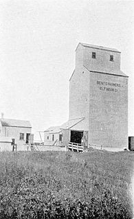
Benito is an unincorporated urban community in the Municipality of Swan Valley West, Manitoba, Canada.
St. Clements is a rural municipality in Manitoba, Canada. It is located to the north-east of Winnipeg, stretching from East St. Paul and Birds Hill Provincial Park in the south to Lake Winnipeg and Grand Beach Provincial Park to the north. The Red River demarcates the western boundary of the municipality. St. Clements contains the communities of East Selkirk, and Lockport east of the Red River. It almost completely surrounds the Brokenhead 4 Indian reserve, with the exception of a small lakefront on Lake Winnipeg.
Niton Junction is a hamlet in west-central Alberta, Canada within Yellowhead County. It is located on the Yellowhead Highway approximately 45 kilometres (28 mi) east of Edson and 150 kilometres (93 mi) west of Edmonton. It is east of the Yellowhead Highway's junction with Highway 32 and west of Chip Lake. Niton Junction has an elevation of 845 metres (2,772 ft).
Powerview-Pine Falls is a town in the Canadian province of Manitoba, with a population of 1,314 at the 2011 census, up 1.54% from 1,294 at the 2006 census and down 7.57% from 1,400 during the 2001 census.

Somerset is an unincorporated community recognized as a local urban district in the Municipality of Lorne within the Canadian province of Manitoba that held village status prior to January 1, 2015.
Peers is a hamlet in west-central Alberta, Canada within Yellowhead County. It is located on Highway 32, 8 kilometres (5.0 mi) north of the Yellowhead Highway and approximately 35 kilometres (22 mi) northeast of Edson. January Creek, a tributary of the McLeod River flows directly adjacent to the hamlet. Peers is also home to the annual Peers Gold Dust Daze, which takes place ~3 miles away from Peers
Marlboro is a hamlet in west-central Alberta, Canada within Yellowhead County. It is located on the Yellowhead Highway, approximately 25 kilometres (16 mi) west of Edson. Sundance Provincial Park is located northwest of the hamlet.
Anzac is a hamlet in northern Alberta, Canada within the Regional Municipality (RM) of Wood Buffalo. It is located on Highway 881 along the east shore of Gregoire Lake, approximately 36 kilometres (22 mi) southeast of Fort McMurray.
Grand Beach is a designated place in the Canadian province of Newfoundland and Labrador. It is on the Burin Peninsula of the island of Newfoundland.
North Cooking Lake is a hamlet in Alberta, Canada within Strathcona County. It is located on Highway 630 and on the northeast shore of Cooking Lake, approximately 24 kilometres (15 mi) southeast of Sherwood Park. It is 4 kilometres (2.5 mi) south of the Waskehegan Staging Area entrance to Cooking Lake-Blackfoot Grazing, Wildlife Provincial Recreation Area.

Half Moon Lake is a hamlet in Alberta, Canada within Strathcona County. It is also recognized as a designated place by Statistics Canada under the name of Half Moon Estates. The community is located on the shores of Half Moon Lake, just north of Highway 629, approximately 13 kilometers (8.1 mi) southeast of Sherwood Park.

Bellis is a hamlet in central Alberta, Canada within Smoky Lake County. Previously an incorporated municipality, Bellis dissolved from village status on January 1, 1946 to become part of the Municipal District of Vilna No. 575.
Chin is a hamlet in southern Alberta, Canada within the Lethbridge County. It is located 1 kilometre (0.62 mi) north of Highway 3, approximately 27 kilometres (17 mi) east of Lethbridge.
Donatville is a hamlet in northern Alberta, Canada within Athabasca County. It is on Highway 63, approximately 118 kilometres (73 mi) northeast of Fort Saskatchewan. The community has the name of Donat Gingras, a pioneer citizen. The first school opened in 1915.
Long Lake is a hamlet in central Alberta, Canada within Thorhild County. It is located on the west shore of Long Lake, approximately 12 kilometres (7.5 mi) east of Highway 63 and 114 kilometres (71 mi) northeast of Edmonton.
Tillicum Beach is a hamlet in central Alberta, Canada within Camrose County. It is 3 kilometres (1.9 mi) west Highway 56, approximately 16 kilometres (9.9 mi) southeast of Camrose. It is located along Dried Meat Lake.
Dallas/Red Rose is a designated northern community in the Canadian province of Manitoba, consisting of the adjacent communities of Dallas and Red Rose. The communities had a total population of 159 as of the 2016 census, up from 45 in the 2006 census.
Miniota, Manitoba is an unincorporated community recognized as a local urban district in Prairie View Municipality, Manitoba, Canada. It is located northwest of Virden near the intersection of PTH 83 and PTH 24. The post office opened in 1885 on 36-13-27W. It was originally named Parkisimo and changed to its present name in 1900. It had two railways in its history: the Canadian Pacific Railway and the Grand Trunk Railway. Both had rail points about one mile apart and there was a Miniota Station on the latter.
Laurier is an unincorporated urban community in the Rural Municipality of Ste. Rose, Manitoba, Canada. It is located on Highway 480, 3.2 km (2.0 mi) west of Highway 5, between the community of McCreary to the south and the community of Ste. Rose du Lac to the north.

