
Hamiota is an unincorporated urban community in the Hamiota Municipality within the Canadian province of Manitoba that held town status prior to January 1, 2015. It is located on Provincial Trunk Highway 21 midway between the Trans-Canada Highway and the Yellowhead Highway. It is located in Western Manitoba, 84 kilometers northwest of Brandon. The trading area radius of 20 kilometres has approximately 10,000 people. First known as Hamilton, for Thomas Hamilton, one of the first settlers, the town name was changed to avoid confusion with Hamilton, Ontario. The new name contracted Hamilton with the Sioux word ota, "much".
Roseau River Anishinabe First Nation is an Ojibway First Nation in southern Manitoba, Canada, situated around the Roseau River.

The County of Stettler No. 6 is a municipal district in central Alberta, Canada.
St. Andrews is a rural municipality (RM) in Manitoba, Canada. It lies west of the Red River; its southern border is approximately 8 kilometres (5.0 mi) north of Winnipeg.
Erickson is an unincorporated urban community in the Municipality of Clanwilliam – Erickson within the Canadian province of Manitoba that held town status prior to 1 January 2015. It is located on Highway 10 on 32-17-18W in south central Manitoba. The main industry of Erickson is agriculture.

St. Clements is a rural municipality (RM) in Manitoba, Canada. It is located to the north-east of Winnipeg, stretching from East St. Paul and Birds Hill Provincial Park in the south to Lake Winnipeg and Grand Beach Provincial Park to the north. The Red River demarcates the western boundary of the municipality. St. Clements contains the communities of East Selkirk, and Lockport east of the Red River. It almost completely surrounds the Brokenhead 4 Indian reserve, with the exception of a small lakefront on Lake Winnipeg.
Powerview-Pine Falls is a town in the Canadian province of Manitoba, with a population of 1,314 at the 2011 census, up 1.54% from 1,294 at the 2006 census and down 7.57% from 1,400 during the 2001 census.
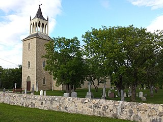
St. Georges is a small community in Manitoba, on the Winnipeg River. It is located in the Rural Municipality of Alexander and home to the municipality's administrative offices. The parish began in 1882 when Father Joachim Allard left from the Fort Alexander Indian reserve to live on the Winnipeg River. He invited residents of Chateauguay Quebec to join him so that they could create a French-Canadian parish in the middle of Manitoba. The first chapel was constructed in 1903 and from then on the area became known as Saint-Georges de Chateauguay parish. The first church built in what is now known as St. Georges was in 1909. In 2003 a monument was built to commemorate the hundredth anniversary of the founding of the parish.

Peguis First Nation is the largest First Nations community in Manitoba, Canada, with a population of approximately 11,438 people. The members of Peguis are of Saulteaux (Ojibway) and Maškēkowak descent.

St. Ambroise Beach is a 46-hectare (110-acre) provincial park on the shore of Lake Manitoba in the Rural Municipality of Portage la Prairie of Canada. Established in 1961, the park lies in the Lake Manitoba Plain Ecoregion and is surrounded by marshland, which provides a habitat for waterfowl. The park is open to the public for recreational activities and birding. Piping plovers nest on the beach and warblers, geese and pelicans pass through the park during migration season. A boardwalk with a viewing tower extends into the marsh. St. Ambroise Beach is a stop on the international Pine to Prairie birding trail, which runs from Minnesota through Manitoba.
The Rural Municipality of Clanwilliam is a former rural municipality (RM) in the Canadian province of Manitoba. It was originally incorporated as a rural municipality on December 22, 1883. It ceased on January 1, 2015 as a result of its provincially mandated amalgamation with the Town of Erickson to form the Municipality of Clanwilliam – Erickson.

Census Division No. 13 is a census division located within the Interlake Region of the province of Manitoba, Canada. Unlike in some other provinces, census divisions do not reflect the organization of local government in Manitoba. These areas exist solely for the purposes of statistical analysis and presentation; they have no government of their own.

Ste. Anne is a rural municipality (RM) in the Eastman Region of Manitoba, Canada, lying southeast of Winnipeg. The separately-administered town of Ste. Anne lies within the geographic borders of the municipality, in its northwestern part.
Brokenhead Ojibway Nation is an Anishinaabe (Saulteaux/Ojibwa) First Nation located approximately 64 kilometres (40 mi) northeast of Winnipeg, Manitoba.

St. Paul is a provincial electoral division in the Canadian province of Manitoba. It was created by electoral redistribution in 2008 mostly out of the old Springfield riding.
Petersfield is located in the Rural Municipality of St. Andrews in Manitoba, Canada. It was the birthplace of First Nation war hero and community activist Tommy Prince. In Summer, Petersfield plays host to the Petersfield Community Club Mallard Park Market, a popular local destination for locally handmade crafts, baking, vegetables, etc.
Libau Bog Ecological Reserve is an ecological reserve located in the Mars Hill Wildlife Management Area, Manitoba, Canada. It was established in 1989 under the Manitoba Ecological Reserves Act. It is 1.8 square kilometres (0.69 sq mi) in size.

Patricia Beach Provincial Park is a provincial park on the south-east shore of Balsam Bay on Lake Winnipeg in Manitoba, Canada. The park is located within the Rural Municipality of St. Clements and can be accessed by road from Manitoba Provincial Road 319. In the summer, people relax by the lake on the fine sand beach. During the winter, people using snowmobiles or quads to go ice fishing on Balsam Bay get on to the lake from the south parking lot.
