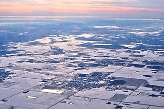
The Rural Municipality of Hanover is a rural municipality (RM) in southeastern Manitoba, Canada, located southeast of Winnipeg in Division No. 2.
Ashern is a local urban district located in the Municipality of West Interlake in Manitoba's Interlake Region.
St. Claude is an unincorporated community recognized as a local urban district in the Rural Municipality of Grey within the Canadian province of Manitoba that held village status prior to January 1, 2015.

Baldur is an unincorporated community recognized as a local urban district in the Canadian province of Manitoba, located in the Rural Municipality of Argyle. Baldur is the largest community of the municipality, which is in southwestern Manitoba between Brandon and Portage la Prairie. The community is named after the Norse god Baldur.
Fisher Branch is an unincorporated community recognized as a local urban district in the Rural Municipality of Fisher in the Canadian province of Manitoba. It is located on Highway 17 in the north Interlake Region of the province. Fisher Branch was originally named Wasoo, but later was changed to Fisher Branch because it was beside a branch of the Fisher River. The primary industry of Fisher Branch is agriculture.
Notre Dame de Lourdes is an unincorporated community recognized as a local urban district in the Municipality of Lorne within the Canadian province of Manitoba that held village status prior to January 1, 2015. It is located within the Central Plains Region, 100 km southwest of Winnipeg. The community had a population of 683 inhabitants in the 2011 census, an increase of 16.0% from the 589 inhabitants during the 2006 census.
Reston is an unincorporated community recognized as a local urban district in southwestern Manitoba, located near the border of Saskatchewan on the west and North Dakota on the south. It is the largest community in the Rural Municipality of Pipestone, which also includes Sinclair, Cromer and Pipestone.

Somerset is an unincorporated community recognized as a local urban district in the Municipality of Lorne within the Canadian province of Manitoba that held village status prior to January 1, 2015.

Manitoba is one of Canada's 10 provinces. It is the easternmost of the three Prairie provinces.

The Rural Municipality of Coldwell is a rural municipality in the Interlake Region of the province of Manitoba in Western Canada. The principal community within the boundaries is Lundar.

The Rural Municipality of Mountain is a rural municipality (RM) in the Parkland Region of Manitoba, western Canada.
Altamont is an unincorporated community recognized as a local urban district located within the Municipality of Lorne in south central Manitoba, Canada.

The Rural Municipality of Brokenhead is a rural municipality (RM) in the Canadian province of Manitoba.


