Manitoba Highway 11

Last updated

Manitoba Highway 11.svg

Provincial Trunk Highway 11

Route information
Maintained by Manitoba Infrastructure
Length140 km (87 mi)
Existed1926–present
Major junctions
South endManitoba Highway 1.svg PTH 1 (TCH) south of Hadashville
Major intersections
North endManitoba Highway 59.svg PTH 59 south of Victoria Beach
Location
Country Canada
Province Manitoba
Rural municipalities
Towns
Highway system
Manitoba Highway 10A.svg PTH 10A Manitoba Highway 12.svg PTH 12

Provincial Trunk Highway 11 (PTH 11) is a provincial primary highway located in the Eastman Region of the Canadian province of Manitoba. It runs from an intersection with PTH 59 near Victoria Beach to an intersection with PTH 1.

Contents

Route description

PTH 11 begins at an intersection with PTH 1 (Trans-Canada Highway) in the hamlet of Hadashville, located in the Rural Municipality of Reynolds. The highway heads north through the hamlet, running parallel to the western banks of the Whitemouth River, eventually leaving and traveling just to the west of Medika and Reynolds, having intersections with PR 507 and PR 506, before crossing into the Rural Municipality of Whitemouth.

PTH 11 travels straight through the town of Elma, where it has a junction with PTH 15 and makes its first crossing of the Whitemouth River, before becoming concurrent with PTH 44 and making its second crossing of the river as the two head west. The highway curves northwestward to follow along the western banks of the river, having an intersection with PR 406 as they travel through the town of Whitemouth. PTH 11 / PTH 44 have an intersection with PR 408 as they wind up the riverbanks for several kilometers before PTH 11 splits off and heads north at a junction in Siegs Corner. PTH 11 has an intersection with PR 307 near Seven Sisters Falls, where the highway joins the La Vérendrye Trail, as well as passes by the Whiteshell Provincial Park (the site of where the Whitemouth River merged into the Winnipeg River).

PTH 11 follows the Winnipeg river northward to cross into the Rural Municipality of Lac du Bonnet immediately before having an intersection with PR 211 (leads to Pinawa and Pinawa Provincial Wayside Park) and traveling through Brookfield. The highway passes briefly through the Pinawa Local Government District before re-entering the Rural Municipality of Lac du Bonnet and having an intersection with PR 214. It now travels through the town of Lac du Bonnet, mostly following a western bypass of the town as it has intersections with PR 502 and PR 317. The highway travels along the coastline of Lac du Bonnet and has an intersection with PR 313 before crossing into the Rural Municipality of Alexander.

PTH 11 passes by several reservoirs along the Winnipeg River for the next several kilometers, traveling through Crescent Bay and past McArthur Falls Generating Station. The highway curves to the west, as it travels through the hamlet of Great Falls and passes by the Great Falls Generating Station, before winding its way northwest along the riverbanks, passing through White Mud Falls, Silver Falls, and St. Georges. It enters the town of Powerview-Pine Falls at an intersection with PR 304, passing directly through both sectors of town before leaving Powerview-Pine Falls and traveling through the Sagkeeng First Nation for the next several kilometers.

PTH 11 re-enters the Rural Municipality of Alexander as it starts following the southeastern coastline of Lake Winnipeg, which follows westward for a few kilometers before coming to an end at an intersection with PTH 59, just south of the border with the Rural Municipality of Victoria Beach. La Vérendrye Trail follows PTH 59 southbound.

With the exclusion of an extremely short section of 4-land divided highway at the junction between PTH 44 and PTH 11 in Siegs Corner, the entire length Provincial Trunk Highway 11 is a paved, rural, two lane highway. [1] [2]

History

PTH 11 is one of the original numbered highways within the province of Manitoba, first appearing on the original 1926 Manitoba Highway Map. [3] Originally a short connector highway spanning 32 kilometres (20 mi) between PTH 1 at Seddons Corner and Lac du Bonnet, the highway was extended north to Pine Falls in 1947. [4]

In 1954, PTH 11 obtained the distinction of being both a north-south and east-west highway much like current Provincial Trunk Highways 5, 20, and 50. That year, the highway was extended south through Whitemouth (running in concurrence with PTH 1), Elma and Hadashville before turning west to meet PTH 12 just north of Ste. Anne. [5] The following year, the section between PR 214 and PTH 44 was completed and opened to traffic. [6] The former east-west section of PTH 11 was redesignated as PTH 1 in 1958 in preparation for its inclusion in the Trans-Canada Highway system four years later. This redesignated PTH 11 to its current southbound terminus near Hadashville. [7]

PTH 11 was extended farther north from Pine Falls to its current northbound terminus with PTH 59 in 1966, replacing what had been previously designated as PTH 12. [8]

Major intersections

DivisionLocationkmmiDestinationsNotes
Reynolds 00.0Manitoba Highway 1.svg PTH 1 (TCH)  Winnipeg, Falcon Lake
95.6Manitoba secondary 507.svg PR 507 east Medika
↑ / ↓169.9Manitoba secondary 506.svg PR 506 south / Spruce Siding Road (Road 54 North)
Whitemouth Elma 2415Manitoba Highway 15.svg PTH 15 west Anola, Winnipeg
3220Manitoba Highway 44.svg PTH 44 east West Hawk Lake south end of PTH 44 overlap
3622Manitoba secondary 406.svg PR 406 south Elma
4427Manitoba secondary 408.svg PR 408 north River Hills
Siegs Corner 5434Manitoba Highway 44.svg PTH 44 west Beausejour, Winnipeg north end of PTH 44 overlap
5937Manitoba secondary 307.svg PR 307 east Seven Sisters Falls, Whiteshell Provincial Park La Vérendrye Trail branches east onto PR 307
Lac du Bonnet Brookfield 6339Manitoba secondary 211.svg PR 211 east Pinawa
Pinawa L.G.D.
No major junctions
Lac du Bonnet 7345Manitoba secondary 214.svg PR 214 south (Milner Ridge Road)
Town of Lac du Bonnet 7848Manitoba secondary 502.svg PR 502 north
7949Manitoba secondary 317.svg PR 317  Libau
Lac du Bonnet 8251Manitoba secondary 313.svg PR 313 east Pointe du Bois
Town of Powerview-Pine Falls 11471Manitoba secondary 304.svg PR 304  Stead, Beaconia, Bissett
Sagkeeng First Nation
No major junctions
Alexander 14087Manitoba Highway 59.svg PTH 59  Winnipeg, Victoria Beach La Vérendrye Trail continues east on PTH 59 south
1.000 mi = 1.609 km; 1.000 km = 0.621 mi

Related Research Articles

<span class="mw-page-title-main">Winnipeg River</span> River in the Canadian provinces of Manitoba and Ontario

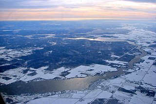
The Winnipeg River is a Canadian river that flows roughly northwest from Lake of the Woods in the province of Ontario to Lake Winnipeg in Manitoba. This river is 235 kilometres (146 mi) long from the Norman Dam in Kenora to its mouth at Lake Winnipeg. Its watershed is 106,500 square kilometres (41,100 sq mi) in area, mainly in Canada. About 29,000 square kilometres (11,000 sq mi) of the watershed is in northern Minnesota, United States.

Provincial Trunk Highway 4 is a provincial highway in the Canadian province of Manitoba. The highway connects the city of Selkirk to PTH 59, the main route to Grand Beach and cottage country on the east side of Lake Winnipeg.

Provincial Trunk Highway 6 is a provincial primary highway located in the Canadian province of Manitoba. It runs from the Perimeter Highway of Winnipeg to the Thompson south city limits. It is also the main highway connecting Winnipeg to northern Manitoba. The speed limit is 100 km/h. The route is also used to deliver nickel from the Thompson mine to the Royal Canadian Mint in Winnipeg. The portion of the highway between Ponton and Thompson was known as Highway 391 prior to 1986.

Provincial Trunk Highway 9 is a provincial primary highway located in the Canadian province of Manitoba. It runs from Winnipeg north to Gimli.

Provincial Trunk Highway 8 is a provincial primary highway located in the Canadian province of Manitoba. It runs from the north limit of the City of Winnipeg, where it meets with Route 180, north to Hecla-Grindstone Provincial Park. The highway between Winnipeg and PR 230 is known as McPhillips Street. At PR 230, McPhillips Street becomes McPhillips Road and continues along PR 230 to PTH 9. The route is a major road connecting Winnipeg with the communities of Winnipeg Beach and Gimli. The speed limit is 100 km/h (60 mph).

Provincial Trunk Highway 7 is a provincial primary highway located in the Canadian province of Manitoba. It runs from the northern limit of the city of Winnipeg north to Arborg, Manitoba where it intersects with PTH 68. The highway is twinned from Winnipeg to just north of PTH 67, an east-west route that provides access to the Town of Stonewall.

<span class="mw-page-title-main">Manitoba Highway 2</span> Highway in Manitoba

Provincial Trunk Highway 2 is a 315-kilometre (196-mile) highway in the Canadian province of Manitoba. It runs from Highway 13 at the Manitoba-Saskatchewan border to Winnipeg's Perimeter Highway near Oak Bluff.

Provincial Trunk Highway 9A is a provincial primary highway located in the Canadian province of Manitoba. The route is an alternate route of PTH 9 through Selkirk, Manitoba for those that are travelling to and from or want to go through Selkirk itself, instead of taking the bypass. The length of this highway is 7.4 kilometres (4.6 mi).

Provincial Trunk Highway 3A is a provincial primary highway located in the Canadian province of Manitoba. It runs from PTH 3 to the same route concurrent with PTH 34. The highway continues as PR 423 from its eastern terminus.

Provincial Trunk Highway 3 is a major provincial highway located in the Canadian province of Manitoba. It runs from the Saskatchewan boundary to the southwest city limits of Winnipeg, where it continues as Winnipeg Route 155. Prior before to the implementation of Winnipeg's City Route System, it extended to Pembina Highway.

<span class="mw-page-title-main">Eastman Region</span>

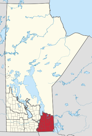
Eastern Manitoba, or the Eastman Region, is an informal geographic region of the Canadian province of Manitoba. It is bounded on the north by the Winnipeg River and Lake Winnipeg, on the east by the Manitoba-Ontario border, on the south by the Canada–US border, and on the west by the Red River.

Provincial Trunk Highway 5 is a provincial primary highway located in the Canadian province of Manitoba.

<span class="mw-page-title-main">Northern Woods and Water Route</span> Highway in Canada

The Northern Woods and Water Route is a 2,400-kilometre (1,500 mi) route through northern British Columbia, Alberta, Saskatchewan and Manitoba in Western Canada. As early as the 1950s, community groups came together to establish a northern travel route; this was proposed as the Northern Yellowhead Transportation Route. The Northern Woods and Water Route Association was established in 1974, and encouraged promotion of the route with the promise of an increase in tourist travel. The route was designated in 1974 and is well signed throughout its component highways. The route starts at Dawson Creek as the Spirit River Highway and ends at the Perimeter of Winnipeg, Manitoba, after running through the northern regions of the western provinces. From west to east, the Northern Woods and Water Route (NWWR) incorporates portions of British Columbia Highway 49; Alberta Highways 49, 2A, 2, & 55; Saskatchewan Highways 55 & 9; Manitoba Provincial Road 283 and Trunk Highways 10, 5, 68 & 6. The halfway point of the NWWR is approximately at Goodsoil, Saskatchewan.

Provincial Trunk Highway 10 is a provincial primary highway located in the Canadian province of Manitoba.

Provincial Trunk Highway 44 is a provincial highway in the Canadian province of Manitoba.

<span class="mw-page-title-main">Division No. 1, Manitoba</span> Census division in Manitoba, Canada

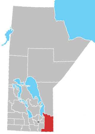
Division No. 1 is a census division located within the Eastman Region of the Canadian province of Manitoba. Unlike in some other provinces, census divisions do not reflect the organization of local government in Manitoba. These areas exist solely for the purposes of statistical analysis and presentation; they have no government of their own.

Provincial Road 373 is a highly recognized all-weather provincial road in Division 22 of Manitoba. The road was made famous by a group of singers from Norway House, who named their band Highway 373. PR 373 begins at an intersection with Highway 6 in Setting Lake, heads eastward through rural regions, and terminating at an intersection with local roads in Norway House. There is one major intersection along the way, Road 374, which heads north to Cross Lake. PR 373's entire length is declared a class A1 provincial road.

Provincial Trunk Highway 13 is a provincial highway in the Canadian province of Manitoba. It is an RTAC route capable of handling RTAC vehicles such as trucks, truck and pony trailers, trucks and full trailers, truck tractors and semi-trailers, A-trains, B-trains, or C-trains. The route extends south to north from its junction with PTH 3 and PR 245 in Carman to its junction with PTH 1 and PR 430 north of Oakville. The northern terminus of PTH 13 is located between Portage la Prairie and Manitoba's capital city Winnipeg. The Central Manitoba Railway (CEMR) shortline rail intersects PTH 13 north of Carman, the Canadian Pacific Railway (CPR) intersects at Elm Creek, and the Canadian National Railway (CNR) at Oakville.

Provincial Highway 14 is a provincial highway in Manitoba. PTH 14 is a 2 lane high-speed rural highway (100 km/h) and carries relatively high traffic volumes of approximately 1800 vehicles per day. The route extends west to east from its junction with PTH 3 to its junction with PTH 75, the Lord Selkirk Highway.

The La Vérendrye Trail is a series of highways in the Canadian province of Manitoba commemorating the oldest waterway fur-trading route in the province. It is named after Pierre Gaultier de Varennes, sieur de La Vérendrye, an explorer and fur-trader who is often credited as being the first European to visit what is now southern Manitoba.

References

Route map:

Template:Attached KML/Manitoba Highway 11
KML is from Wikidata
  1. Government of Manitoba. "Official Highway map of Manitoba #3" (PDF). Retrieved January 2, 2023.
  2. Google (January 2, 2023). "Map of Manitoba Provincial Trunk Highway 11" (Map). Google Maps . Google. Retrieved January 2, 2023.
  3. Manitoba Highway Map (PDF) (Map). Manitoba Minister of Infrastructure and Transportation. 1926. Retrieved June 22, 2015.[ permanent dead link ]
  4. Manitoba Highway Map (PDF) (Map). Manitoba Minister of Infrastructure and Transportation. 1947–1948. Retrieved June 22, 2015.
  5. Manitoba Highway Map (PDF) (Map). Manitoba Minister of Infrastructure and Transportation. 1954. Retrieved June 22, 2015.
  6. Manitoba Highway Map (PDF) (Map). Manitoba Minister of Infrastructure and Transportation. 1955. Retrieved June 22, 2015.
  7. Manitoba Highway Map (PDF) (Map). Manitoba Minister of Infrastructure and Transportation. 1958. Retrieved June 22, 2015.
  8. Manitoba Highway Map (PDF) (Map). Manitoba Minister of Infrastructure and Transportation. 1966–1967. Retrieved June 22, 2015.