Provincial Trunk Highway 1 is Manitoba's section of the Trans-Canada Highway. It is a heavily used, 4-lane divided highway, with the exception of a short 18 km section in the southeastern corner of the province. It is the main link between southern Manitoba's largest cities, and also serves as the province's main transportation link to the neighbouring provinces of Saskatchewan and Ontario. The highway is the only major east-west divided highway in Manitoba, and carries a large majority of east-west traffic within and through the province. It has full freeway status sections at Portage la Prairie and Winnipeg. The total distance of the Trans-Canada Highway in Manitoba is approximately 490 km (300 mi).
Provincial Trunk Highway 59 is a major provincial highway in the Canadian province of Manitoba. It runs from the Lancaster-Tolstoi Border Crossing, through the city of Winnipeg, north to 8th Avenue in Victoria Beach on Lake Winnipeg.
Provincial Trunk Highway 6 is a provincial primary highway located in the Canadian province of Manitoba. It runs from the Perimeter Highway of Winnipeg to the Thompson south city limits. It is also the main highway connecting Winnipeg to northern Manitoba. The speed limit is 100 km/h. The route is also used to deliver nickel from the Thompson mine to the Royal Canadian Mint in Winnipeg. The section of highway between its southern terminus near Winnipeg and the second junction with PTH 68 near Eriksdale is part of the Northern Woods and Water Route. The portion of the highway between Ponton and Thompson was known as Highway 391 prior to 1986.
Provincial Trunk Highway 9 is a provincial primary highway located in the Canadian province of Manitoba. It runs from Winnipeg north to Gimli.
Provincial Trunk Highway 8 is a provincial primary highway located in the Canadian province of Manitoba. It runs from the north limit of the City of Winnipeg, where it meets with Route 180, north to Hecla-Grindstone Provincial Park. The highway between Winnipeg and PR 230 is known as McPhillips Street. At PR 230, McPhillips Street becomes McPhillips Road and continues along PR 230 to PTH 9. The route is a major road connecting Winnipeg with the communities of Winnipeg Beach and Gimli. The speed limit is 100 km/h (60 mph).
Provincial Trunk Highway 7 is a provincial primary highway located in the Canadian province of Manitoba. It runs from the northern limit of the city of Winnipeg north to Arborg, Manitoba where it intersects with PTH 68. The highway is twinned from Winnipeg to just north of PTH 67, an east-west route that provides access to the Town of Stonewall.

Provincial Trunk Highway 2 is a 315-kilometre (196-mile) highway in the Canadian province of Manitoba. It runs from Highway 13 at the Manitoba-Saskatchewan border to Winnipeg's Perimeter Highway near Oak Bluff.
Provincial Trunk Highway 15 is a provincial highway in the Canadian province of Manitoba. It runs from Winnipeg's Perimeter Highway east to Elma where it ends at PTH 11. PTH 15 and the portion of Route 115 east of PTH 59 are collectively known as Dugald Road.
Provincial Trunk Highway 11 (PTH 11) is a provincial primary highway located in the Eastman Region of the Canadian province of Manitoba. It runs from an intersection with PTH 59 near Victoria Beach to an intersection with PTH 1.
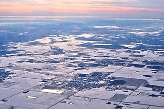
Beausejour is a town in the Canadian province of Manitoba. It is 46 kilometres northeast of Winnipeg, just west of the Canadian Shield and Whiteshell Provincial Park. The French name Beauséjour [beau + séjour] means "beautiful stay". The town is surrounded by the Rural Municipality of Brokenhead.
Provincial Trunk Highway 5 is a provincial primary highway located in the Canadian province of Manitoba.

Provincial Trunk Highway 10 is a provincial primary highway located in the Canadian province of Manitoba.

Provincial Trunk Highway 12 is a provincial primary highway located in the Canadian province of Manitoba. Lying entirely in the Eastman Region, it runs from the U.S. border to a dead end in Grand Beach. PTH 12 forms the Manitoba section of MOM's Way, a tourist route from Thunder Bay to Winnipeg. PTH 12 is primarily a two-lane highway except for two four-lane stretch between Steinbach and PTH 1 and a ten-kilometre concurrency with PTH 44.
Provincial Trunk Highway 44 is an east-west provincial highway in the Eastman Region of the Canadian province of Manitoba.

Provincial Road 304 is a provincial road in the Eastman and NorMan regions of Manitoba, Canada. It begins at PTH 59/PTH 12 south of Grand Beach and runs to Powerview-Pine Falls at the PTH 11 junction. Near the town, PR 304 crosses the Winnipeg River at the Pine Falls Generating Station, operated by Manitoba Hydro. From there, PR 304 heads north and then east to the community of Bissett, before terminating at Provincial Road 314 near the northern boundary of Nopiming Provincial Park.

Provincial Road 314 is a provincial road in the Eastman Region of Manitoba, Canada, running through Nopiming Provincial Park. It begins at PR 304 near the northern boundary of the park and becomes PR 315 near its southern boundary.
Provincial Road 315 is a provincial road in the Eastman Region of Manitoba, Canada. It begins at PR 313 northeast of Lac du Bonnet and ends at the Ontario boundary, running through the southern part of Nopiming Provincial Park.
Provincial Road 214, also called Milner Ridge Road, is a short provincial road in the province of Manitoba, Canada. It runs through the Agassiz Provincial Forest from PTH 44 at Seddons Corner to PTH 11.

Provincial Road 307 is a provincial road in the Eastman Region of the Canadian province of Manitoba. It is part of the La Vérendrye Trail in eastern Manitoba and lies mostly within Whiteshell Provincial Park.
The La Vérendrye Trail is a series of highways in the Canadian province of Manitoba commemorating the oldest waterway fur-trading route in the province. It is named after Pierre Gaultier de Varennes, sieur de La Vérendrye, an explorer and fur-trader who is often credited as being the first European to visit what is now southern Manitoba.
