Provincial Trunk Highway 1 is Manitoba's section of the Trans-Canada Highway. It is a heavily used, 4-lane divided highway, with the exception of a short 18 km section in the southeastern corner of the province. It is the main link between southern Manitoba's largest cities, and also serves as the province's main transportation link to the neighbouring provinces of Saskatchewan and Ontario. The highway is the only major east-west divided highway in Manitoba, and carries a large majority of east-west traffic within and through the province. It has full freeway status sections at Portage la Prairie and Winnipeg. The total distance of the Trans-Canada Highway in Manitoba is approximately 490 km (300 mi).
Provincial Trunk Highway 59 is a major provincial highway in the Canadian province of Manitoba. It runs from the Lancaster-Tolstoi Border Crossing, through the city of Winnipeg, north to 8th Avenue in Victoria Beach on Lake Winnipeg.
Provincial Trunk Highway 6 is a provincial primary highway located in the Canadian province of Manitoba. It runs from the Perimeter Highway of Winnipeg to the Thompson south city limits. It is also the main highway connecting Winnipeg to northern Manitoba. The speed limit is 100 km/h. The route is also used to deliver nickel from the Thompson mine to the Royal Canadian Mint in Winnipeg. The section of highway between its southern terminus near Winnipeg and the second junction with PTH 68 near Eriksdale is part of the Northern Woods and Water Route. The portion of the highway between Ponton and Thompson was known as Highway 391 prior to 1986.
Provincial Trunk Highway 9 is a provincial primary highway located in the Canadian province of Manitoba. It runs from Winnipeg north to Gimli.
Provincial Trunk Highway 8 is a provincial primary highway located in the Canadian province of Manitoba. It runs from the north limit of the City of Winnipeg, where it meets with Route 180, north to Hecla-Grindstone Provincial Park. The highway between Winnipeg and PR 230 is known as McPhillips Street. At PR 230, McPhillips Street becomes McPhillips Road and continues along PR 230 to PTH 9. The route is a major road connecting Winnipeg with the communities of Winnipeg Beach and Gimli. The speed limit is 100 km/h (60 mph).

Provincial Trunk Highway 2 is a 315-kilometre (196-mile) highway in the Canadian province of Manitoba. It runs from Highway 13 at the Manitoba-Saskatchewan border to Winnipeg's Perimeter Highway near Oak Bluff.
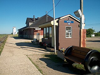
Rivers is an unincorporated urban community in the Riverdale Municipality within the Canadian province of Manitoba. It is located 40 kilometres (25 mi) northwest of Brandon, 473 metres (1,552 ft) above sea level. It is within the Westman Region. Agriculture, health and related businesses provide income for the community and area. Rivers has a population of 1,257 people in the 2016 census.

Provincial Trunk Highway 3 (PTH 3) is a major provincial highway located in the Canadian province of Manitoba. It runs from the Saskatchewan boundary to the southwest city limits of Winnipeg, where it continues as Winnipeg Route 155. Prior before to the implementation of Winnipeg's City Route System, it extended to Pembina Highway.
Provincial Trunk Highway 11 is a provincial primary highway located in the Eastman Region of the Canadian province of Manitoba. It runs from an intersection with PTH 59 near Victoria Beach to an intersection with PTH 1.

Whiteshell Provincial Park is a provincial park in southeast Manitoba, approximately 120 kilometres (75 mi) east of the city of Winnipeg. The park is considered to be a Class II protected area under the IUCN protected area management categories. It is 275,210 hectares in size.

Provincial Trunk Highway 12 is a provincial primary highway located in the Canadian province of Manitoba. Lying entirely in the Eastman Region, it runs from the U.S. border to a dead end in Grand Beach. PTH 12 forms the Manitoba section of MOM's Way, a tourist route from Thunder Bay to Winnipeg. PTH 12 is primarily a two-lane highway except for two four-lane stretch between Steinbach and PTH 1 and a ten-kilometre concurrency with PTH 44.

Provincial Road 204 is a provincial road in the Canadian province of Manitoba. PR 204 stretches from the province's capital, Winnipeg, to Selkirk, running under the name Henderson Highway between Winnipeg and PR 202. It has a short concurrency with PTH 44 in Lockport. PR 204 is part of the La Vérendrye Trail between Winnipeg and PR 212 in East Selkirk.
Provincial Trunk Highway 44 is an east-west provincial highway in the Eastman Region of the Canadian province of Manitoba.

Provincial Road 222 is a provincial road in the Interlake Region of the Canadian province of Manitoba. Essentially a northerly continuation of Highway 9, the road extends for 42.6 kilometres (26.5 mi) along the western shore of Lake Winnipeg between the communities of Gimli and Riverton.

Provincial Road 206 is a 61.7-kilometre-long (38.3 mi) north-south provincial road in the Eastman Region of Manitoba, Canada, connecting the communities of Randolph, Landmark, Dugald, Oakbank and Lockport. It also passes by Birds Hill Provincial Park.
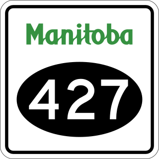
Provincial Road 427 is a short provincial road in the Rural Municipality of Headingley, Manitoba, Canada.

Provincial Road 304 is a provincial road in the Eastman and NorMan regions of Manitoba, Canada. It begins at PTH 59/PTH 12 south of Grand Beach and runs to Powerview-Pine Falls at the PTH 11 junction. Near the town, PR 304 crosses the Winnipeg River at the Pine Falls Generating Station, operated by Manitoba Hydro. From there, PR 304 heads north and then east to the community of Bissett, before terminating at Provincial Road 314 near the northern boundary of Nopiming Provincial Park.

Provincial Road 314 is a provincial road in the Eastman Region of Manitoba, Canada, running through Nopiming Provincial Park. It begins at PR 304 near the northern boundary of the park and becomes PR 315 near its southern boundary.

Provincial Road 313 is a provincial road in the Eastman Region of Manitoba, Canada. It begins at PTH 11 near Lac du Bonnet and ends at the remote community of Pointe du Bois.

Provincial Road 238 (PR 238), also known as River Road, is a provincial road in the Canadian province of Manitoba, in the Rural Municipality of St. Andrews.
