Swan Lake First Nation

Last updated
Swan Lake First Nation
Band No. 293
People Saulteaux
Treaty Treaty 1
Land [1]
Main reserveSwan Lake 7
Other reserve(s)
Indian Reserves 7A, 8, and 8A
Land area65.40 km2
Population (2021) [1]
On reserve408
Off reserve1053
Total population1461
Government [1]
ChiefJason Daniels
Council
Michael Esquash, Francine Meeches, Sean D. McKinney and Craig Soldier
Website
swanlakefirstnation.com

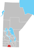
The Swan Lake First Nation (Ojibwe : Gaa-biskigamaag, [2] meaning The lake that is curved) is a Saulteaux band government located along Swan Lake in the Pembina Valley Region of Manitoba, Canada.

Contents

Its main reserve is Swan Lake 7, which is surrounded by the Municipality of Lorne; the First Nation also has economic initiatives located at their reserve nearby the Rural Municipality of Headingley (IR 8A).

Reserve lands

Swan Lake 7
Coordinates: 49°23′09″N98°57′18″W / 49.3858131°N 98.9550057°W / 49.3858131; -98.9550057
Area
  Land27.72 km2 (10.70 sq mi)
Population
 (2016) [3]
  Total347

Swan Lake First Nation divided into 4 reserve lands: [1]

Related Research Articles

<span class="mw-page-title-main">Nisichawayasihk Cree Nation</span>

The Nisichawayasihk Cree Nation is a Cree First Nations community centered in Nelson House, Manitoba, Canada. Its main reserve is Nelson House 170.

<span class="mw-page-title-main">Northern Manitoba</span> Region of Manitoba, Canada

Northern Manitoba is a geographic and cultural region of the Canadian province of Manitoba. Originally encompassing a small square around the Red River Colony, the province was extended north to the 60th parallel in 1912. The region's specific boundaries vary, as "northern" communities are considered to share certain social and geographic characteristics, regardless of latitude.

<span class="mw-page-title-main">Portage—Lisgar</span> Federal electoral district in Manitoba, Canada

Portage—Lisgar is a federal electoral district in Manitoba, Canada, that has been represented in the House of Commons of Canada since 1997.

<span class="mw-page-title-main">Winnipeg Metropolitan Region</span> Metropolitan area in Manitoba, Canada

The Winnipeg Metropolitan Region is a metropolitan area in the Canadian province of Manitoba located in the Red River Valley in the southeast portion of the province of Manitoba, Canada. It contains the provincial capital of Winnipeg and 17 surrounding rural municipalities, cities, and towns.

Roseau River Anishinabe First Nation is an Ojibway First Nation in southern Manitoba, Canada, situated around the Roseau River.

<span class="mw-page-title-main">St. Theresa Point First Nation</span> Indian reserve in Manitoba, Canada

St. Theresa Point First Nation is a First Nations community in northern Manitoba. It has 3 reserves in total, the largest and most populated of which is St. Theresa Point, which is bordered by the unorganized portion of Division No. 22, Manitoba, and by the Wasagamack First Nation.

<span class="mw-page-title-main">Long Plain First Nation</span> Indian reserve in Manitoba, Canada

The Long Plain First Nation is an Ojibway and Dakota First Nations band government in Manitoba, Canada.

<span class="mw-page-title-main">Division No. 19, Manitoba</span> Census division in Manitoba, Canada

Division No. 19, also informally known as North East Manitoba, is a census division within the Province of Manitoba, Canada. Unlike in some other provinces, census divisions do not reflect the organization of local government in Manitoba. These areas exist solely for the purposes of statistical analysis and presentation; they have no government of their own.

Buffalo Point First Nation is an Ojibwa or Saulteaux First Nations located in the southeastern corner of Manitoba, along the shores of Lake of the Woods. It is bordered largely by the unorganized portion of Division No. 1, Manitoba, and also has smaller borders with the Rural Municipality of Piney, as well as the northeast corner of Roseau County, Minnesota.

<span class="mw-page-title-main">Division No. 4, Manitoba</span> Census division in Manitoba, Canada

Division No. 4 is a census division located within the Pembina Valley Region in the south-central region of the province of Manitoba, Canada. Unlike in some other provinces, census divisions do not reflect the organization of local government in Manitoba. These areas exist solely for the purposes of statistical analysis and presentation; they have no government of their own.

<span class="mw-page-title-main">Rural Municipality of Lorne</span>

The Rural Municipality of Lorne is a former rural municipality (RM) in the Canadian province of Manitoba. It was originally incorporated as a rural municipality on February 14, 1880. It ceased on January 1, 2015 as a result of its provincially mandated amalgamation with the Village of Notre Dame de Lourdes and the Village of Somerset to form the Municipality of Lorne.

The Rural Municipality of Louise is a former rural municipality (RM) in the Canadian province of Manitoba. It was originally incorporated as a rural municipality on February 14, 1880. It ceased on January 1, 2015 as a result of its provincially mandated amalgamation with the Town of Pilot Mound and the Village of Crystal City to form the Municipality of Louise.

<span class="mw-page-title-main">Rural Municipality of Kelsey</span> Rural municipality in Manitoba, Canada

Kelsey is a Manitoban rural municipality embedded within the province's Northern Region. It consists of several disjoint parts. The largest part is Carrot Valley, located around and southwest of The Pas along the Carrot River, but the communities of Wanless and Cranberry Portage, located further north, are also part of the municipality. It is 867.64 km2 large. Also lying in the area around The Pas is the Opaskwayak Cree Nation Indian reserve.

Hollow Water First Nation is an Anishinaabe (Ojibwa) First Nation located on the east side of Lake Winnipeg, Canada, 75 km (47 mi) north of Pine Falls, Manitoba, and 217 km (135 mi) north of Winnipeg.

Division No. 1, Unorganized, or Whiteshell Unorganized, is a Statistics Canada census subdivision of its Division No. 1, Manitoba that consists of a part of the division that is not organized into either incorporated municipalities or Indian reserves. Unlike in some other provinces, census divisions do not reflect the organization of local government in Manitoba.

Brokenhead Ojibway Nation is an Anishinaabe (Saulteaux/Ojibwa) First Nation located approximately 64 kilometres (40 mi) northeast of Winnipeg, Manitoba.

Keeseekoowenin Ojibway First Nation is a First Nations community primarily located on Keeseekoowenin 61, situated near Elphinstone, Manitoba, south of Riding Mountain National Park.

The Rolling River First Nation is an Ojibwe First Nations community in Manitoba, located south of Riding Mountain National Park.

Pinaymootang First Nation is a First Nations people whose home location is on Fairford 50 Reserve at Fairford in the Rural Municipality of Grahamdale, Manitoba, Canada. They are situated on Provincial Trunk Highway 6 in the Interlake Region of Manitoba about 220 kilometres from Winnipeg. The Rural Municipality of Grahamdale forms most of the reserve's land boundary, although it also has a short border with the Little Saskatchewan First Nation as well as significant lakeshore on Lake St. Martin, which is considered as being outside the reserve. The main settlement on the reserve is located at 51°35′55″N98°41′32″W.

<span class="mw-page-title-main">Municipality of Lorne</span> Rural municipality in Manitoba, Canada

The Municipality of Lorne is a rural municipality (RM) in the Canadian province of Manitoba.

References

  1. 1 2 3 4 "About Swan Lake First Nation – Swan Lake First Nation".
  2. Andy Thomas Thomas, Florence Paynter. The Significance of Creating First Nation Traditional Names Maps. Manitoba First Nations Education Resource Centre Inc. https://mfnerc.org/wp-content/uploads/2015/05/The-Significance-of-Creating-First-Nation-Traditional-Names-Maps.pdf Archived 2022-10-20 at the Wayback Machine
  3. "Census Profile, 2016 Census, Statistics Canada - Validation Error".
  4. Statistics Canada (2012), 2011 Census. Statistics Canada Catalogue no. 92-142-XWE, Ottawa, Ontario (published October 24, 2012), archived from the original on July 2, 2013, retrieved February 16, 2017{{citation}}: CS1 maint: location missing publisher (link)

49°23′15″N98°53′28″W / 49.38750°N 98.89111°W / 49.38750; -98.89111