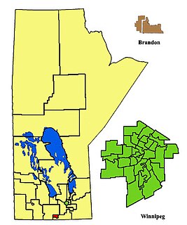
Rathwell is an unincorporated urban centre in the province of Manitoba. It is part of the agricultural area of south central Manitoba, Canada and is situated in the Municipality of Norfolk Treherne.
Rathwell is an unincorporated urban centre in the province of Manitoba. It is part of the agricultural area of south central Manitoba, Canada and is situated in the Municipality of Norfolk Treherne.
| Climate data for Rathwell | |||||||||||||
|---|---|---|---|---|---|---|---|---|---|---|---|---|---|
| Month | Jan | Feb | Mar | Apr | May | Jun | Jul | Aug | Sep | Oct | Nov | Dec | Year |
| Record high °C (°F) | 7.5 (45.5) | 10 (50) | 18.5 (65.3) | 35 (95) | 38.5 (101.3) | 37.5 (99.5) | 36.1 (97.0) | 40 (104) | 38.5 (101.3) | 32 (90) | 23.9 (75.0) | 14.4 (57.9) | 40 (104) |
| Average high °C (°F) | −12 (10) | −7.5 (18.5) | −0.7 (30.7) | 10.3 (50.5) | 19.3 (66.7) | 23.4 (74.1) | 25.6 (78.1) | 25.3 (77.5) | 18.9 (66.0) | 11.2 (52.2) | −0.7 (30.7) | −9 (16) | 8.7 (47.7) |
| Daily mean °C (°F) | −16.9 (1.6) | −12.5 (9.5) | −5.6 (21.9) | 4.2 (39.6) | 12.2 (54.0) | 17 (63) | 19.2 (66.6) | 18.3 (64.9) | 12.6 (54.7) | 5.6 (42.1) | −5 (23) | −13.5 (7.7) | 3 (37) |
| Average low °C (°F) | −21.8 (−7.2) | −17.5 (0.5) | −10.5 (13.1) | −1.9 (28.6) | 5.1 (41.2) | 10.5 (50.9) | 12.7 (54.9) | 11.3 (52.3) | 6.2 (43.2) | 0 (32) | −9.2 (15.4) | −18 (0) | −2.8 (27.0) |
| Record low °C (°F) | −38.3 (−36.9) | −42 (−44) | −45.6 (−50.1) | −27.8 (−18.0) | −12.5 (9.5) | −1.5 (29.3) | 1.5 (34.7) | −2.5 (27.5) | −6.7 (19.9) | −19.5 (−3.1) | −35.5 (−31.9) | −38.5 (−37.3) | −42 (−44) |
| Average precipitation mm (inches) | 23.2 (0.91) | 20.2 (0.80) | 25.3 (1.00) | 32.9 (1.30) | 59.6 (2.35) | 78.7 (3.10) | 78.2 (3.08) | 60.5 (2.38) | 51.8 (2.04) | 39.3 (1.55) | 28 (1.1) | 26.8 (1.06) | 524.3 (20.64) |
| Source: Environment Canada [1] | |||||||||||||
La Grulla is a city in Starr County, Texas, United States, founded by Juan Santiago Longoria in 1836. The population was 1,622 at the 2010 census.

The Pembina Valley is an informal geographic region of the Canadian province of Manitoba. It is named for its major geographical feature, the Pembina Valley, which runs through the southwestern part of the region.

Northern Manitoba is a geographic and cultural region of the Canadian province of Manitoba. Originally encompassing a small square around the Red River Colony, the province was extended north to the 60th parallel in 1912. The region's specific boundaries vary, as "northern" communities are considered to share certain social and geographic characteristics, regardless of latitude.
Austin is an unincorporated community recognized as a local urban district in western Manitoba on the Trans-Canada Highway about 110 km (68 mi) west of Winnipeg. It is part of the Municipality of North Norfolk. It sits at the western edge of the table-flat Portage Plains, but to the south and west is surrounded by miles of low wooded hills known as the Carberry sandhills. The biggest attraction is the annual rodeo and Threshermen's Reunion held at the Manitoba Agricultural Museum the last four business days of July.

Portage—Lisgar is a federal electoral district in Manitoba, Canada, that has been represented in the House of Commons of Canada since 1997.
Treherne is an unincorporated urban community in the Municipality of Norfolk Treherne within the Canadian province of Manitoba that held town status prior to January 1, 2015. It is located halfway between Winnipeg and Brandon on Provincial Highway 2. Primarily a farming community, Treherne has a significant portion of the municipality's population, which is around 1750 people, and has two schools and a hospital. There is also a daycare facility, and in 2006 Treherne opened the Treherne Aquatic Centre next to a campground facility.

The Paso de Cortés is the mountain pass or saddle between the Popocatépetl and Ixtaccíhuatl volcanoes in central Mexico. It is part of the Trans-Mexican Volcanic Belt, where the normally southeast-trending continental divide turns north for over 16 kilometres (10 mi). The altitude of the pass is about 3,400 metres (11,200 ft). It is located in the municipality of Amecameca in the State of México.

The 26th Field Artillery Regiment, Royal Canadian Artillery is a Canadian Army Reserve artillery regiment based in Brandon and Portage la Prairie, Manitoba. 71 Field Battery, Headquarters and Service Battery, and Regimental Headquarters are in Brandon (49.8418°N 99.9532°W), and 13 Field Battery is in Portage la Prairie (49.9765°N 98.2875°W).
La Rivière is an unincorporated community recognized as a local urban district in Manitoba, Canada. It is located 11 km west of the town of Manitou on Highway 3. It is located in the Municipality of Pembina. La Riviere was founded 1886 by Metis Franco-Manitobans, however it is predominantly English speaking. It has a post office, credit union, a five-lift ski hill, a construction company, and a seasonal drive-in restaurant. It has a full service campground at the edge of the community that backs onto the Pembina River. La Riviere was previously home to Hamm-tone Guitars and Mandolins and the Pembina Valley Guitar Building Course.

Bruxelles is a small community located in the Municipality of Lorne, Manitoba, Canada. It was founded in 1892 by Belgian immigrants. The name was chosen by Archbishop Alexandre-Antonin Taché of Roman Catholic Archdiocese of Saint Boniface partially because of the origin of the local settlers and also because it was the home city of the communities first Parish priest, Father G. Willems. Also, the French spelling was chosen most likely because the Archbishop and the archdiocese were Francophone.

St. Leon is an unincorporated community recognized as a local urban district in Manitoba, Canada. It is located in the Municipality of Lorne to the southwest of Winnipeg, near the United States border. The community is best known as the site of the St. Leon Wind Farm project.

Division No. 4 is a census division located within the Pembina Valley Region in the south-central region of the province of Manitoba, Canada. Unlike in some other provinces, census divisions do not reflect the organization of local government in Manitoba. These areas exist solely for the purposes of statistical analysis and presentation; they have no government of their own.

The Rural Municipality of Lorne is a former rural municipality (RM) in the Canadian province of Manitoba. It was originally incorporated as a rural municipality on February 14, 1880. It ceased on January 1, 2015 as a result of its provincially mandated amalgamation with the Village of Notre Dame de Lourdes and the Village of Somerset to form the Municipality of Lorne.
The Rural Municipality of Louise is a former rural municipality (RM) in the Canadian province of Manitoba. It was originally incorporated as a rural municipality on February 14, 1880. It ceased on January 1, 2015 as a result of its provincially mandated amalgamation with the Town of Pilot Mound and the Village of Crystal City to form the Municipality of Louise.
The Rural Municipality of Pembina is a former rural municipality (RM) in the Canadian province of Manitoba.
The Rural Municipality of North Norfolk is a former rural municipality (RM) in the Canadian province of Manitoba. It was originally incorporated as a rural municipality on January 1, 1883. It ceased on January 1, 2015 as a result of its provincially mandated amalgamation with the Town of MacGregor to form the Municipality of North Norfolk.
The Rural Municipality of South Norfolk is a former rural municipality (RM) in the Canadian province of Manitoba. It was originally incorporated as a rural municipality on December 22, 1883. It ceased on January 1, 2015 as a result of its provincially mandated amalgamation with the Town of Treherne to form the Municipality of Norfolk Treherne.

Midland is a provincial electoral district (riding) in the Canadian province of Manitoba. It was created by redistribution in 2008. The riding is centred on the community of Carman. Following the 2018 redistribution, the riding also began to include the community of Morris.

Morden-Winkler is a provincial electoral division in the Canadian province of Manitoba. It was created by redistribution in 2008 and was created out of part of Pembina.
The Swan Lake First Nation is a Saulteaux band government located along Swan Lake in the Pembina Valley Region of Manitoba, Canada.