
Manitou is an unincorporated urban community in the Municipality of Pembina within the Canadian province of Manitoba that held town status prior to January 1, 2015. The Boundary Trail Railway is based in Manitou. The community's motto is "More Than A Small Town". The community is adjacent to PTH 3 and PR 244. Manitou is located near Mennonite communities such as Winkler, Manitoba and is right next to the St. Leon Wind Farm, the largest wind farm in Manitoba and one of the largest in Canada.

Deloraine is an unincorporated urban community in the Municipality of Deloraine – Winchester within the Canadian province of Manitoba that held town status prior to January 1, 2015. It is situated near the Turtle Mountains in the southwestern corner of the province. Located in the Westman Region, the community is 100 km (62 mi) south of Brandon. Deloraine originally incorporated as a village in 1904 and then as a town in 1907. Its town status was relinquished in 2015 when it amalgamated with the Rural Municipality of Winchester.

Hamiota is an unincorporated urban community in the Hamiota Municipality within the Canadian province of Manitoba that held town status prior to January 1, 2015. It is located on Provincial Trunk Highway 21 midway between the Trans-Canada Highway and the Yellowhead Highway. It is located in Western Manitoba, 84 kilometers northwest of Brandon. The trading area radius of 20 kilometres has approximately 10,000 people. First known as Hamilton, for Thomas Hamilton, one of the first settlers, the town name was changed to avoid confusion with Hamilton, Ontario. The new name contracted Hamilton with the Sioux word ota, "much".

Rosser is a rural municipality (RM) in the Canadian province of Manitoba, lying adjacent to the northwest side of Winnipeg and part of the Winnipeg Metro Region. Its population as of the 2016 Census was 1,372.
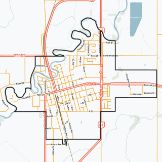
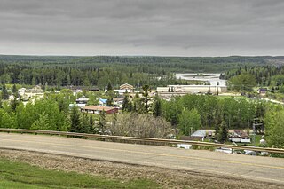
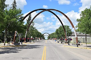
Swan River is a town in Manitoba, Canada. It is surrounded by the Municipality of Swan Valley West in the Swan River Valley region. According to the 2021 Canadian Census, Swan River had a population of 4,049, making it Manitoba's 18th largest in population.
Fort Assiniboine is a hamlet in northwest Alberta, Canada, within Woodlands County. It is located along the north shore of the Athabasca River at the junction of Highway 33 and Highway 661. It is approximately 39 kilometres (24 mi) northwest of Barrhead, 62 kilometres (39 mi) southeast of Swan Hills and 91 kilometres (57 mi) northeast of Whitecourt.

Cartwright is an unincorporated urban community in the Cartwright – Roblin Municipality within the Canadian province of Manitoba that held village status prior to January 1, 2015. It was originally incorporated as a village on December 31, 1947.

Headingley is a rural municipality in Manitoba, Canada. It is located directly west of Winnipeg and had a population of 3,579 people as of the 2016 census.

Carberry is a town in Westman Region of Manitoba, Canada. It is situated 3 kilometres (1.9 mi) south of the Trans-Canada Highway on Highway 5 in the Municipality of North Cypress – Langford, and has a population of 1,818 people.
Alliance is a village in central Alberta, Canada. Established as a station on a Canadian Northern Railway (CNoR) line in 1916, Alliance became a village in 1918. It is located on Highway 602, approximately 160 km (99 mi) east of Red Deer. The village is 2 km (1.2 mi) east of Veterans Memorial Highway and 2.5 km (1.6 mi) north of the Battle River.

Neepawa is a town in Manitoba, Canada, on the Yellowhead Highway at the intersection with Highway 5.
Glenboro is an unincorporated urban community in the Municipality of Glenboro – South Cypress within the Canadian province of Manitoba that held village status prior to January 1, 2015. it is located about 80 km southeast of the City of Brandon. In the 2021 census it had a population of 1,123. The community is a service centre for the surrounding farming community.
Russell is an unincorporated urban community in the Municipality of Russell-Binscarth in Manitoba, Canada.
MacGregor is a community in the Canadian province of Manitoba. It held town status prior to January 1, 2015, when it amalgamated with the Rural Municipality of North Norfolk to form the Municipality of North Norfolk. MacGregor is located approximately 130 km (81 mi) west of Winnipeg and 80 km (50 mi) east of Brandon. It is a farming community, with the biggest industry in the area being agriculture. The community is surrounded by farms, and the Trans-Canada Highway is located just north of MacGregor.

Oak Lake is an unincorporated urban community in the Rural Municipality of Sifton within the Canadian province of Manitoba that held town status prior to January 1, 2015. It is located 52 km (32 mi) west of Brandon along the Trans-Canada Highway. The lake after which it was named is in the rural municipality's western area.
Kamsack, Saskatchewan, Canada, is a town in the Assiniboine River Valley, where the Whitesand River joins the Assiniboine River. It is 56 kilometres (35 mi) northeast of Yorkton. Highway 8 and Highway 5 intersect in the town.

The Rural Municipality of Sifton is a rural municipality (RM) in the south-west portion of the Canadian province of Manitoba.

Waldheim is a town of 1,035 residents in the Rural Municipality of Laird No. 404, in the Canadian province of Saskatchewan, 57 kilometres (35 mi) north of Saskatoon. Waldheim is located on Highway 312 in central Saskatchewan, the "Heart of the Old North-Wes". Fort Carlton, Batoche, Battle of Fish Creek, and Seager Wheeler's Maple Grove Farm are all near Waldheim.
Churchbridge is a town in the province of Saskatchewan, Canada, located at the junction of the Yellowhead Highway, and Highway 80. Churchbridge is a part of the Rural Municipality of Churchbridge No. 211, which is located within Saskatchewan Association of Rural Municipalities (SARM) Division No. 1 and census division Number 5.
Alexander, Manitoba, is a local urban district in the Rural Municipality of Whitehead, situated on Highway 1, west of Brandon.


