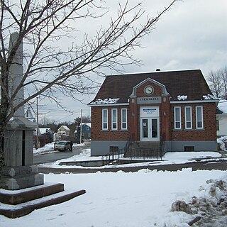
Stewiacke is a town located in southern Colchester County, Nova Scotia, Canada. The town was incorporated on August 30, 1906.

Thunder Bay is a city in and the seat of Thunder Bay District, Ontario, Canada. It is the most populous municipality in Northwestern Ontario and the second most populous municipality in Northern Ontario; its population is 108,843 according to the 2021 Canadian Census. Located on Lake Superior, the census metropolitan area of Thunder Bay has a population of 123,258 and consists of the city of Thunder Bay, the municipalities of Oliver Paipoonge and Neebing, the townships of Shuniah, Conmee, O'Connor, and Gillies, and the Fort William First Nation.
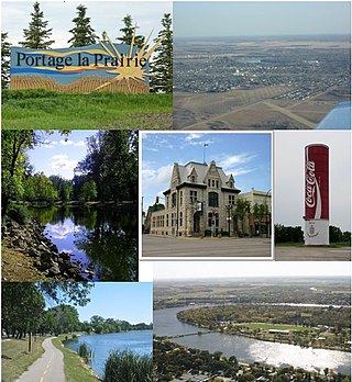
Portage la Prairie is a small city in the Central Plains Region of Manitoba, Canada. As of 2016, the population was 13,304 and the land area of the city was 24.68 square kilometres (9.53 sq mi).

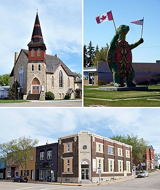
Steinbach is a city located about 58 km (36 mi) south-east of Winnipeg, Manitoba, Canada. Steinbach is the third-largest city in Manitoba, with a population of 17,806, and the largest community in the Eastman region. The city is bordered by the Rural Municipality of Hanover to the north, west, and south, and the Rural Municipality of La Broquerie to the east. Steinbach was first settled by Plautdietsch-speaking Mennonites from Ukraine in 1874, whose descendants continue to have a significant presence in the city today. Steinbach is found on the eastern edge of the Canadian Prairies, while Sandilands Provincial Forest is a short distance east of the city.

Deloraine is an unincorporated urban community in the Municipality of Deloraine – Winchester within the Canadian province of Manitoba that held town status prior to January 1, 2015. It is situated near the Turtle Mountains in the southwestern corner of the province. Located in the Westman Region, the community is 100 km (62 mi) south of Brandon. Deloraine originally incorporated as a village in 1904 and then as a town in 1907. Its town status was relinquished in 2015 when it amalgamated with the Rural Municipality of Winchester.

Winnipegosis is an unincorporated urban community in the Rural Municipality of Mossey River, Manitoba, Canada. It lies at the mouth of the Mossey River on Lake Winnipegosis in west-central Manitoba.
Boissevain is an unincorporated urban community in Manitoba near the North Dakota border that held town status prior to 2015. It is located within the Municipality of Boissevain – Morton. Boissevain is a community of just over 1,500 people and it is located between Killarney and Deloraine on the east and west and Brandon to the north. The population of the surrounding area, within a 50 kilometre radius of the community, is about 15,000.

Cullinan is a small town in the Gauteng province of South Africa. It is located 30 km (19 mi) east of the city of Pretoria along the diamond route and is heavily reliant on tourism and the mine that dominates the skyline. The town is named after diamond magnate Sir Thomas Cullinan.

Darlingford is an unincorporated community recognized as a local urban district located 21 km (13 mi) west of Morden, Manitoba in the Municipality of Pembina in the Pembina Valley region of southern Manitoba, Canada.
Ashern is a local urban district located in the Municipality of West Interlake in Manitoba's Interlake Region.
Arborg is a town located along the Icelandic River in Manitoba. The community is located 103 kilometres north of Winnipeg, at the junction of Manitoba Highways 7 and 68, in the Interlake Region of Manitoba, Canada. The town is surrounded by the Municipality of Bifrost - Riverton and has a population of 1,279 as of the 2021 Canadian census.
Binscarth is an unincorporated urban community in the Municipality of Russell – Binscarth, Manitoba. It is located approximately 167 km (104 mi) northwest of Brandon, 16 km (9.9 mi) south from Russell, and 16 km (10 mi) east of the Saskatchewan border.
Boian is an unincorporated community in Alberta, Canada. It is located in the floodplain of the North Saskatchewan River, 6 km east of Willingdon, in County of Two Hills No. 21. It is the oldest Romanian settlement in Canada.

The County of Warner No. 5 is a municipal district in southern Alberta, Canada. Located in Census Division No. 2 just north of the United States border, its municipal office is located in the Village of Warner.

In geography, statistics and archaeology, a settlement, locality or populated place is a community of people living in a particular place. The complexity of a settlement can range from a minuscule number of dwellings grouped together to the largest of cities with surrounding urbanized areas. Settlements may include hamlets, villages, towns and cities. A settlement may have known historical properties such as the date or era in which it was first settled, or first settled by particular people. The process of settlement involves human migration.

Vela Luka is a small town and a municipality in Dubrovnik-Neretva County in southern Dalmatia, Croatia. The town is located on the western side of the island of Korčula at the bottom of a wide bay which has many indented coves. Vela Luka developed at the beginning of the 19th century in a deep sheltered bay. Its name means "big harbour" in Croatian chakavian. Inhabitants of the Island of Korčula and Pelješac often refer to it simply as "Luka". It has several hotels and a medical centre called Kalos. The inhabitants are farmers, fishermen and workers in tourism. The town also has small industrial plants.
Eriksdale is an unincorporated community located in the Interlake Region of central Manitoba, Canada, near the eastern shore of Lake Manitoba. The community is located on the crossroads of Highway 6 and Highway 68, approximately 118 km (73 mi) north of Winnipeg. It is now a part of the Rural Municipality of West Interlake.

Cooks Creek is an unincorporated community in the Rural Municipality of Springfield, Manitoba, Canada. The community is home to two churches, a community centre and a museum.
Hilltop is a rural community in the Municipality of Clanwilliam – Erickson and is a mixed agricultural area.

Deerwood is a locality in south central Manitoba, Canada. It is located approximately 31 kilometers northwest of Morden, Manitoba in the Rural Municipality of Thompson.


