Mariapolis, Manitoba

Last updated

Mariapolis
Mariapolis church 2.jpg
Our Lady of Assumption Roman Catholic Church in Mariapolis.
Canada Manitoba location map 2.svg
Red pog.svg
Mariapolis
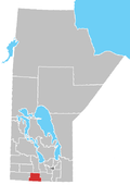
Location of Mariapolis in Manitoba
Coordinates: 49°21′45″N98°59′20″W / 49.36250°N 98.98889°W / 49.36250; -98.98889
Country Flag of Canada (Pantone).svg  Canada
Province Flag of Manitoba.svg  Manitoba
Region Pembina Valley
Census Division No. 4
Government
  Governing BodyMunicipality of Lorne Council
   MP Branden Leslie
   MLA Lauren Stone
Time zone UTC−6 (CST)
  Summer (DST) UTC−5 (CDT)
Postal Code
R0K 1K0
Area code(s) 204, 431
NTS Map062G07
GNBC CodeGAQEJ

Mariapolis AKA the Gateway to Nature, is an unincorporated community recognized as a local urban district [1] located within the Municipality of Lorne in south central Manitoba, Canada. It is located approximately 67 kilometers (42 miles) northwest of Morden. [2]

See also

Related Research Articles

Clearwater is an unincorporated community recognized as a local urban district in south central Manitoba, Canada. It is located in the Municipality of Louise. It plays host to the Harvest Moon Festival each September, a music and organic farming event. Clearwater is also the site of an annual July 1 Canada Day baseball tournament.

St. Claude is an unincorporated community recognized as a local urban district in the Rural Municipality of Grey within the Canadian province of Manitoba that held village status prior to January 1, 2015.

<span class="mw-page-title-main">Baldur, Manitoba</span> Place in Manitoba, Canada

Baldur is an unincorporated community recognized as a local urban district in the Canadian province of Manitoba, located in the Rural Municipality of Argyle. Baldur is the largest community of the municipality, which is in southwestern Manitoba between Brandon and Portage la Prairie. The community is named after the Norse god Baldur.

<span class="mw-page-title-main">Elgin, Manitoba</span> Unincorporated Urban Community

Elgin is an unincorporated community recognized as a local urban district in the Municipality of Grassland in the Canadian province of Manitoba, Canada. It currently has a population of just over 100.

Notre Dame de Lourdes is an unincorporated community recognized as a local urban district in the Municipality of Lorne within the Canadian province of Manitoba that held village status prior to January 1, 2015. It is located within the Central Plains Region, 100 km southwest of Winnipeg. The community had a population of 683 inhabitants in the 2011 census, an increase of 16.0% from the 589 inhabitants during the 2006 census.

Reston is an unincorporated community recognized as a local urban district in southwestern Manitoba, located near the border of Saskatchewan on the west and North Dakota on the south. It is the largest community in the Rural Municipality of Pipestone, which also includes Sinclair, Cromer and Pipestone.

La Rivière is an unincorporated community recognized as a local urban district in Manitoba, Canada. It is located 11 km west of the town of Manitou on Highway 3. It is located in the Municipality of Pembina. La Riviere was founded 1886 by Metis Franco-Manitobans, however it is predominantly English speaking. It has a post office, credit union, a five-lift ski hill, a construction company, and a seasonal drive-in restaurant. It has a full service campground at the edge of the community that backs onto the Pembina River. La Riviere was previously home to Hamm-tone Guitars and Mandolins and the Pembina Valley Guitar Building Course.

<span class="mw-page-title-main">Mather, Manitoba</span> Place in Manitoba, Canada

Mather is an unincorporated community recognized as a local urban district in southwest Manitoba, Canada, and part of Cartwright – Roblin Municipality. The Mather area is known as Crocus Country.

<span class="mw-page-title-main">St. Leon, Manitoba</span>

St. Leon is an unincorporated community recognized as a local urban district in Manitoba, Canada. It is located in the Municipality of Lorne to the southwest of Winnipeg, near the United States border. The community is best known as the site of the St. Leon Wind Farm project.

Altamont is an unincorporated community recognized as a local urban district located within the Municipality of Lorne in south central Manitoba, Canada.

<span class="mw-page-title-main">Ninette, Manitoba</span> Local urban district in Manitoba, Canada

Ninette is an unincorporated community recognized as a local urban district located in Manitoba, Canada at the north end of Pelican Lake. It is located in the Rural Municipality of Prairie Lakes. Ninette has many small businesses, and is known locally for its wide range of sports facilities. In the summer, activities such as boating, fishing, and hunting are offered, while snowmobiling and ice fishing are offered during the wintertime.

<span class="mw-page-title-main">Pierson, Manitoba</span> Local urban district in Manitoba, Canada

Pierson is an unincorporated community recognized as a local urban district located in the Municipality of Two Borders in southwestern Manitoba, Canada. The Antler–Lyleton Border Crossing is located south of Pierson.

<span class="mw-page-title-main">Minto, Manitoba</span>

Minto is an unincorporated community recognized as a local urban district located in the Municipality of Grassland, Manitoba, Canada.

Miniota, Manitoba is an unincorporated community recognized as a local urban district in Prairie View Municipality, Manitoba, Canada. It is located northwest of Virden near the intersection of PTH 83 and PTH 24. The post office opened in 1885 on 36-13-27W. It was originally named Parkisimo and changed to its present name in 1900. It had two railways in its history: the Canadian Pacific Railway and the Grand Trunk Railway. Both had rail points about one mile apart and there was a Miniota Station on the latter.

References

  1. "Local Urban Districts Regulation". Government of Manitoba. April 23, 2016. Retrieved April 24, 2016.
  2. "Geographical Names of Canada - Querying Distances". nrcan.gc.ca. October 24, 2011. Archived from the original on April 16, 2014. Retrieved October 14, 2012.