Kaleida, Manitoba

Last updated

Kaleida
Canada Manitoba location map 2.svg
Red pog.svg
Kaleida
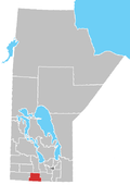
Location of Kaleida in Manitoba
Coordinates: 49°8′45.5″N99°27′4.5″W / 49.145972°N 99.451250°W / 49.145972; -99.451250
Country Flag of Canada (Pantone).svg  Canada
Province Flag of Manitoba.svg  Manitoba
Region Pembina Valley
Census Division No. 4
Government
  Governing BodyMunicipality of Pembina Council
   MP Branden Leslie
   MLA Lauren Stone
Time zone UTC−6 (CST)
  Summer (DST) UTC−5 (CDT)
Area code(s) 204, 431
NTS Map062G01
GNBC CodeGAMLC

Kaleida is an unincorporated community in south central Manitoba, Canada. It is located approximately 28 kilometers (17 miles) southwest of Morden, Manitoba [1] in the Municipality of Pembina. Kaleida has a population of 10 as of June 2021. It is accessible from Provincial Trunk Highway 3 (Boundary Commission Trail) via Provincial Road 528.

See also

Related Research Articles

<span class="mw-page-title-main">Northern Manitoba</span> Region of Manitoba, Canada

Northern Manitoba is a geographic and cultural region of the Canadian province of Manitoba. Originally encompassing a small square around the Red River Colony, the province was extended north to the 60th parallel in 1912. The region's specific boundaries vary, as "northern" communities are considered to share certain social and geographic characteristics, regardless of latitude.

Hugh Borthwick Morrison was a politician in Manitoba, Canada. He served in the Legislative Assembly of Manitoba as a Progressive Conservative from 1936 until the time of his death.

Birds Hill Provincial Park is a provincial park in Manitoba, Canada located in the Boreal Plains ecozone. The park protects areas representative of Aspen/Oak parkland, as well as provides opportunities for recreation. It is located 24 kilometers north of Winnipeg on Highway 59, and covers approximately 8,300 acres or 35.1 km2.

<span class="mw-page-title-main">Rural Municipality of Reynolds</span> Rural municipality in Manitoba, Canada

The Rural Municipality of Reynolds is a rural municipality (RM) in southeastern Manitoba, Canada.

<span class="mw-page-title-main">Rural Municipality of Piney</span> Rural municipality in Manitoba, Canada

The Rural Municipality of Piney is a rural municipality (RM) in southeastern Manitoba, Canada, along the border with Minnesota in the United States.

<span class="mw-page-title-main">Rural Municipality of Victoria</span> Rural municipality in Manitoba, Canada

The Rural Municipality of Victoria is a rural municipality (RM) located in south-central Manitoba, north-east of Glenboro. The RM was established in 1902 and named for Queen Victoria. In its westernmost part, the RM contains parts of Manitoba's Spruce Woods Provincial Forest and Spruce Woods Provincial Park.

<span class="mw-page-title-main">Rural Municipality of Sifton</span> Rural municipality in Manitoba, Canada

The Rural Municipality of Sifton is a rural municipality (RM) in the south-west portion of the Canadian province of Manitoba.

<span class="mw-page-title-main">Politics of Manitoba</span> Political system of Manitoba

The Province of Manitoba, similar to other Canadian provinces and territories, is governed through a Westminster-based parliamentary system. The Manitoba government's authority to conduct provincial affairs is derived from the Constitution of Canada, which divides legislative powers among the federal parliament and the provincial legislatures. Manitoba operates through three branches of government: the executive, the legislative, and the judicial. The executive branch—the Government of Manitoba—consists of the Executive Council and the Premier, who is the head of government and the President of the Executive Council. The legislative branch—the Manitoba Legislature—is composed of the Lieutenant Governor and the Legislative Assembly, which is composed of the 57 members (MLAs) elected to represent the people of Manitoba, as well as the Speaker, the Clerk, the Officers of the Legislative Assembly, and the employees of the legislative service.

The Rural Municipality of Pembina is a former rural municipality (RM) in the Canadian province of Manitoba.

<span class="mw-page-title-main">Rural Municipality of Lac du Bonnet</span> Rural municipality in Manitoba, Canada

Lac du Bonnet is a rural municipality in the province of Manitoba in Western Canada, situated between the Nopiming Provincial Park to the northeast and Whiteshell Provincial Park to the southeast.

<span class="mw-page-title-main">Pembina Valley Provincial Park</span> Provincial park in Manitoba, Canada

Pembina Valley Provincial Park is a provincial park in southern Manitoba, Canada. It is located 47 kilometres south-west of Morden, Manitoba, Canada on Highway 3, Highway 31, and Highway 201, and covers approximately 1.8 square kilometres. The park is considered to be a Class III protected area under the IUCN protected area management categories.

This is a list of elections in Canada in 2010. Included are provincial, municipal and federal elections, by-elections on any level, referendums and party leadership races at any level.

<span class="mw-page-title-main">Municipality of Glenboro-South Cypress</span> Rural municipality in Manitoba, Canada

The Municipality of Glenboro – South Cypress is a rural municipality (RM) in the Canadian province of Manitoba.

<span class="mw-page-title-main">Rural Municipality of Lakeshore</span> Rural municipality in Manitoba, Canada

The Rural Municipality of Lakeshore is a rural municipality (RM) in the Parkland Region of Manitoba, Canada.

<span class="mw-page-title-main">Municipality of Pembina</span> Rural municipality in Manitoba, Canada

The Municipality of Pembina is a rural municipality (RM) in the Canadian province of Manitoba.

<span class="mw-page-title-main">2015 Manitoba municipal amalgamations</span>

The 2015 municipal amalgamations in Manitoba was the result of new legislation in the province that required a minimum population threshold of 1,000 people in order to incorporate a municipality.

Hnausa Beach Provincial Park is a provincial park in Manitoba, Canada, on the west shore of Lake Winnipeg north of Gimli, Manitoba. The beach within the park is named after the nearby community of Hnausa. Hnausa is an Old Icelandic word for a piece of turf. This part of Manitoba is known as New Iceland due to the significant Icelandic settlement of the area that began in 1875.

References

  1. "Geographical Names of Canada - Querying Distances". nrcan.gc.ca. October 24, 2011. Archived from the original on April 16, 2014. Retrieved October 12, 2012.