Cardinal, Manitoba

Last updated • a couple of secsFrom Wikipedia, The Free Encyclopedia

Cardinal
Ste. Therese Chapel.JPG
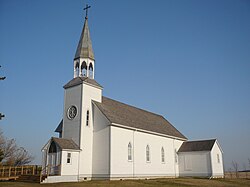
Ste. Thérèse Chapel at Cardinal
Canada Manitoba location map 2.svg
Red pog.svg
Cardinal
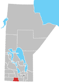
Location of Cardinal in Manitoba
Coordinates: 49°29′41″N98°33′18″W / 49.49472°N 98.55500°W / 49.49472; -98.55500
Country Flag of Canada (Pantone).svg  Canada
Province Flag of Manitoba.svg  Manitoba
Region Pembina Valley
Census Division No. 4
Government
  Governing BodyMunicipality of Lorne Council
   MP Branden Leslie
   MLA Lauren Stone
Time zone UTC−6 (CST)
  Summer (DST) UTC−5 (CDT)
Area code(s) 204, 431
NTS Map062G07
GNBC CodeGAEJG

Cardinal is an unincorporated community located in the Municipality of Lorne in south central Manitoba, Canada. It is located approximately 110 kilometers (68 miles) southwest of Winnipeg, [1] on the west side of Provincial Road 244.

See also

Related Research Articles

Roblin is an unincorporated urban community in the Municipality of Roblin, Manitoba, Canada. It is located approximately 400 km (250 mi) northwest of Winnipeg.

The Rural Municipality of Albert is a former rural municipality (RM) in the Canadian province of Manitoba. It was originally incorporated as a rural municipality on December 1, 1905. It ceased on January 1, 2015 as a result of its provincially mandated amalgamation with the RM of Arthur and the RM of Edward to form the Municipality of Two Borders.

<span class="mw-page-title-main">Rural Municipality of Headingley</span> Rural municipality in Manitoba, Canada

Headingley is a rural municipality in Manitoba, Canada. It is located directly west of Winnipeg and had a population of 3,579 people as of the 2016 census.

<span class="mw-page-title-main">Fort Garry, Winnipeg</span> Suburb of Winnipeg, Canada

Fort Garry is a community area and neighbourhood of Winnipeg, Manitoba, Canada, located in the southwestern part of the city, south of the district of Fort Rouge and east of the Tuxedo area. It comprises parts of the city wards of River Heights - Fort Garry, Fort Rouge - East Fort Garry, Waverley West, and St. Norbert - Seine River.

<span class="mw-page-title-main">Rural Municipality of Ritchot</span> Rural municipality in Manitoba, Canada

The Rural Municipality of Ritchot is a rural municipality (RM) in the Winnipeg Capital Region, bordering the south side of Winnipeg in Manitoba, Canada. The separately-administered town of Niverville lies adjacent to its southeast, between it and the Rural Municipality of Hanover.

<span class="mw-page-title-main">Waskada</span> Former village in Manitoba, Canada

Waskada is an unincorporated urban community in the Municipality of Brenda – Waskada within the Canadian province of Manitoba that held village status prior to January 1, 2015. It is located in the southwest corner of the province, close to the United States and Saskatchewan borders. It was settled as early as 1883 and incorporated as a village in 1948. Waskada has a population of 183, and covers a land area of 0.77 km2. Though traditionally a farming community, a recent oil boom has also brought economic activity to the area.

<span class="mw-page-title-main">Demographics of Manitoba</span>

Manitoba is one of Canada's 10 provinces. It is the easternmost of the three Prairie provinces.

The Rural Municipality of Miniota is a former rural municipality (RM) in the Canadian province of Manitoba. It was originally incorporated as a rural municipality on December 22, 1883. It ceased on January 1, 2015 as a result of its provincially mandated amalgamation with the RM of Birtle and the Town of Birtle to form the Prairie View Municipality.

<span class="mw-page-title-main">Rural Municipality of Prairie Lakes</span> Rural municipality in Manitoba, Canada

The Rural Municipality of Prairie Lakes is a rural municipality (RM) in the Canadian province of Manitoba. The Rural Municipality of Prairies lakes surrounds most of the north end of Pelican Lake. There are several other lakes in the RM such as Grass Lake, Overend Lake, Bone Lake, Lorne Lake, Louise Lake, Lloyds Lake, Noble Lake and many more that are all much smaller than Pelican Lake.

<span class="mw-page-title-main">2015 Manitoba municipal amalgamations</span>

The 2015 municipal amalgamations in Manitoba was the result of new legislation in the province that required a minimum population threshold of 1,000 people in order to incorporate a municipality.

References

  1. "Geographical Names of Canada – Querying Distances". nrcan.gc.ca. Archived from the original on December 19, 2013. Retrieved December 17, 2013.