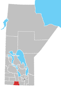
The Winnipeg Metropolitan Region is a metropolitan area in the Canadian province of Manitoba located in the Red River Valley in the southeast portion of the province of Manitoba, Canada. It contains the provincial capital of Winnipeg and 17 surrounding rural municipalities, cities, and towns.

West St. Paul is a rural municipality (RM) in Manitoba, Canada. It lies adjacent to the north side of Winnipeg, and directly west of the Red River. It is part of the Winnipeg Metro Region, and had a population of 5,368 at the 2016 census.

The Rural Municipality of Sifton is a rural municipality (RM) in the south-west portion of the Canadian province of Manitoba.

Manitoba is one of Canada's 10 provinces. It is the easternmost of the three Prairie provinces.

The Province of Manitoba, similar to other Canadian provinces and territories, is governed through a Westminster-based parliamentary system. The Manitoba government's authority to conduct provincial affairs is derived from the Constitution of Canada, which divides legislative powers among the federal parliament and the provincial legislatures. Manitoba operates through three levels of government: the executive, the legislative, and the judiciary. The executive branch—the Executive Council of Manitoba—consists of the Premier, who is the head of government and the President of the Executive Council. The legislative branch—Manitoba Legislature—consists of the Speaker and elected members, who are served by the Clerk, the Officers of the Legislative Assembly, and the employees of the legislative service. The Legislative Assembly consists of the 57 members (MLAs) elected to represent the people of Manitoba.

The Rural Municipality of Prairie Lakes is a rural municipality (RM) in the Canadian province of Manitoba. The Rural Municipality of Prairies lakes surrounds most of the north end of Pelican Lake. There are several other lakes in the RM such as Grass Lake, Overend Lake, Bone Lake, Lorne Lake, Louise Lake, Lloyds Lake, Noble Lake and many more that are all much smaller than Pelican Lake.

The Municipality of Two Borders is a rural municipality (RM) in the Canadian province of Manitoba. It is located in the extreme south-west corner of the province in the Westman Region.

The 2015 municipal amalgamations in Manitoba was the result of new legislation in the province that required a minimum population threshold of 1,000 people in order to incorporate a municipality.


