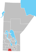
Baldur, Manitoba

Last updated

Baldur
Baldur Manitoba.JPG
The grain elevator and Veteran Park in Baldur.
Canada Manitoba location map 2.svg
Red pog.svg
Baldur
Coordinates: 49°23′08″N99°14′37″W / 49.38556°N 99.24361°W / 49.38556; -99.24361
Country Canada
Province Manitoba
Area
  Total2.21 km2 (0.85 sq mi)
Population
 (2016) [1]
  Total320
  Density144.9/km2 (375/sq mi)
Time zone UTC−5 (CST)
  Summer (DST) UTC−6 (CDT)

Baldur is an unincorporated community recognized as a local urban district in the Canadian province of Manitoba, located in the Rural Municipality of Argyle. [2] Baldur is the largest community of the municipality, which is in southwestern Manitoba between Brandon and Portage la Prairie. The community is named after the Norse god Baldur. [3]

Contents

History

The community was founded in 1890 with the coming of the railway. Its name reflects the Icelandic heritage of the people in the community.

Demographics

In the 2021 Census of Population conducted by Statistics Canada, Baldur had a population of 297 living in 146 of its 155 total private dwellings, a change of

Notable people

Climate

Climate data for Baldur
MonthJanFebMarAprMayJunJulAugSepOctNovDecYear
Record high °C (°F)8.9
(48.0)
13.5
(56.3)
21.7
(71.1)
36
(97)
37
(99)
37.2
(99.0)
37.8
(100.0)
39.5
(103.1)
38.3
(100.9)
34
(93)
24.5
(76.1)
15.6
(60.1)
39.5
(103.1)
Average high °C (°F)−10.7
(12.7)
−6.9
(19.6)
−0.4
(31.3)
10.4
(50.7)
19
(66)
23.1
(73.6)
25.6
(78.1)
25.4
(77.7)
18.8
(65.8)
11.4
(52.5)
0
(32)
−8.2
(17.2)
9
(48)
Daily mean °C (°F)−16.4
(2.5)
−12.7
(9.1)
−5.9
(21.4)
3.6
(38.5)
11.6
(52.9)
16.4
(61.5)
18.8
(65.8)
18
(64)
11.9
(53.4)
4.9
(40.8)
−4.9
(23.2)
−13.5
(7.7)
2.6
(36.7)
Average low °C (°F)−22.1
(−7.8)
−18.5
(−1.3)
−11.4
(11.5)
−3.1
(26.4)
4.2
(39.6)
9.6
(49.3)
12
(54)
10.5
(50.9)
4.9
(40.8)
−1.5
(29.3)
−9.8
(14.4)
−18.8
(−1.8)
−3.7
(25.3)
Record low °C (°F)−41.1
(−42.0)
−42.5
(−44.5)
−36
(−33)
−29.4
(−20.9)
−10.6
(12.9)
−2.8
(27.0)
1.1
(34.0)
−4
(25)
−7.8
(18.0)
−22.5
(−8.5)
−35.5
(−31.9)
−39
(−38)
−42.5
(−44.5)
Average precipitation mm (inches)22.9
(0.90)
23.4
(0.92)
26.4
(1.04)
32.2
(1.27)
62.6
(2.46)
91.7
(3.61)
69.2
(2.72)
73.8
(2.91)
49.8
(1.96)
39.3
(1.55)
26.8
(1.06)
25.4
(1.00)
542.5
(21.36)
Source: Environment Canada [5]

See also

Related Research Articles

<span class="mw-page-title-main">Elm Creek, Manitoba</span> Local urban district in Manitoba, Canada

Elm Creek is an unincorporated community recognized as a local urban district in Manitoba, Canada. It is about 50 km west of Winnipeg and about 35 km southeast of Portage la Prairie. It is located in the Rural Municipality of Grey. It is home to the second largest fire hydrant in the world which was unveiled on Canada Day, 2001. It is also the home of the second largest H4 chondrite ever found in Canada. The 8.2-kg mass was found by a local grader driver on a rural road in 1997. Elm Creek has a Kindergarten to Grade 12 school.

Plum Coulee is an unincorporated urban community in the Municipality of Rhineland within the Canadian province of Manitoba that held town status prior to January 1, 2015. It is west of Altona, one hour southwest of Winnipeg and 22 kilometres from the United States border. It is also the former home to the Plum Coulee Xpress hockey club. It has an artificial beach located in town called Sunset Beach.

Ashern is a local urban district located in the Municipality of West Interlake in Manitoba's Interlake Region.

Lundar is a local urban district in the Rural Municipality of Coldwell, Manitoba, Canada. Located in Manitoba's Interlake Region, it is situated 99 km (62 mi) north of Winnipeg on Highway 6.

<span class="mw-page-title-main">Pilot Mound, Manitoba</span> Place in Manitoba, Canada

Pilot Mound is an unincorporated community recognized as a local urban district that also once held town status in the Canadian province of Manitoba. It is located within the Municipality of Louise, approximately 60 km west of the City of Morden.

Binscarth is an unincorporated urban community in the Municipality of Russell – Binscarth, Manitoba. It is located approximately 167 km (104 mi) northwest of Brandon, 16 km (9.9 mi) south from Russell, and 16 km (10 mi) east of the Saskatchewan border.

Birch River is a local urban district in the northern portion of the Rural Municipality of Mountain, Manitoba, Canada. It is around 40 kilometers from Swan River, Manitoba.

Fisher Branch is an unincorporated community recognized as a local urban district in the Rural Municipality of Fisher in the Canadian province of Manitoba. It is located on Highway 17 in the north Interlake Region of the province. Fisher Branch was originally named Wasoo, but later was changed to Fisher Branch because it was beside a branch of the Fisher River. The primary industry of Fisher Branch is agriculture.

<span class="mw-page-title-main">Gladstone, Manitoba</span> Unincorporated community in Manitoba, Canada

Gladstone is an unincorporated urban community in the Municipality of WestLake – Gladstone within the Canadian province of Manitoba that held town status prior to January 1, 2015. It is located on the Yellowhead Highway at the intersection with Highway 34. The Gladstone railway station receives Via Rail service.

Pelly is a village in the Canadian province of Saskatchewan within the Rural Municipality of St. Philips No. 301 and Census Division No. 9.

Powerview-Pine Falls is a town in the Canadian province of Manitoba, with a population of 1,314 at the 2011 census, up 1.54% from 1,294 at the 2006 census and down 7.57% from 1,400 during the 2001 census.

<span class="mw-page-title-main">Somerset, Manitoba</span> Place in Manitoba, Canada

Somerset is an unincorporated community recognized as a local urban district in the Municipality of Lorne within the Canadian province of Manitoba that held village status prior to January 1, 2015.

Semans is a village in the Canadian province of Saskatchewan within the Rural Municipality of Mount Hope No. 279 and Census Division No. 10. The village is located approximately 125 km north of the City of Regina and 195 km southeast of the City of Saskatoon.

<span class="mw-page-title-main">Stony Mountain, Manitoba</span> Unincorporated Community in Manitoba, Canada

Stony Mountain is a small community in Manitoba, Canada approximately 11 kilometres (6.8 mi) north of Winnipeg on Provincial Highway 7. The town is in the Rural Municipality of Rockwood and is the location of Stony Mountain Ski Area. The Stony Mountain Institution and Rockwood Institution prisons are in Stony Mountain.

<span class="mw-page-title-main">Rural Municipality of Coldwell</span> Rural municipality in Manitoba, Canada

The Rural Municipality of Coldwell is a rural municipality in the Interlake Region of the province of Manitoba in Western Canada. The principal community within the boundaries is Lundar.

<span class="mw-page-title-main">Rural Municipality of Woodlands</span> Rural municipality in Manitoba, Canada

Woodlands is a rural municipality (RM) in the province of Manitoba in Western Canada. It lies in the southern part of the Interlake and is named for the community of Woodlands, which itself is named for the wooded lands of the area.

<span class="mw-page-title-main">Waterton Park</span> Community in Alberta, Canada

Waterton Park, commonly referred to as Waterton, is a hamlet in southwestern Alberta, Canada within Improvement District No. 4 Waterton.

<span class="mw-page-title-main">Ninette, Manitoba</span> Local urban district in Manitoba, Canada

Ninette is an unincorporated community recognized as a local urban district located in Manitoba, Canada at the north end of Pelican Lake. It is located in the Rural Municipality of Prairie Lakes. Ninette has many small businesses, and is known locally for its wide range of sports facilities. In the summer, activities such as boating, fishing, and hunting are offered, while snowmobiling and ice fishing are offered during the wintertime.

<span class="mw-page-title-main">Pierson, Manitoba</span> Local urban district in Manitoba, Canada

Pierson is an unincorporated community recognized as a local urban district located in the Municipality of Two Borders in southwestern Manitoba, Canada. The Antler–Lyleton Border Crossing is located south of Pierson.

Ranfurly is a hamlet in central Alberta, Canada within the County of Minburn No. 27. Previously an incorporated municipality, Ranfurly dissolved from village status on January 1, 1946 to become part of the Municipal District of Birch Lake No. 484.

References

  1. "Census Profile". 2016 Census . Statistics Canada. February 8, 2017.
  2. "Local Urban Districts Regulation". Government of Manitoba. April 23, 2016. Retrieved April 24, 2016.
  3. "Town of Baldur website" . Retrieved January 11, 2019.
  4. "Population and dwelling counts: Canada and designated places". Statistics Canada. February 9, 2022. Retrieved September 3, 2022.
  5. Environment Canada - Canadian Climate Normals 1971-2000—Canadian Climate Normals 1971–2000, accessed 08 March 2011