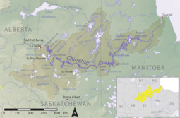
Prince Albert National Park encompasses 3,874 square kilometres (1,496 sq mi) in central Saskatchewan, Canada and is located 200 kilometres (120 mi) north of Saskatoon. Though declared a national park March 24, 1927, official opening ceremonies weren't performed by Prime Minister William Lyon Mackenzie King until August 10, 1928. This park is open all year but the most visited period is from May to September. Although named for the city of Prince Albert, the park's main entrance is actually 80 km (50 mi) north of that city via Highways 2 and 263, which enters the park at its southeast corner. Two additional secondary highways enter the park, Highway 264, which branches off Highway 2 just east of the Waskesiu townsite, and Highway 240, which enters the park from the south and links with 263 just outside the entry fee-collection gates. Prince Albert National Park is not located within any rural municipality, and is politically separate from the adjacent Northern Saskatchewan Administration District (NSAD). Until the establishment of Grasslands National Park in 1981, it was the province's only national park.
Sturgeon Lake is lake in the Canadian province of Saskatchewan. It is a small, narrow body of water situated in the transition zone between the aspen parkland and boreal forest biomes. It is located along the course of Sturgeon River, which has its headwaters in Prince Albert National Park and the Waskesiu Hills. The Sturgeon River is a tributary of the North Saskatchewan River. A small dam at the eastern end of the lake helps regulate water levels.
Waskesiu Lake is a lake located roughly in the centre of Prince Albert National Park. The lake's name means red deer or elk in the Cree language. Waskesiu Lake is by far the most developed lake in the park, and features a variety of recreational facilities along all sides of its shoreline, including camping, golfing, boating, and hiking. The resort village of Waskesiu Lake is on its eastern shore. The Prince Albert National Park Nature Centre is located in the village as well as many other amenities such as lodging, police, a gas station, shopping, and restaurants. Access to the lake is from Highways 263 and 264.

Amisk Lake is a lake in the east-central part of the Canadian province of Saskatchewan, about 22 kilometres (14 mi) south-west of Flin Flon, Manitoba. 'Amisk' means beaver in Cree. Saskatchewan Highway 167 provides road access. Denare Beach, the largest settlement, is located at the north-east corner of the lake.
Montreal Lake is a lake in the north-central part of Canadian province of Saskatchewan. It is the source of the Montreal River and is located between Highways 2 and 969. Prince Albert National Park is to the west and Clarence-Steepbank Lakes Provincial Park is to the east. Communities on the lake include Montreal Lake, Timber Bay, and Molanosa.

Montreal River is a river in the Canadian province of Saskatchewan. It flows 100 kilometres (62 mi) from Montreal Lake to Lac la Ronge and is part of the Churchill River and Hudson Bay drainage basins. Along its course, Montreal River runs through boreal forests, muskeg, and glacier formed valleys. Within its watershed are the Waskesiu Uplands, much of Prince Albert National Park, and several notable lakes, such as Waskesiu, Kingsmere, Crean, Weyakwin, and Bittern.

Sturgeon River is a river in the Hudson Bay drainage basin in the central part of the Canadian province of Saskatchewan. It flows from its source in the Waskesiu Hills in Prince Albert National Park to the North Saskatchewan River, just west of the city of Prince Albert.

Lac La Ronge Provincial Park is located in the boreal forest of the north central part of the Canadian province of Saskatchewan within the Canadian Shield. Situated in the Churchill River system, this provincial park has close to 100 lakes and more than 30 canoe routes, many of which follow old fur trade routes. Summer activities include camping, hiking, boating, fishing, and swimming. In the winter, there's cross-country skiing, snowmobiling, and ice fishing. Saskatchewan's highest waterfall is in the park. Nistowiak Falls are located north of Lac La Ronge along the Rapid River.

Saskatchewan Landing Provincial Park is a provincial park in the Canadian province of Saskatchewan. It is located in the valley of the South Saskatchewan River at the western end of Lake Diefenbaker in the RM of Saskatchewan Landing No. 167, about 50 kilometres (31 mi) north of Swift Current. The park is 5,735 ha in size.
The Cub Hills are a hilly plateau located south-east of the geographical centre of the Canadian province of Saskatchewan. The hills are in the boreal forest ecozone of Canada and the landforms of the hills were shaped more than 10,000 years ago during last ice age. Throughout the Cub Hills, there are dozens of lakes and rivers and several parks. The Cubs Hills are 150 km (93 mi) north-east of Prince Albert and are in the Northern Saskatchewan Administration District and Census Division #18. Several highways criss-cross the plateau to provide access to the various parks and other amenities.
Cowan River is a river in the west-central part of the Canadian province of Saskatchewan in the boreal forest ecozone of Canada. The river begins at Cowan Lake Dam near the northern end of Cowan Lake and flows north-west through muskeg and forest to meet Beaver River. Beaver River then flows into Lac Île-à-la-Crosse and the Churchill River. The entirety of Cowen River is within the Northern Saskatchewan Administration District and while there are no communities along its course, the towns of Big River and Spiritwood are in its watershed.
Clarence-Steepbank Lakes Provincial Park is a remote wilderness park in the Canadian province of Saskatchewan. It is located in the boreal forest ecozone east of Prince Albert National Park and Montreal Lake, west of the Cub Hills and Narrow Hills Provincial Park, south of Nipekamew and East Trout Lakes, and north of Whiteswan Lakes and Candle Lake Provincial Park. The city of Prince Albert is approximately 150 kilometres (93 mi) to the south and access to the park is from Highway 927.
Great Blue Heron Provincial Park is a recreational park in the central region of the Canadian province of Saskatchewan in the boreal forest ecozone of Canada. It is adjacent to the eastern boundary of Prince Albert National Park, about 50 kilometres (31 mi) north of the city of Prince Albert. The provincial park was established in 2013 from two pre-existing provincial recreation sites – Emma Lake and Anglin Lake Recreation Sites – and the addition of a large tract of Crown land.
Spruce River, also called Little Red River, is a river in the north-central region of the Canadian province of Saskatchewan. It begins in the Waskesiu Hills in Prince Albert National Park and flows generally in a southward direction through boreal forests, glacier carved hills and valleys, muskeg, and prairie en route to the North Saskatchewan River at the east end of the city of Prince Albert.
Waskesiu Upland is a hilly plateau in the central region of the Canadian province of Saskatchewan. Waskesiu means red deer or elk in the Cree language. The plateau is just south-west of the geographical centre of the province and consists of two main ranges — the Waskesiu Hills to the south and the Thunder Hills to the north. The Thunder Hills cover an area of about 225,000 acres. Several notable rivers begin from the upland with ones headed south flowing into the North Saskatchewan River and ones headed north flowing into the Churchill River. Much of the plateau is carpeted in boreal forests and most of the Waskesiu Hills range is within Prince Albert National Park. Besides the national park, there are several provincial recreation sites in and around the upland. The northern part of the upland is part of the Northern Saskatchewan Administration District and is sparsely populated.
Beatty Lake is a lake in the Canadian province of Saskatchewan. The lake is set in rolling hills of Jack pine forest and muskeg in Saskatchewan's Northern Administration District. The lake is adjacent to Beaver River near where Beatty Creek flows into Beaver River. Access is from the Hanson Lake Road.
Delaronde Lake is a lake in the Canadian province of Saskatchewan. It is situated at the western edge of the Waskesiu Upland in the boreal forest ecozone of Canada. Delaronde Lake is within the Churchill River drainage basin of the Hudson Bay.
Nesslin Lake is a lake in the Canadian province of Saskatchewan. It is situated at the western end of the Waskesiu Upland in the boreal forest ecozone of Canada. Nesslin Lake is within the Churchill River drainage basin of the Hudson Bay.
Ness Lakes are a group of five interconnected lakes — the largest of which is Ness Lake — in the Canadian province of Saskatchewan. They are in the Rural Municipality of Big River No. 555 at the western end of the Waskesiu Hills in the boreal forest ecozone of Canada. The western boundary of Prince Albert National Park is directly to the east and the town of Big River is about 15 kilometres (9.3 mi) to the south-west. Access to the lakes is from Nesslin Lake Road, which branches off of Highway 922.
MacLennan River is a river in the Canadian province of Saskatchewan. It begins at MacLennan Lake in the Thunder Hills of the Northern Saskatchewan Administration District. It then flows generally south-east out of the hills, through a section of Prince Albert National Park, and on to Montreal Lake. MacLennan River is within the Churchill River drainage basin and is in the Mid-Boreal Upland ecozone of Canada.