Beaver River is a large river in east-central Alberta and central Saskatchewan, Canada. It flows east through Alberta and Saskatchewan and then turns sharply north to flow into Lac Île-à-la-Crosse on the Churchill River which flows into Hudson Bay.

Wollaston Lake is a lake in north-eastern part of the Canadian province of Saskatchewan. It is about 550 kilometres (340 mi) north-east of Prince Albert. With a surface area of 2,286 square kilometres (883 sq mi), it is the largest bifurcation lake in the world – that is, a lake that drains naturally in two directions.
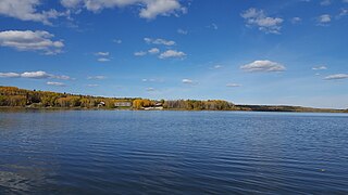
Missinipe, meaning "big water" or "difficult river", is a northern settlement in northern Saskatchewan located in Treaty 10 territory and along the western shore of Otter Lake. The hamlet is situated 80 km (50 mi) north of La Ronge along Saskatchewan Highway 102.The hamlet is located within the Northern Saskatchewan Administration District and the provincial Census Division No. 18.
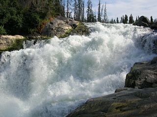
Nistowiak Falls, at 10 metres (33 ft), is one of the highest waterfalls in the province of Saskatchewan, Canada. The falls are on the Rapid River, which flows north from Iskwatikan Lake into Nistowiak Lake on the Churchill River. Nistowiak is a Cree word referring to the convergence of waters.
The Lac La Ronge Indian Band is a Woodland Cree First Nation in northern Saskatchewan, it is the largest Cree band government in Canada and the largest First Nation in Saskatchewan. The administrative centre of the Lac La Ronge Indian Band is located in La Ronge.

Stanley Mission is a First Nations settlement in the boreal forest northern Saskatchewan, Canada. Its location is on the banks of the Churchill River, 80 kilometres (50 mi) northeast of the town of La Ronge, 305 kilometres (190 mi) north of Prince Albert. Access is provided by Highway 915.

Lac la Ronge is a glacial lake in the Canadian province of Saskatchewan. It is the fifth largest lake in the province and is approximately 250 kilometres (160 mi) north of Prince Albert, on the edge of the Canadian Shield. La Ronge, Air Ronge, and the Lac La Ronge First Nation are on the western shore. The lake is a popular vacation spot. Recreational activities include fishing, boating, canoeing, hiking, and camping.
Montreal Lake is a lake in the north-central part of Canadian province of Saskatchewan. It is the source of the Montreal River and is located between Highways 2 and 969. Prince Albert National Park is to the west and Clarence-Steepbank Lakes Provincial Park is to the east. Communities on the lake include Montreal Lake, Timber Bay, and Molanosa.

Narrow Hills Provincial Park is a northern boreal forest provincial recreational park in the Canadian province of Saskatchewan. It is located in a hilly plateau called the Cub Hills and contains several recreational facilities and over 25 accessible lakes within its boundaries. The geographical features of the park, including the lakes, valleys, and lowlands were formed over 10,000 years ago during the last ice age. The town of Smeaton is the closest community and it is located 70 kilometres (43 mi) to the south.
Nemeiben Lake is a hamlet in north-central Saskatchewan, Canada. Part of the lake enclosed within the hamlet is located in the Lac La Ronge Provincial Park. It is 2 km from Lac la Ronge and 24 km from the town of La Ronge.
Rapid River is a short river in central Saskatchewan, Canada, about 13 kilometres (8 mi) east of the community of Stanley Mission. It is part of the Churchill River drainage basin. The river is about 1,000 metres (3,281 ft) long and flows north from Iskwatikan Lake, which lies downstream from Lac la Ronge, over the Nistowiak Falls, one of the tallest in Saskatchewan, and the Fisher Rapids, to Nistowiak Lake on the Churchill River, which flows to Hudson Bay. The entire river is within Lac La Ronge Provincial Park. At the mouth of the river, on Nistowiak Lake, is the Stanley 157A Indian reserve.

Montreal River is a river in the Canadian province of Saskatchewan. It flows 100 kilometres (62 mi) from Montreal Lake to Lac la Ronge and is part of the Churchill River and Hudson Bay drainage basins. Along its course, Montreal River runs through boreal forests, muskeg, and glacier formed valleys. Within its watershed are the Waskesiu Uplands, much of Prince Albert National Park, and several notable lakes, such as Waskesiu, Kingsmere, Crean, Weyakwin, and Bittern.

Waterhen River is an east-flowing river in the north-west area of the Canadian province of Saskatchewan in the drainage basin of the Beaver River. It is north of and parallel to the east-flowing part of the Beaver River and joins the north-flowing part of that river. Most of the river and its drainage basin is at the southern edge of the boreal forest belt. While the river's source is Lac des Îles, its drainage basin reaches north into the Mostoos Hills and west well into the neighbouring province of Alberta.

Lac La Ronge Provincial Park is located in the boreal forest of the north central part of the Canadian province of Saskatchewan within the Canadian Shield. Situated in the Churchill River system, this provincial park has close to 100 lakes and more than 30 canoe routes, many of which follow old fur trade routes. Summer activities include camping, hiking, boating, fishing, and swimming. In the winter, there's cross-country skiing, snowmobiling, and ice fishing. Saskatchewan's highest waterfall is in the park. Nistowiak Falls are located north of Lac La Ronge along the Rapid River.
Nipekamew River is a river in the Canadian province of Saskatchewan. The river's source is Nipekamew Lake at the north-western edge of the Cub Hills and its mouth is in Nipekamew Bay at the southern shore of Lac la Ronge. From the northern tip of Nipekamew Lake, the river travels from south to north through muskeg and boreal forest en route to Lac la Ronge. Lake la Ronge empties north into the Churchill River through Rapid River.
East Trout Lake is a lake in the Canadian province of Saskatchewan. The lake is directly north of Clarence-Steepbank Lakes Provincial Park in Saskatchewan's Northern Administration District. It is a long and narrow lake that runs in a west to east direction and is surrounded by boreal forest, rolling hills, and muskeg. Several streams flow into the lake and its outflow is at the eastern end where it flows directly into neighbouring Nipekamew Lake through a short channel and bay. The lake is part of the Churchill River watershed, which flows into the Hudson Bay.
The Cub Hills are a hilly plateau located south-east of the geographical centre of the Canadian province of Saskatchewan. The hills are in the boreal forest ecozone of Canada and the landforms of the hills were shaped more than 10,000 years ago during last ice age. Throughout the Cub Hills, there are dozens of lakes and rivers and several parks. The Cubs Hills are 150 km (93 mi) north-east of Prince Albert and are in the Northern Saskatchewan Administration District and Census Division #18. Several highways criss-cross the plateau to provide access to the various parks and other amenities.
Clarence-Steepbank Lakes Provincial Park is a remote wilderness park in the Canadian province of Saskatchewan. It is located in the boreal forest ecozone east of Prince Albert National Park and Montreal Lake, west of the Cub Hills and Narrow Hills Provincial Park, south of Nipekamew and East Trout Lakes, and north of Whiteswan Lakes and Candle Lake Provincial Park. The city of Prince Albert is approximately 150 kilometres (93 mi) to the south and access to the park is from Highway 927.
Clarence Lake is a lake in Clarence-Steepbank Lakes Provincial Park in the Canadian province of Saskatchewan. The lake is in a glacier-carved valley in the Boreal forest ecozone of Canada and is part of the Bow River chain of lakes at the headwaters of the Bow River, which is a tributary of Lac la Ronge in the Churchill River watershed.
Steepbank Lake is a lake in Clarence-Steepbank Lakes Provincial Park in the Canadian province of Saskatchewan. The lake is in a glacier-carved valley in the Boreal forest ecozone of Canada and is part of the Bow River chain of lakes near the headwaters of the Bow River, which is a tributary of Lac la Ronge in the Churchill River watershed.