
Lake Athabasca is in the north-west corner of Saskatchewan and the north-east corner of Alberta between 58° and 60° N in Canada. The lake is 26% in Alberta and 74% in Saskatchewan.
The Mississagi River is a river in Algoma and Sudbury Districts, Ontario, Canada, that originates in Sudbury District and flows 266 kilometres (165 mi) to Lake Huron at Blind River, Algoma District.
The Moira River is a river in Hastings County in eastern Ontario, Canada. It travels from its source in the centre of the county to the Bay of Quinte at the county seat Belleville.
The Fond du Lac River is one of the upper branches of the Mackenzie River system, draining into the Arctic Ocean, located in northern Saskatchewan, Canada. The river is 277 kilometres (172 mi) long, has a watershed of 66,800 km2 (25,800 sq mi), and its mean discharge is 300 m3/s (11,000 cu ft/s).

The Hayes River is a river in Northern Manitoba, Canada, that flows from Molson Lake to Hudson Bay at York Factory. It was historically an important river in the development of Canada and is now a Canadian Heritage River and the longest naturally flowing river in Manitoba.

Trout River is a river in the Northwest Territories of Canada. It is a major tributary of the Mackenzie River.
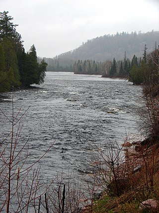
The Rapid River is a river in Algoma District, Ontario, Canada. The river is about 15 kilometres (9 mi) long and begins at Seymour Lake at an elevation of 410 metres (1,345 ft). It travels west and takes in its left tributary the Little Rapid River at an elevation of 408 metres (1,339 ft). The river continues west over a small rapids and a waterfall before emptying into the Mississagi River at an elevation of 314 metres (1,030 ft). A road, which begins at Highway 129 north of the river's mouth, parallels the majority of the river to Seymour Lake.
The Mink River is a river in the Hudson Bay drainage basin in Census Division No. 22 - Thompson-North Central, Northern Region, Manitoba, Canada. It is about 14.7 kilometres (9.1 mi) long and begins at Aswapiswanan Lake at an elevation of 186 metres (610 ft). The river takes in one significant tributary, an unnamed river from the Colen Lakes, from the left at 54°29′57″N95°13′06″W before emptying into Touchwood Lake at an elevation of 184 metres (604 ft). The Mink River's waters eventually flow into Gods Lake, and via the Gods River and the Hayes River into Hudson Bay.
The Ekwan River is a river in Kenora District in northwestern Ontario, Canada. It appears as Equam on Bellin map of 1744. Ekwan River is of Cree origin, meaning "the river far up the coast". It travels about 500 kilometres (311 mi) from its source at Zumar Lake on the Canadian Shield, through the Hudson Bay Lowlands, northeast and then east, to its mouth on James Bay.
Bolton Lake is a lake in the Mackenzie River drainage basin in north-western Saskatchewan, Canada. It is about 2.7 kilometres (1.7 mi) long and 1.3 kilometres (0.81 mi) wide, and lies at an elevation of 487 metres (1,598 ft). The primary outflow is an unnamed creek to Meanwell Lake, then an unnamed creek into the Mirror River, and then via Clearwater River, Athabasca River, Slave River, and Mackenzie River into the Arctic Ocean.
The Rapid River is a river in Sudbury District and Greater Sudbury in Northwestern Ontario, Canada. It begins at an unnamed marsh, at an elevation of 430 metres (1,411 ft) and just upstream of Osbourne Lake, in Unorganized Sudbury, Sudbury District. It travels south to its mouth at the Vermillion River at an elevation of 282 metres (925 ft), near the community of Val Thérèse in Greater Sudbury.

Black Lake is a lake in the Mackenzie River drainage basin in northern Saskatchewan, Canada. It is about 55 kilometres (34 mi) long, 17 kilometres (11 mi) wide, has an area of 464 km2 (179 sq mi), and lies at an elevation of 281 metres (922 ft). The primary inflows are the Chipman River, Cree River, Fond du Lac River, and Souter River; the primary outflow is Fond du Lac River, which flows via the Mackenzie River into the Arctic Ocean.
Partridge Creek is a creek in the Moira River and Lake Ontario drainage basins in Hastings and Lennox and Addington Counties, Ontario, Canada.
The Clare River is a river that is part of the Moira River system in the Lake Ontario drainage basin in Hastings and Lennox and Addington Counties, Ontario, Canada.
Chrysal Creek is a creek in the Moira River and Lake Ontario drainage basins in Belleville and Quinte West, Hastings County, Ontario, Canada.
The Redstone River is a large river in the Northwest Territories of Canada. It is about 289 kilometres (180 mi) long. It is a tributary of the Mackenzie River, joining it on the left bank some 100 kilometres (62 mi) north of Wrigley. Draining a rugged and high area of the Mackenzie Mountains, the Redstone watershed is sparsely populated by people but remains an ecological haven for wildlife including moose, caribou, wolves Dall's Sheep and Bears. It is a pristine mountain wilderness.
The Whitefish River is a river in the Deline District, Sahtu Region, Northwest Territories, Canada. It is in the Arctic Ocean and Mackenzie River drainage basins, is a tributary of Great Bear Lake and has a watershed of 4,740 square kilometres (1,830 sq mi).
Bobs Creek is a river in the James Bay and Abitibi River drainage basins in Cochrane District in northeastern Ontario, Canada. It flows 3.3 kilometres (2.1 mi) from Bobs Lake to its mouth at the Shallow River.
Peterson Creek is a river in the Ottawa River drainage basin in Lanark Highlands, Lanark County and North Frontenac, Frontenac County in eastern Ontario, Canada. It flows 9.5 kilometres (5.9 mi) from and unnamed lake to its mouth at the South Branch Clyde River.
The Cree River is a river in northern Saskatchewan located in the Athabasca Basin of the Canadian Shield. The river flows north from Cree Lake to Black Lake. The river is part of the Mackenzie River drainage basin.

