
Prince Albert National Park encompasses 3,874 square kilometres (1,496 sq mi) in central Saskatchewan, Canada and is about 200 kilometres (120 mi) north of Saskatoon. Though declared a national park March 24, 1927, official opening ceremonies weren't performed by Prime Minister William Lyon Mackenzie King until August 10, 1928. This park is open all year but the most visited period is from May to September. Although named for the city of Prince Albert, the park's main entrance is actually 80 kilometres (50 mi) north of that city via Highways 2 and 263, which enters the park at its southeast corner. Two additional secondary highways enter the park, Highway 264, which branches off Highway 2 just east of the Waskesiu townsite, and Highway 240, which enters the park from the south and links with 263 just outside the entry fee-collection gates. Prince Albert National Park is not located within any rural municipality, and is politically separate from the adjacent Northern Saskatchewan Administration District (NSAD). Until the establishment of Grasslands National Park in 1981, it was the province's only national park.
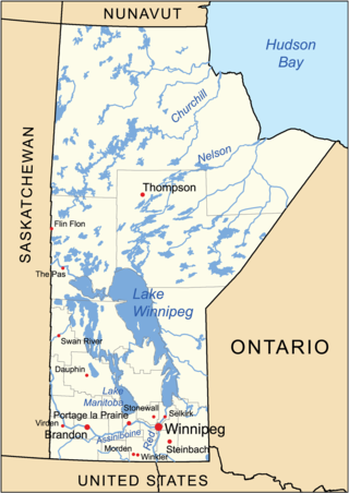
The geography of Manitoba addresses the easternmost of the three prairie Canadian provinces, located in the longitudinal centre of Canada. Manitoba borders on Saskatchewan to the west, Ontario to the east, Nunavut to the north, and the American states of North Dakota and Minnesota to the south. Although the border with Saskatchewan appears straight on large-scale maps, it actually has many right-angle corners that give the appearance of a slanted line. In elevation, Manitoba ranges from sea level on Hudson Bay to 2727 ft (831 m) on top of Baldy Mountain. The northern sixty percent of the province is on the Canadian Shield. The northernmost regions of Manitoba lie permafrost, and a section of tundra bordering Hudson Bay.
Waskesiu Lake is a lake located roughly in the centre of Prince Albert National Park. The lake's name means red deer or elk in the Cree language. Waskesiu Lake is by far the most developed lake in the park, and features a variety of recreational facilities along all sides of its shoreline, including camping, golfing, boating, and hiking. The resort village of Waskesiu Lake is on its eastern shore. The Prince Albert National Park Nature Centre is located in the village as well as many other amenities such as lodging, police, a gas station, shopping, and restaurants. Access to the lake is from Highways 263 and 264.
Lavallée Lake is a lake in the Canadian province of Saskatchewan. It is in an Important Bird Area (IBA) of Canada designated as Lavallee Lake and is the site of the second largest breeding colony of white pelicans in Canada. It is in an access-controlled area at the northern boundary of Prince Albert National Park. It is a Class I Special Protection Zone, the only such zone that fully protects a white pelican colony in Canada.

Doré Lake is a lake in the Canadian province of Saskatchewan in the basin of the Beaver River. Doré is the French Canadian term for 'walleye'. The lake is north-west of Smoothstone Lake and the Waskesiu Upland in the Mid-Boreal Upland ecozone of Canada and is surrounded by boreal forests. Saskatoon, Saskatchewan's largest city, is about 328 kilometres (204 mi) to the south. The northern village of Dore Lake is located on South Bay and is accessed from Highway 924 and Dore Lake Airport.

Pinehouse is a northern village located in the boreal forest of Saskatchewan on the western shore of Pinehouse Lake within the Canadian Shield.

Montreal River is a river in the Canadian province of Saskatchewan. It flows 100 kilometres (62 mi) from Montreal Lake to Lac la Ronge and is part of the Churchill River and Hudson Bay drainage basins. Along its course, Montreal River runs through boreal forests, muskeg, and glacier formed valleys. Within its watershed are the Waskesiu Uplands, much of Prince Albert National Park, and several notable lakes, such as Waskesiu, Kingsmere, Crean, Weyakwin, and Bittern.

Sturgeon River is a river in the Hudson Bay drainage basin in the central part of the Canadian province of Saskatchewan. It flows from its source in the Waskesiu Hills in Prince Albert National Park to the North Saskatchewan River, just west of the city of Prince Albert.
Cowan River is a river in the west-central part of the Canadian province of Saskatchewan in the boreal forest ecozone of Canada. The river begins at Cowan Lake Dam near the northern end of Cowan Lake and flows north-west through muskeg and forest to meet Beaver River. Beaver River then flows into Lac Île-à-la-Crosse and the Churchill River. The entirety of Cowen River is within the Northern Saskatchewan Administration District and while there are no communities along its course, the towns of Big River and Spiritwood are in its watershed.
Spruce River, also called Little Red River, is a river in the north-central region of the Canadian province of Saskatchewan. It begins in the Waskesiu Hills in Prince Albert National Park and flows generally in a southward direction through boreal forests, glacier carved hills and valleys, muskeg, and prairie en route to the North Saskatchewan River at the east end of the city of Prince Albert.
Waskesiu River is a river that runs through boreal forest in the north-central region of the Canadian province of Saskatchewan. It begins at Waskesiu Lake in Prince Albert National Park and flows north-east to Montreal Lake.
Waskesiu Upland is a hilly plateau in the central region of the Canadian province of Saskatchewan. Waskesiu means red deer or elk in the Cree language. The plateau is just south-west of the geographical centre of the province and consists of two main ranges — the Waskesiu Hills to the south and the Thunder Hills to the north. The Thunder Hills cover an area of about 225,000 acres. Several notable rivers begin from the upland with ones headed south flowing into the North Saskatchewan River and ones headed north flowing into the Churchill River. Much of the plateau is carpeted in boreal forests and most of the Waskesiu Hills range is within Prince Albert National Park. Besides the national park, there are several provincial recreation sites in and around the upland. The northern part of the upland is part of the Northern Saskatchewan Administration District and is sparsely populated.
Delaronde Lake is a lake in the Canadian province of Saskatchewan. It is situated at the western edge of the Waskesiu Upland in the boreal forest ecozone of Canada. Delaronde Lake is within the Churchill River drainage basin of the Hudson Bay.
Nesslin Lake is a lake in the Canadian province of Saskatchewan. It is situated at the western end of the Waskesiu Upland in the boreal forest ecozone of Canada. Nesslin Lake is within the Churchill River drainage basin of the Hudson Bay.
MacLennan River is a river in the Canadian province of Saskatchewan. It begins at MacLennan Lake in the Thunder Hills of the Northern Saskatchewan Administration District. It then flows generally south-east out of the hills, through a section of Prince Albert National Park, and on to Montreal Lake. MacLennan River is within the Churchill River drainage basin and is in the Mid-Boreal Upland ecozone of Canada.
Smoothstone Lake is a lake in the Canadian province of Saskatchewan along the course of the Smoothstone River. The lake is at the western edge of the Waskesiu Upland in the Mid-Boreal Upland ecozone of Canada and is surrounded by boreal forests. Smoothstone Lake's primary inflow and outflow is the Smoothstone River, which begins in the Waskesiu Upland and ends at Pinehouse Lake of the Churchill River. At the lake's northern end is Selenite Point, Selenite Bay, and the 362.2-hectare (895-acre) Shelter Island. Access to the lake and its amenities is from Highway 917. Highway 929 dead ends near Selenite Bay at the lake's northern end.


