| MacLennan River | |
|---|---|
 Location of the Maclennan River | |
| Location | |
| Country | New Zealand |
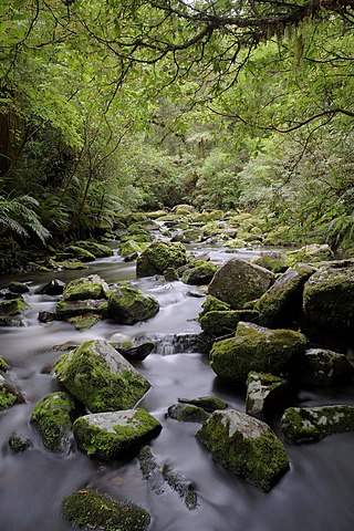
The Maclennan River is a river of New Zealand, a tributary of the Tahakopa River.
| MacLennan River | |
|---|---|
| Location of the Maclennan River | |
| Location | |
| Country | New Zealand |
The Maclennan River is a river of New Zealand, a tributary of the Tahakopa River.

The Landsborough River is located in New Zealand's South Island. A major tributary of the Haast River, it flows southwest, parallel with the Southern Alps, for 50 kilometres from its source five kilometres north of Mount Hopkins to meet the Haast 12 kilometres below the Haast Pass.
The Catlins River Branch was a branch line railway that formed part of New Zealand's national rail network. It ran through the Catlins region in southwestern Otago and was built in sections between 1879 and 1915. It closed in 1971 except for the first four kilometres, which remain open as the Finegand Branch. Along the line was the Hunts Road tunnel, the southernmost tunnel in New Zealand.

The Catlins River flows southeastward through The Catlins, an area of the southern South Island of New Zealand. Its total length is 42 kilometres (26 mi), and it flows into the Pacific Ocean at the holiday settlement of Pounawea, 28 kilometres (17 mi) south of Balclutha. Its upper estuary is called Catlins Lake, and its lower estuary is shared with the Ōwaka River. The lower estuary is also known at Pounawea Estuary.
The Tahakopa River flows southeastward through the Catlins, an area of the southern South Island of New Zealand. Its total length is 32 kilometres (20 mi), and it flows into the Pacific Ocean 30 kilometres (19 mi) east of Waikawa, close to the settlement of Papatowai. The Maclennan River is a tributary.
The Catlins Ranges are a series of rugged, roughly parallel hill ranges in the southeastern corner of New Zealand's South Island.
Maclennan is a small settlement in The Catlins, an area of the southern South Island of New Zealand. It is located 20 kilometres southwest of Owaka. From 1915 until its closure on 27 February 1971, the Catlins River Branch railway passed through the village, and the station building and goods shed still stand today.
Titiroa is a locality in the Southland region of New Zealand's South Island. It is on the eastern bank of the lower Mataura River, inland from Toetoes Bay. Pine Bush is nearby to the northeast, and Waimahaka is to the southeast.
The Fleming River is a river of the eastern Catlins, New Zealand. A tributary of the Tautuku River, it rises west of Soaker Hill in the Maclennan Range and flows south-eastward through the Catlins Forest Park to join that river at Tautuku.

Ōhinetamatea River / Saltwater Creek is a river in the Westland District of New Zealand.

The Manakaiaua River is a river of the West Coast Region of New Zealand's South Island. It flows generally northwest from its source on the slopes of Mount Ritchie in the Bare Rocky Range, part of the Southern Alps, reaching the Tasman Sea to the north of Bruce Bay.
The Ōtoko River is a river of the West Coast Region of New Zealand's South Island. It flows generally northwest from the northern slopes of Mount Hooker, reaching the Paringa River 20 kilometres south of Bruce Bay.
The Pūerua River, prior to 2018 spelled Puerua River, is a river in South Otago, New Zealand. A tributary of the Clutha River / Mata-Au, it rises east of Brown Dome and flows eastward to join that river near Port Molyneux.

The Purakaunui River is a river in the western Catlins, New Zealand. It rises west of Houipapa and flows through the Pūrākaunui Bay Scenic Reserve into the Pacific Ocean at Pūrākaunui Bay. The river is best known for Purakaunui Falls.
The Tautuku River originates in the Maclennan Range of The Catlins in New Zealand. It continues through native bush for almost its entire length, including McLean Falls. Near its mouth at Tautuku Bay, just north of Tautuku Peninsula, the river flows through the Tautuku Estuary, a breeding ground for fernbirds.
The Tīmaru River is a river of the Otago region of New Zealand's South Island. It initially flows southwest before turning west to flow into the eastern shore of Lake Hāwea, 10 kilometres (6 mi) northeast of Lake Hāwea township.
The Waipati River, alternatively known as the Chaslands River is a river in the eastern Catlins, New Zealand. It rises in the Maclennan Range and flows south-eastward into the Waipati Beach north of Chaslands Mistake.
The Waitāhuna River, known until 2019 as Waitahuna River, is a river in the Clutha District of New Zealand, a tributary of the Clutha River.
The small settlement of Caberfeidh is located in The Catlins, in the Otago region of New Zealand's South Island. The site of a former railway station on the Catlins Branch Line, it is sited close to a tributary of the Maclennan River, 5 kilometres north of the coast at Tahakopa Bay and 12 kilometres southwest of Owaka.
The Koau and Matau Rivers, also called the Koau and Matau Branches, are the two distributaries of New Zealand's Clutha River. The two distributaries split immediately to the southeast of the town of Balclutha, at which point the more northerly branch becomes the Matau and the more southerly becomes the Koau. The two branches both flow generally southeast to reach the Pacific Ocean, surrounding the island of Inch Clutha. A small silty channel connects the two rivers close to their mouths, creating a smaller unnamed island to the south of Inch Clutha.
"Place name detail: Maclennan River". New Zealand Gazetteer. New Zealand Geographic Board . Retrieved 12 July 2009.
46°33′S169°29′E / 46.550°S 169.483°E