Related Research Articles

Cottonwood is a census-designated place (CDP) in Shasta County, California, United States. The population was 3,316 at the 2010 census, up from 2,960 at the 2000 census. Cottonwood was a stagecoach town where a settlement was established in 1849. The first Post Office was opened in 1852. Cottonwood is equidistant between Redding and Red Bluff, 15 miles (24 km) in either direction. It is 4 miles (6.4 km) south of Anderson.

The Gold Country is a historic region in the northern portion of the U.S. state of California, that is primarily on the western slope of the Sierra Nevada. It is famed for the mineral deposits and gold mines that attracted waves of immigrants, known as the 49ers, during the 1849 California Gold Rush.

The Cariboo is an intermontane region of British Columbia, Canada, centered on a plateau stretching from Fraser Canyon to the Cariboo Mountains. The name is a reference to the caribou that were once abundant in the region.
Cottonwood River Provincial Park is a provincial park in British Columbia, Canada, located northeast of the confluence of the Fraser and Cottonwood Rivers in that province's North Cariboo region.
Junction Sheep Range Provincial Park is a provincial park in British Columbia, Canada, located near the confluence of the Chilcotin and Fraser Rivers on the west bank of the latter river.
Three Sisters Lake Provincial Park is a provincial park in British Columbia, Canada, located 35 km southeast of Prince George and northeast of the community of Hixon. In addition the three lakes which are the parks namesake the park protects a unique canyon feature on Government Creek.

The Nechacco sternwheeler was built for service on the Soda Creek to Fort George route on the upper Fraser River in British Columbia. She was owned by the Fort George Lumber and Navigation Company. The partners in this company were Nick Clark and Russel Peden of South Fort George, who operated a sawmill there. Nick Clark also owned the lots in that townsite and was offering them up for sale. The new steamer was intended to bring prospective property buyers to Fort George and to furnish them with supplies.

The Cassiar Country, also referred to simply as the Cassiar, is a historical geographic region of the Canadian province of British Columbia. The Cassiar is located in the northwest portion of British Columbia, just to the northeast of the Stikine Country, while to the south is the Omineca Country. The area is noted for the Cassiar gold rush of the 1870s, when Laketon became its unofficial capital. The ghost town of Cassiar is also located in the Cassiar region.
Hixon is an unincorporated community at the northern edge of the Cariboo region of the Central Interior region of British Columbia, Canada. It is part of Electoral Area E in the Regional District of Fraser-Fort George. It is located on the east (left) bank of the Fraser River, and is about midway along BC Highway 97 between the cities of Prince George (N) and Quesnel (S). It was named for Hixon Creek, which in turn is named for a 19th-century prospector in the area, by the name of Joseph Foster Hixon, who found gold here on the banks of the Fraser River back around 1866.
The Wild Horse River, formerly known as Wild Horse Creek, is a tributary of the Kootenay River, joining it near the town of Fort Steele, British Columbia, Canada. The river's canyon was the setting for the Wild Horse Creek Gold Rush and associated "war" during the gold rush of the mid-1860s.
Cottonwood River is a tributary of the Fraser River in the Central Interior of British Columbia, Canada. Rising at the confluence of the Swift River and Lightning Creek at Coldspring House in the Cariboo goldfields of the northern Cariboo Plateau, it flows northwest and then turns southwest to join the Fraser just north of the city of Quesnel, which is at the confluence of the Quesnel River with the Fraser.
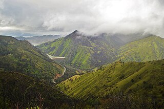
Cottonwood Canyon is a canyon along the Fraser River in the North Cariboo region of the Central Interior of British Columbia, Canada. It is located west of the Cariboo Mountains on the Fraser River south of its confluence with the east-flowing West Road River and north of its confluence with the northwest-flowing Cottonwood River just northwest of the city of Quesnel, The first European explorer was Simon Fraser (explorer) who ran the rapids on the first of June, 1808. One of his canoes became stranded and had to be pulled out of the canyon with a rope. It was one of the obstacles for gold rush-era steamboats operating on the Fraser from Quesnel to Fort George and up the Nechako and Stuart Rivers to Stuart Lake.

Cottonwood, including the Cottonwood Ranch and Cottonwood House, is an unincorporated settlement in the North Cariboo region of the Central Interior of British Columbia, Canada. Originally a ranch, it is located in the northern Cariboo Plateau, just 8 km northwest of Coldspring House, which is at the confluence of the Swift River and Lightning Creek, which is the beginning of the Cottonwood River. Lightning Creek was one of the more famous of the gold-bearing creeks of the Cariboo Gold Rush.
Granite Creek is a creek and townsite in British Columbia located in the Similkameen region. Granite Creek flows north into the Tulameen River and joins that river approximately one and a half miles to the east of Coalmont, British Columbia. It is assumed Granite Creek yielded more than $500,000 in placer gold since its discovery. Gold nuggets worth $50 in value were not unusual in the early years. The creek was mined by Europeans and Chinese. Granite Creek was hydraulicked near its mouth in the 1890s.
Lockie Creek is a creek located in the Similkameen region of British Columbia. This creek is on the west side of Otter Lake, British Columbia. Originally called Boulder Creek, the creek was mined for gold in the 1800s. Platinum was also found. In 1887, a Chinese worker unearthed a gold nugget weighing about 4 troy pounds and valued at $900. This was the largest nugget recovered from the Similkameen-Tulameen district. The nugget was kept a secret until it was sold to Wells, Fargo and Co.. The nugget was placed on exhibition in their bank located in Victoria, British Columbia.
McDame Creek is a creek in Cassiar Land District of British Columbia, Canada. The creek flows southeast into Dease River and is south of Good Hope Lake. The creek was discovered in 1874 by a prospector named Harry McDame. McDame Creek was mined for gold in the 19th century. A camp called Centreville contained cabins and stores and served as a trading centre for miners working on McDame Creek in the 19th century. In 1877 a 72 ounce solid gold nugget valued at $1,300 was found in McDame Creek. The solid gold nugget was found by a prospector named Al Freeman, it was the largest found in the province. This nugget was found roughly where 1st N. Fork Creek flows into McDame Creek.
Boundary Creek is a tributary of the Kettle River in the Boundary Country region of south central British Columbia. The creek is approximately 32 kilometres (20 mi) in length, flowing from the northeast, passing east of Midway, and only the final one-quarter mile (0.40 km) is in northeastern Washington, US.
Spruce Creek is located in the Atlin Country region of British Columbia. The creek flows into Pine Creek. Fred Marius discovered gold in this creek in 1898. In 1899 two American prospectors named West and Hoffenen found a gold nugget which weighed just over 83 ounces. The nugget was nicknamed "the west". "The west" nugget contained some quartz and thus was not the largest solid gold nugget found in British Columbia. The creek produced over 300,000 fine ounces of gold, valued at $7,000,000.
Putah Creek Wildlife Area is a state wildlife area of Solano County, California. The 670 acre reserve lies to the southeast of Lake Berryessa, to the south of Monticello Dam and the confluence of Putah Creek and Cold Creek. Trees found here include cottonwood, blue oak and chaparral. Deer, quail, California towhee, Bullock's oriole, and black-headed grosbeak are also found in the area, which also includes Stebbins Cold Canyon Reserve.
Haylmore is a location in the Bridge River Country of the southwestern Interior of British Columbia, Canada, located near the town of Gold Bridge just below the confluence of the Bridge River and its south fork, the Hurley River.
References
- ↑ "Mary Creek". BC Geographical Names.
- ↑ N.L. Barlee (1976), Historic Treasures and Lost Mines of British Columbia. Canada West Publications.
Coordinates: 53°4′N122°6′W / 53.067°N 122.100°W