Salishan oral narratives consist of the body of traditional narratives of the speakers of the Salishan languages, who inhabit British Columbia, Canada and in Montana, Idaho, Washington, and Oregon in the United States. Each of the many peoples in these groups have their own stories and each storyteller may interpret them in their own ways, but many of the stories of the Salish peoples are similar and share themes and characters, and share their historical origins in the proto-Salishan culture long ago. The earliest descriptions of the oral traditions of the Salishan peoples were the collections of Nuxalk mythology by anthropologist Franz Boas.

The Salishan languages are a family of languages of the Pacific Northwest in North America. They are characterised by agglutinativity and syllabic consonants. For instance the Nuxalk word clhp’xwlhtlhplhhskwts’, meaning "he had had [in his possession] a bunchberry plant", has twelve obstruent consonants in a row with no phonetic or phonemic vowels.

The Chehalis River is a river in Washington in the United States. It originates in several forks in southwestern Washington, flows east, then north, then west, in a large curve, before emptying into Grays Harbor, an estuary of the Pacific Ocean. The river is the largest solely contained drainage basin in the state.

The Chehalis people or Tsihalis are a Native people of western Washington state in the United States. They should not be confused with the similarly named Chehalis First Nation of the Sts'Ailes people along the Harrison River in the Fraser Valley area of British Columbia.

The Stó꞉lō, alternately written as Sto꞉lo, Stó꞉lô, or Stó꞉lõ, historically as Staulo, Stalo or Stahlo, and historically known and commonly referred to in ethnographic literature as the Fraser River Indians or Lower Fraser Salish, are a group of First Nations peoples inhabiting the Fraser Valley and lower Fraser Canyon of British Columbia, Canada, part of the loose grouping of Coast Salish nations. Stó꞉lō is the Halqemeylem word for "river", so the Stó꞉lō are the river people. The first documented reference to these people as "the Stó꞉lō" occurs in Catholic Oblate missionary records from the 1880s. Prior to this, references were primarily to individual tribal groups such as Matsqui, Ts’elxweyeqw, or Sumas.
First Nations in British Columbia constitute many First Nations governments and peoples in the province of British Columbia. Many of these Indigenous Canadians are affiliated in tribal councils. Ethnic groups include the Haida, Coast Salish, Kwakwaka'wakw, Gitxsan, Tsimshian, Nisga'a and other examples of the Pacific Northwest Coast cultures, and also various Interior Salish and Athapaskan peoples, and also the Ktunaxa.
The Chehalis River is located in the southwest corner of British Columbia, Canada near the city of Chilliwack. It flows south-eastward out of the Douglas Ranges of the Coast Mountains, draining into the Harrison River.

Harrison Hot Springs is a village located at the southern end of Harrison Lake in the Fraser Valley of British Columbia, Canada. It is a part of the Fraser Valley Regional District; its immediate neighbour is the District of Kent, which includes the town of Agassiz. As its name would suggest, it is a resort community known for its hot springs and has a population of just over 1,500 people. It is named after Benjamin Harrison, a former deputy governor of the Hudson's Bay Company.

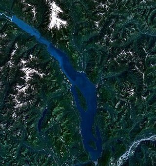
Harrison Lake is the largest lake in the southern Coast Mountains of Canada, being about 250 square kilometres (95 mi²) in area. It is about 60 km (37 mi) in length and at its widest almost 9 km (5.6 mi) across. Its southern end, at the resort community of Harrison Hot Springs, is c. 95 km east of downtown Vancouver. East of the lake are the Lillooet Ranges while to the west are the Douglas Ranges. The lake is the last of a series of large north-south glacial valleys tributary to the Fraser along its north bank east of Vancouver, British Columbia. The others to the west are the Chehalis, Stave, Alouette, Pitt, and Coquitlam Rivers. Harrison Lake is a natural lake, not man-made. The lake is supplied primarily from the Lillooet River, which flows into the lake at the northernmost point.

The Harrison River is a short but large tributary of the Fraser River, entering it near the community of Chehalis, British Columbia, Canada. The Harrison drains Harrison Lake and is the de facto continuation of the Lillooet River, which feeds the lake.

The Douglas Ranges are a subrange of the Pacific Ranges of the Coast Mountains of the Canadian province of British Columbia, about 70 km (43 mi) east of downtown Vancouver, north of the Fraser River and between the valleys of Stave and Harrison Lakes. They are approximately 4,900 km2 (1,900 sq mi) in area. Their highest peak is Mount Robertson 2,252 m (7,388 ft), at the northwest limit of the range.
Chehalis is a small forestry, agricultural and First Nations community in the Lower Mainland of British Columbia located on Highway 7 on the west bank of the Harrison River between the town of Mission and the resort community of Harrison Hot Springs.

The District of Kent is a district municipality located 116 kilometres (72 mi) east of Vancouver, British Columbia. Part of the Fraser Valley Regional District, Kent consists of several communities, the largest and most well-known being Agassiz—the only town in the municipality—Harrison Mills, Kilby, Mount Woodside, Kent Prairie, Sea Bird Island and Ruby Creek. Included within the municipality's boundaries are several separately-governed Indian reserves, including the Seabird Island First Nation's reserves on and around the island of the same name.
The Sts'ailes are an indigenous people from the Lower Mainland region of British Columbia, Canada.
The Sts'ailes Nation formerly known as Chehalis First Nation is the band government of the Sts'Ailes people, whose territories lie between Deroche and Agassiz, British Columbia. The Sts'Alies are a Halkomelem-speaking people but are distinct historically and politically from the surrounding Sto:lo peoples.
Lake Errock is a lake at the community of the same name, located between Chehalis and Deroche in the Upper Fraser Valley of the Lower Mainland region of British Columbia, Canada. It lies southwest of Harrison Bay, a sidewater of the Harrison River west of Chehalis, and is separated from the nearby Fraser River by a large rocky hill. Originally named Squakum Lake, the name was adapted to that of the Lake Errock Post Office in 1964.
Elizabeth Rose Charlie was a Sts'Ailes chief and Indigenous leader.


