Mahood River

Last updated
Sylvia Falls on Mahood River Sylvia Falls Mahood River.jpg
Sylvia Falls on Mahood River

The Mahood River is a river in the northern Shuswap Highland of the Central Interior of British Columbia in Wells Gray Provincial Park. It is 7 kilometres (4.3 mi) long from its source at Mahood Lake to its confluence with the Clearwater River, a tributary of the North Thompson River. The Mahood River has cut a deep canyon into Cambrian rocks and Pleistocene glacial moraines.

River Natural flowing watercourse

A river is a natural flowing watercourse, usually freshwater, flowing towards an ocean, sea, lake or another river. In some cases a river flows into the ground and becomes dry at the end of its course without reaching another body of water. Small rivers can be referred to using names such as stream, creek, brook, rivulet, and rill. There are no official definitions for the generic term river as applied to geographic features, although in some countries or communities a stream is defined by its size. Many names for small rivers are specific to geographic location; examples are "run" in some parts of the United States, "burn" in Scotland and northeast England, and "beck" in northern England. Sometimes a river is defined as being larger than a creek, but not always: the language is vague.

Shuswap Highland

The Shuswap Highland is a plateau-like hilly area of 14,511 km2 (5,603 sq mi) in British Columbia, Canada. It spans the upland area between the Bonaparte and Thompson Plateaus from the area of Mahood Lake, at the southeast corner of the Cariboo Plateau, southeast towards the lower Shuswap River east of Vernon in the Okanagan. The highland is not a unified range, but a combination of small uplands broken up by the valleys of the Clearwater, North Thompson and Adams Rivers and also by the lowlands in the southwest flanking Shuswap Lake. In that area of the valley are the towns of Falkland, Westwold, and Monte Creek along Highway 97. This area also includes the Spa Hills, and the other isolated pockets of hills and mini-plateaus between the Thompson Plateau proper and Shuswap Lake. The highest point of the Highland is Matterhorn Peak in the Dunn Peak massif at 2636 meters.

The British Columbia Interior, BC Interior or Interior of British Columbia, usually referred to only as the Interior, is one of the three main regions of the Canadian province of British Columbia, the other two being the Lower Mainland, which comprises the overlapping areas of Greater Vancouver and the Fraser Valley, and the Coast, which includes Vancouver Island and also including the Lower Mainland.

Contents

The Mahood River drops over two waterfalls. Sylvia Falls is 20 metres (66 ft) high and 90 metres (295 ft) wide and cascades across a glacial moraine. The falls is noticeably eroding upstream and changing its appearance faster than other waterfalls in the park, since glacial deposits are fairly soft. Only 100 metres (328 ft) downstream is Goodwin Falls which is 10 metres (33 ft) high and 60 metres (197 ft) wide. [1]

Origin of names

Nearby Mahood Lake and, later, the Mahood Falls community were named after James Adam Mahood who was in charge of a Canadian Pacific Railway survey in this area in 1872. The Mahood River and the Canim River, which feeds Mahood Lake from Canim Lake, were both originally named as part of Bridge Creek. They were renamed in 1941 and the name 'Bridge Creek' was retained only for the stream that flows into Canim Lake. [2]

Canadian Pacific Survey

The Canadian Pacific Survey or Canadian Pacific Railway Survey comprised many distinct geographical surveys conducted during the 1870s and 1880s, designed to determine the ideal route of the Canadian Pacific Railway. Although much of the survey's activity focused on locating suitable mountain passes through the Canadian Rockies, Selkirk Mountains, Monashee Mountains, Canadian Cascades and Coast Mountains of western Canada, locating the best route across the rugged terrain of the Canadian Shield north of Lake Superior was also a primary goal. The survey played an important role in the exploration of Canada, especially in the mapping of hitherto-uncharted parts of British Columbia.

The Canim River is a river in the South Cariboo region of the Interior of British Columbia, Canada. It begins at the outlet of Canim Lake and runs approximately 1.8 km to Canim Falls, the river then continues approximately 9 kilometres via a canyon cut into a lava plateau, to Mahood Lake.

Canim Lake (British Columbia) lake

Canim Lake is a lake in British Columbia, Canada. Its west end is 36 km (22.4 mi) northeast of 100 Mile House. "Canim" means a type of large canoe in the Chinook Jargon. Canim Lake is 26.5 km (16.5 mi) long. It is also part of the territory of the Shuswap First Nation where the ancestors are part of the Lake Division of the Shuswap Tribe of the Interior Nations of British Columbia. The Reilly Commission states that the 2,029 hectares region around Canim Lake are set aside for the Shuswap First Nation. In the summer of 1995, there was an archaeological evidence of an ancient civilization and evidence of carbon dated as 4,300 old.

Both Sylvia Falls and Goodwin Falls were named by photographer and author, Chess Lyons. In 1940, six months after Wells Gray Park was created, he was assigned by the B.C. Forest Service to explore and map the area. The Minister of Lands, Hon. Arthur Wellesley Gray, presented Lyons with a list of friends he wanted used in the naming of places in the park. Lyons thought this was inappropriate because he believed that place names should honor people who had been directly involved with the park such as pioneers, prospectors and trappers. However, orders had to be obeyed, so each time he passed a swamp, he dutifully assigned one of Gray’s names. However, each time he came upon a sizable creek, a waterfall or a peak he pulled his own carefully researched list from his backpack. Needless to say, Gray’s names have been lost to time, except for one - Goodwin Falls. Thirty years after his survey, Lyons commented to Helen and Philip Akrigg (British Columbia’s place name experts), "I had to hang a few names on, and Goodwin was some friend of Wells Gray. I think that was the most prominent thing named in the Park because I figured I would lead him astray with one thing while I named little insignificant things after the others that would all be forgotten. I have no idea who Goodwin was." [1] For many years, the origin of the Goodwin Falls name did remain a mystery and neither the B.C. Provincial Archives nor the Geographical Names Office could provide any clue about Goodwin. The puzzle was eventually solved by the Akriggs who learned from Gray’s niece that Walter Goodwin was a Spokane, Washington, dentist who had done some work on Gray's teeth the year before. By this chance association, he became memorialized in Wells Gray Park. The only other exception to Lyons' list of locals was Sylvia Falls which he named for his wife. [1]

C. P. Lyons Canadian outdoorsman and natural historian

Chester Peter "Chess" Lyons was a Canadian outdoorsman and natural historian. The author of several books on the flora and landscape of the Pacific Northwest, Lyons is best known for his popular and widely cited botanical field guides.

Access

A rough road from Clearwater on the Yellowhead Highway follows the west bank of the Clearwater River for 38.5 kilometres (23.9 mi) and ends at the confluence of the Mahood River and Clearwater River. A primitive campsite is located here. A trail follows the south bank of the Mahood River upstream for 4 kilometres (2.5 mi) to Sylvia and Goodwin Falls, about a one-hour walk. The trail, in poor condition, continues on to Mahood Lake, a hike of 3 kilometres (1.9 mi) that takes about 1.5 hours. The only other access to Mahood River is by boat from Mahood Lake Campground at the west end. [1]

Clearwater, British Columbia District municipality in British Columbia, Canada

Clearwater is a district municipality in the North Thompson River valley in British Columbia, Canada, where the Clearwater River empties into the North Thompson River. It is located 124 km (77 mi) north of Kamloops.

Yellowhead Highway highway in Canada

The Yellowhead Highway is a major interprovincial highway in Western Canada that runs from Winnipeg to Graham Island off the coast of British Columbia via Saskatoon and Edmonton. It stretches across the four western Canadian provinces of British Columbia, Alberta, Saskatchewan, and Manitoba and is part of the Trans-Canada Highway system and the larger National Highway System, but should not be confused with the more southerly, originally-designated Trans-Canada Highway. The highway was officially opened in 1970. Beginning in 1990, the green and white Trans-Canada logo was used to designate the roadway.

Coordinates: 51°54′58″N120°11′39″W / 51.91611°N 120.19417°W / 51.91611; -120.19417

Geographic coordinate system Coordinate system

A geographic coordinate system is a coordinate system that enables every location on Earth to be specified by a set of numbers, letters or symbols. The coordinates are often chosen such that one of the numbers represents a vertical position and two or three of the numbers represent a horizontal position; alternatively, a geographic position may be expressed in a combined three-dimensional Cartesian vector. A common choice of coordinates is latitude, longitude and elevation. To specify a location on a plane requires a map projection.

See also

Related Research Articles

Clearwater River (Saskatchewan) river in Saskatchewan, Canada

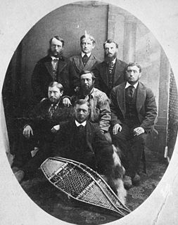
The Clearwater River is located in the Canadian provinces of Saskatchewan and Alberta. It rises in the northern forest region of northwestern Saskatchewan and joins the Athabasca River in northeastern Alberta. It was part of an important trade route during the fur trade era and has been designated as a Canadian Heritage River.

Clearwater River (British Columbia) river in Canada

The Clearwater River is the largest tributary of the North Thompson River, joining it at the community of Clearwater, British Columbia. The Clearwater rises from glaciers in the Cariboo Mountains and flows in a mostly southerly direction for 201 km (125 mi) to the North Thompson. Its entire course, except the last 5 km (3 mi), is within Wells Gray Provincial Park. Its confluence with the North Thompson is protected by North Thompson River Provincial Park.

Flourmill Volcanoes

The Flourmill Volcanoes, also known as The Flourmills, are a small volcano range near the west boundary of Wells Gray Provincial Park in east-central British Columbia, Canada. Located north of Mahood Lake and west of the Clearwater River, they form part of the Wells Gray-Clearwater volcanic field.

Clearwater Lake (British Columbia) lake in British Columbia, Canada

Clearwater Lake is one of six large lakes in Wells Gray Provincial Park in east-central British Columbia, Canada,. The Clearwater River enters the lake at its north end, flowing from Hobson Lake and Azure Lake, and also drains the lake. There are several small streams that flow into Clearwater Lake, but it has no significant tributaries.

Canim Falls

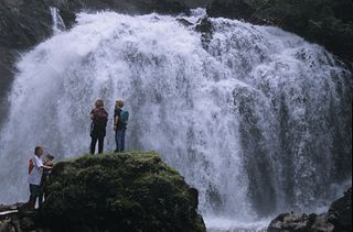
Canim Falls is a waterfall on the Canim River between Canim and Mahood Lakes in the Cariboo region of the Central Interior of British Columbia, Canada. It is 25 m (82 ft) high. The waterfall has eroded steadily upstream and created a 4 km (2.5 mi) long canyon cut into a lava plateau associated with the Wells Gray-Clearwater volcanic field. Canim Falls is inside the boundary of Wells Gray Provincial Park.

Mahood Falls

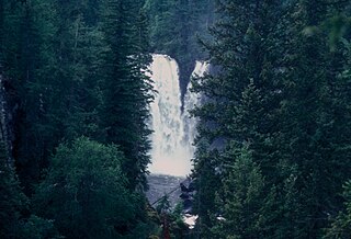
Mahood Falls is a waterfall in Wells Gray Provincial Park located on the Canim River between Canim Lake and Mahood Lake and northeast of 100 Mile House, British Columbia, Canada. The waterfall is 20 m (66 ft) high.

Mahood Lake lake in British Columbia, Canada

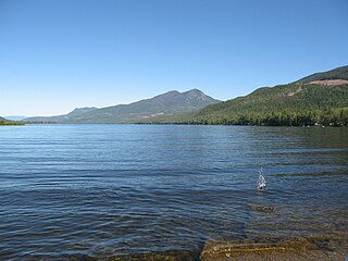
Mahood Lake is a lake in the South Cariboo region of the Interior of British Columbia in Wells Gray Provincial Park. It is drained by the Mahood River, a tributary of the Clearwater River which has cut a deep canyon into Cambrian rocks and Pleistocene glacial moraines. Mahood Lake is fed by the short Canim River, which drains nearby Canim Lake to the west via Canim Falls and Mahood Falls.

Bridge Creek is a creek in the South Cariboo region of the Interior of British Columbia, Canada. Its meandering course across the Cariboo Plateau is approximately 85 kilometres in length, beginning at Bridge Lake and running roughly westwards to the town of 100 Mile House and from there turning and running northeast to Canim Lake. Below Canim Lake the Canim River connects to Mahood Lake and the short Mahood River to the Clearwater River, which meets the North Thompson at the town of Clearwater.

Murtle River river in Canada

The Murtle River is a river in east-central British Columbia, Canada. It rises from a large unnamed glacier in the Cariboo Mountains at an elevation of 2,300 metres (7,500 ft) and flows southwest for 18 kilometres (11 mi) to the head of gigantic Murtle Lake. The river also drains Murtle Lake then flows southwest for 36 kilometres (22 mi) into the Clearwater River. The Murtle River is the longest and largest tributary to the Clearwater.

Ray Lake is a lake located in Wells Gray Provincial Park, east-central British Columbia, Canada. It is fed by and drained by Falls Creek which flows into the Clearwater River at its outlet from Clearwater Lake.

Wells Gray-Clearwater volcanic field

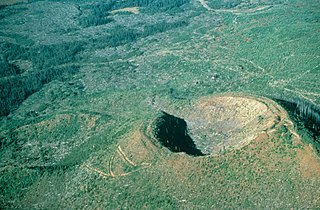
The Wells Gray-Clearwater volcanic field, also called the Clearwater Cone Group, is a potentially active monogenetic volcanic field in east-central British Columbia, Canada, located approximately 130 km (81 mi) north of Kamloops. It is situated in the Cariboo Mountains of the Columbia Mountains and on the Quesnel and Shuswap Highlands. As a monogenetic volcanic field, it is a place with numerous small basaltic volcanoes and extensive lava flows.

Horseshoe Falls (British Columbia) waterfall in British Columbia, Canada

Horseshoe Falls is one of seven waterfalls on the Murtle River west of Murtle Lake in Wells Gray Provincial Park, east-central British Columbia, Canada. Horseshoe Falls has two steps, 100 m (328 ft) apart; the upper drop is 6 m (20 ft) high and the lower and much wider drop is 10 m (33 ft) high.

Majerus Falls

Majerus Falls is one of seven waterfalls on the Murtle River west of Murtle Lake in Wells Gray Provincial Park, east-central British Columbia, Canada.

Azure Lake lake in British Columbia, Canada

Azure Lake is a fjord-like lake located in east-central British Columbia, Canada. It is an expansion of the Azure River which rises from an unnamed glacier in the Cariboo Mountains. The outflow is also called the Azure River, but it is only 50 m (164 ft) long before it flows into the Clearwater River. Azure Lake is one of the six major lakes in Wells Gray Provincial Park.

Murtle Lake is a lava dammed lake located in Wells Gray Provincial Park, east-central British Columbia, Canada. It is fed primarily by the Murtle River which rises from a large unnamed glacier in the Cariboo Mountains at an elevation of 2,300 m (7,546 ft) and flows southwest for 18 km (11 mi) to the lake. The Murtle River also drains Murtle Lake then flows southwest for 36 km (22 mi) into the Clearwater River.

Wells Gray Provincial Park provincial park

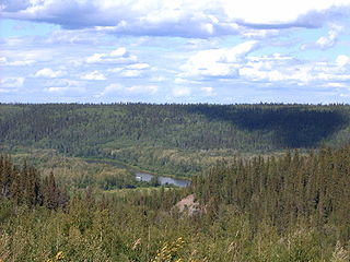
Wells Gray Provincial Park is a large wilderness park located in east-central British Columbia, Canada. The park protects most of the southern, and highest, regions of the Cariboo Mountains and covers 5,250 square kilometres. It is British Columbia's fourth largest park, after Tatshenshini, Spatsizi and Tweedsmuir.

McDiarmid Falls waterfall

McDiarmid Falls is a waterfall on Grouse Creek in Wells Gray Provincial Park, east-central British Columbia, Canada. It is located 100 m (328 ft) downstream from Moul Falls and 150 m (492 ft) upstream from Grouse Creek's confluence with the Clearwater River.

Mount Lloyd George mountain in Canada

Mount Lloyd George is a 2,938 metres (9,639 ft) peak in British Columbia, Canada, rising to a prominence of 1,208 metres (3,963 ft) above Lloyd George Pass. Its line parent is Mount Sylvia, 37 kilometres (23 mi) away. It is part of the Northern Rocky Mountains.

References

  1. 1 2 3 4 Neave, Roland (2015). Exploring Wells Gray Park, 6th edition. Wells Gray Tours, Kamloops, BC. ISBN   978-0-9681932-2-8.
  2. "Mahood River". BC Geographical Names.