
Shuswap Lake is a lake located in the southern interior of British Columbia, Canada that drains via the Little Shuswap River into Little Shuswap Lake. Little Shuswap Lake is the source of the South Thompson River, a branch of the Thompson River, a tributary of the Fraser River. It is at the heart of a region known as the Columbia Shuswap or "the Shuswap", noted for its recreational lakeshore communities including the city of Salmon Arm. The name "Shuswap" is derived from the Shuswap or Secwepemc First Nations people, the most northern of the Interior Salish peoples, whose territory includes the Shuswap. The Shuswap call themselves /ʃǝxwépmǝx/ in their own language, which is called /ʃǝxwepmǝxtʃín/.

Chase is a village located in the Interior of British Columbia, Canada. It has a population of roughly 3,124, and its main industries are forestry and tourism. It is located at the outlet of Little Shuswap Lake, which is the source of the South Thompson River. Chase Creek, which drops over three small waterfalls before flowing through the town, enters the South Thompson just below the lake's outlet.
The basin of the Shuswap River lies northeast of the Okanagan Valley in British Columbia, originating in the central Monashee Mountains. It is the upper part of the drainage better known to British Columbians as belonging to Shuswap Lake and the South Thompson River. The river's drainage basin is over 1,969 square kilometres (760 sq mi) in area.
Inland Lake Provincial Park is a provincial park in British Columbia, Canada, located on the southeast side of Powell Lake, just to the northeast of the city of Powell River in that province's northern Sunshine Coast region. Inland Lake is located between the south end of Powell Lake (W) and Haslam Lake (E).

Shuswap Lake Provincial Park is a provincial park in British Columbia, Canada.
Shuswap Lake Marine Provincial Park is a provincial park in British Columbia, Canada, comprising 894 ha. The Park has a variety of amenities including boat launch ramps, picnic areas, and 27 campsites around the perimeter of Shuswap Lake. The lake's name and that of the surrounding Shuswap Country is from the Shuswap people (Secwepemc), the most northern of the Salishan speaking people.
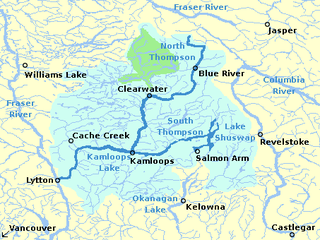
The South Thompson River is the southern branch of the Thompson River, the largest tributary of the Fraser River, in the Canadian province of British Columbia. It originates at the outlet of Little Shuswap Lake at the town of Chase and flows approximately 58 kilometres (36 mi) southwest and west through a wide valley to Kamloops where it joins the North Thompson River to form the main stem Thompson River.
The High Bar First Nation is a First Nations government of the Secwepemc (Shuswap) Nation, located in the Fraser Canyon-Cariboo region of the Central Interior of the Canadian province of British Columbia. It was created when the government of the then-Colony of British Columbia established an Indian reserve system in the 1860s. It is one of three Secwepemc bands that is not a member of either the Shuswap Nation Tribal Council or the Northern Shuswap Tribal Council. The High Bar people are also partly Tsilhqot'in and have links with some Chilcotin First Nations.
The Esk'etemc First Nation, also known as the Alkali Lake Indian Band, is a First Nations government of the Secwepemc (Shuswap) people, located at Alkali Lake in the Cariboo region of the Central Interior of the Canadian province of British Columbia. It was created when the government of the then-Colony of British Columbia established an Indian reserve system in the 1860s. It is one of three Secwepemc bands that is not a member of either the Shuswap Nation Tribal Council or the Northern Shuswap Tribal Council.

The Robson Valley is a geographic region of the Canadian province of British Columbia, comprising the section of the Rocky Mountain Trench that lies southeast of the city of Prince George following the Fraser River to the Yellowhead Pass. The name is derived from Mount Robson, which stands near the entrance to the Yellowhead Pass. Communities in the Robson Valley include the settlements of Dome Creek, Crescent Spur, Dunster, and Tête Jaune Cache, with larger population concentrations in the villages of McBride and Valemount. On a map, the Robson Valley is located immediately south of the elbow in the boundary between Alberta and British Columbia. Transportation corridors through the Robson Valley include the Canadian National Railway lines, and Highways 16 and 5.

The Shuswap Country, or simply the Shuswap and called Secwepemcúl̓ecw in Secwepemctsín, is a term used in the Canadian province of British Columbia to refer to the environs of Shuswap Lake. The upper reaches of the Shuswap basin, southeast of Shuswap Lake and northeast of the Okanagan, are generally considered to be part of Okanagan or of the Monashee Country rather than "the Shuswap". Roughly defined, the Shuswap Country begins on its west at the town of Chase, located on Little Shuswap Lake, west of which is the South Thompson area of the Thompson Country, and includes Adams Lake to the northwest of Shuswap Lake as well as communities in the Eagle River area as far as Craigellachie and/or Three Valley Gap, which is at the summit of Eagle Pass, beyond which eastwards is the Columbia Country.
The Little River is a 35 km river in the Cariboo region of British Columbia, Canada, rising in the Cariboo Mountains north of the North Arm of Quesnel Lake and running roughly westwards to enter Cariboo Lake conjointly with the upper Cariboo River.
Little River is a community in the Comox Valley region of Vancouver Island, British Columbia, Canada.
The Little River is a tributary of Little River Bay in the Comox Valley region of Vancouver Island, British Columbia, Canada and the namesake of the community of Little River. Little River Bay is an arm of the Strait of Georgia.

The Adams River is a tributary to the Thompson and Fraser Rivers in British Columbia, Canada. Beginning in the Monashee Mountains to the north, the Upper Adams River flows mainly southward and eventually reaches Adams Lake. The Lower Adams River begins at the southern end of the lake and flows into the extreme western end of Shuswap Lake. The river is one of the most important sockeye salmon breeding areas in North America. The run occurs in mid-October and can bring millions of fish to a concentrated area near the river mouth. Excavations of Secwepemc villages on the river have shown a long tradition of habitation and salmon fishing in the area. The river also served as an important transportation route for early logging operations in the watershed.
Lejac is a locality on the Canadian National Railway line in the Nechako Country region of British Columbia, located on the south shore of Fraser Lake between the communities of Fraser Lake (W) and Fort Fraser (E).
