Rivers Inlet is a fjord in the Central Coast region of the Canadian province of British Columbia, its entrance off Fitz Hugh Sound, about 125 km (78 mi) southwest of the community of Bella Coola and about 65 km (40 mi) north of the northern tip of Vancouver Island and the western entrance of the Queen Charlotte Strait.

The Homathko River is one of the major rivers of the southern Coast Mountains of the Canadian province of British Columbia. It is one of the few rivers that penetrates the range from the interior Chilcotin Country to the coastal inlets of the Pacific Ocean. The Homathko River reaches the sea at the head of Bute Inlet, just west of the mouth of the Southgate River.
The Bella Coola River is a major river on the Pacific slope of the Coast Mountains in southern British Columbia. The town of Bella Coola is at its mouth on North Bentinck Arm. Bella Coola Indian Reserve No. 1 the location of the main community today of the surviving population of the Nuxalk who gathered there after depredations by smallpox and colonialization.
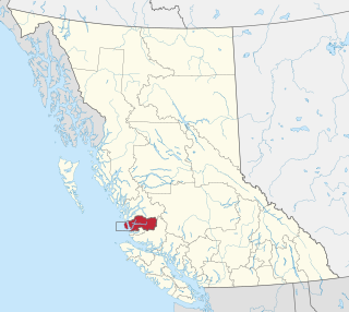
The Wuikinuxv Nation, also known as the Oweekeno Nation, is a First Nations band government whose traditional territory is the shores of Rivers Inlet and Owikeno Lake in the Central Coast region of the Canadian province of British Columbia, in the area south of Bella Bella and north of Queen Charlotte Strait. The Wuikinuxv people a.k.a. the Oweekeno people reside in the area of Rivers Inlet and Owikeno Lake, primarily at a village on the Wannock River. Substantial numbers of Wuikinuxv also reside away from the traditional territory in Port Hardy on Vancouver Island and in larger BC communities such as Campbell River, Vancouver and Victoria. Approximately 80 people reside at the village while overall membership was 283 in 2006, 194 of whom lived off-reserve.
The WuikinuxvIPA: [ʔuwik'inuxʷ],, also rendered Oweekano (Pre-1976); Oowekeeno (1976-2003) are an Indigenous First Nations people of the Central Coast region of the Canadian province of British Columbia, located around Rivers Inlet and Owikeno Lake, to the north of Queen Charlotte Strait. The Wuikinuxv people and their neighbours the Heiltsuk and Haisla peoples were in the past sometimes known incorrectly as the "Northern Kwakiutl".

The Powell River is a river in the northern Sunshine Coast region of British Columbia, Canada that flows a short distance through the eponymous city of Powell River, British Columbia to enter the Salish Sea. It is one of the shortest rivers in the world, measuring 500 Meters in length.
Owikeno Lake, also Owekeeno Lake, Owekano Lake, Oweekayno Lake and other spellings, is a large fjord lake in the Central Coast region of British Columbia, Canada. It connects to the head of Rivers Inlet by the short Wannock River (Wanukv). The lake's name comes from the indigenous people of the region, the Wuikinuxv, whose settlements and territory lie around the lake. Their largest and principal settlement was on an island in the lower reaches of the lake named Katit.

The Kitlope River is a river in the Kitimat Ranges in the North Coast of British Columbia, Canada, flowing north for 100 km (62 mi), into the head of the Gardner Canal to the south of the smelter town of Kitimat. It is named for the Gitlope group of Haisla, now part of the Haisla Nation government and community at Kitamaat Village near Kitimat. The name is a Tsimshian language reference to the people, who call themselves Henaksiala, and means "people of the rocks" or "people of the opening in the mountains". The Haisla language name for the river is Xesduwaxwsdu.
Rivers Inlet is an unincorporated settlement and First Nations community of the Wuikinuxv (Owikeno) people, located at the head of the inlet of the same name in the Central Coast region of British Columbia, Canada. The community is located adjacent to the Wannock River, a short waterway connecting Owikeno Lake to the head of Rivers Inlet.
The Hackett River is a tributary of the Sheslay River in northwest part of the province of British Columbia, Canada. It flows generally northwest about 33 km (21 mi), through two lakes, a wetland, and a gorge, to join the Sheslay River, which in turn is a tributary of the Inklin River, the main southeast fork of the Taku River.
Katit Indian Reserve No. 1 is the main Indian reserve of the Wuikinuxv people, and is one of the three reserves governed by the Wuikinuxv Nation band government. It is located in British Columbia, Canada, on the entrance to Owikeno Lake on the north side of the Wannock River near to, but separate from, the non-native community and sport fishing resort of Rivers Inlet. Similarly named Katit Island is in the Wannock River at 51°40′41″N127°11′48″W, while Kahtit Creek is downstream, near the mouth of the Wannock River at 51°40′47″N127°15′00″W near the Wuikinuxv village known as Oweekeno.
Cockmi Indian Reserve No. 3, officially Cockmi 3, is one of the three Indian reserves of the Wuikinuxv Nation band government located on the west tip of Walbran Island, which is near Darby Channel in the area of Fitz Hugh Sound on the Central Coast of British Columbia, Canada. The other two Wuikinuxv reserves are Kiltala Indian Reserve No. 2 on the Kilbella River near Kilbella Bay and Katit Indian Reserve No. 1, up the Wannock River from the community of Rivers Inlet at the entrance to Owikeno Lake.

The Nekite River is a river in the Central Coast region of British Columbia, Canada, flowing south to the head of Smith Inlet. Nekite Indian Reserve No. 2 is located at the mouth of the river and is one of the many reserves of the Gwa'sala-'Nakwaxda'xw Nations band government located in the area of Smith Sound, of which Smith Inlet is the uppermost part.
The Nahwitti River is a 40-kilometre (25 mi) long river in northernmost Vancouver Island, British Columbia, Canada. It flows through Cape Scott Provincial Park into Goletas Channel near Hope Island and Queen Charlotte Sound. Its watershed, 229 km2 (88 sq mi) large, is located west and northwest of Port Hardy, north and northeast of Holberg, and north of Holberg Inlet, part of Quatsino Sound.
The Ecstall River is a tributary of the Skeena River in the province of British Columbia, Canada. It originates in the Kitimat Ranges, and flows about 110 km (68 mi) to the lower tidal reach of the Skeena River at Port Essington, about 30 km (19 mi) southeast of Prince Rupert, 95 km (59 mi) southwest of Terrace, and 85 km (53 mi) northwest of Kitimat. Its drainage basin covers about 1,485 km2 (573 sq mi) and contains the largest blocks of unlogged land on the north coast of British Columbia, although large-scale industrial logging operations, both active and proposed, have been occurring in the watershed since the 1980s.
The Gitnadoix River is a tributary of the Skeena River in the province of British Columbia, Canada. It originates in the Kitimat Ranges, and flows about 38 km (24 mi) north to the Skeena River, about 45 km (28 mi) west of Terrace.
The Zymagotitz River is a tributary of the Skeena River located in the North Coast Regional District of the province of British Columbia, Canada. It originates in the Kitimat Ranges of the Coast Mountains, and flows south and west about 45 km (28 mi) to the Skeena River, about 10 km (6.2 mi) downriver from Terrace and about 100 km (62 mi) east of Prince Rupert.
The Khtada River is a tributary of the Skeena River in the North Coast Regional District of the province of British Columbia, Canada. It originates in the Kitimat Ranges of the Coast Mountains, and flows south about 26 km (16 mi) to the lower tidal reach of the Skeena River, about 24 km (15 mi) upriver from Port Essington, 48 km (30 mi) southeast of Prince Rupert, and about 74 km (46 mi) southwest of Terrace.
Classy Creek is a tributary of the Tuya River in northwest part of the province of British Columbia, Canada. It flows generally southeast and south roughly 20 km (12 mi) to join the Tuya River about 10 km (6.2 mi) north of the Tuya River's confluence with the Stikine River in the Grand Canyon of the Stikine, near Telegraph Creek Road, unofficially called Highway 51, a spur of the Stewart–Cassiar Highway.
Hartz Creek is a tributary of the Tahltan River, part of the Stikine River watershed in northwest part of the province of British Columbia, Canada. It flows generally south and southwest for roughly 14 km (8.7 mi) to join the Tahltan River about 4.5 km (2.8 mi) north of Tahltan, British Columbia at the Tahltan River's confluence with the Stikine River. Hartz Creek's watershed covers 39.1 km2 (15.1 sq mi), and its mean annual discharge is estimated at 0.315 m3/s (11.1 cu ft/s). The mouth of Hartz Creek is located about 18 km (11 mi) northeast of Telegraph Creek, British Columbia, about 73 km (45 mi) southwest of Dease Lake, British Columbia, and about 200 km (120 mi) east of Juneau, Alaska. Hartz Creek's watershed's land cover is classified as 44.2% shrubland, 30.7% mixed forest, 20.8% conifer forest, and small amounts of other cover.
