Related Research Articles
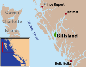
Gil Island is an island on the North Coast of British Columbia, Canada, located on the west side of Whale Channel in the entrance to Douglas Channel, one of the main coastal inlets, on the route of the Inside Passage between Pitt Island and Princess Royal Island. It is 26 km (16 mi) long, with a width ranging from 6 to 13 km, and an area of 231 km2. The only named summit on the mountainous island is Mount Gil, which faces the opening of Douglas Channel.

The Gwa'Sala-Nakwaxda'xw Nations are a union of two Kwakwaka'wakw peoples in a band government based on northern Vancouver Island in British Columbia, Canada, whose main reserve community is near the town of Port Hardy in the Queen Charlotte Strait region of the Central Coast region of British Columbia, Canada. The band government is a member of the Kwakiutl District Council and, for treaty negotiation purposes, the Winalagalis Treaty Group which includes three other members of the Kwakiutl District Council.

The Stswecem'c Xgat'tem First Nation, formerly known as Canoe Creek Band/Dog Creek Indian Band, created as a result of merger of the Canoe Creek Band and Dog Creek Band is a First Nations government of the Secwepemc (Shuswap) Nation, located in the Fraser Canyon-Cariboo region of the Central Interior of the Canadian province of British Columbia. It was created when the government of the then-Colony of British Columbia established an Indian reserve system in the 1860s. It is a member government of the Northern Shuswap Tribal Council.
The Ashcroft First Nation is a First Nations government Thompson Canyon area of the Central Interior of the Canadian province of British Columbia. Its Indian Reserves are located near the town of Ashcroft, British Columbia, it is a member of the Nlaka'pamux Nation Tribal Council.
The Lytton First Nation, a First Nations band government, has its headquarters at Lytton in the Fraser Canyon region of the Canadian province of British Columbia. While it is the largest of all Nlaka'pamux bands, unlike all other governments of the Nlaka'pamux (Thompson) people, it is not a member of any of the three Nlaka'pamux tribal councils, which are the Nicola Tribal Association, the Fraser Canyon Indian Administration and the Nlaka'pamux Nation Tribal Council.
The Tŝideldel First Nation is the band government of the Tsi Del Del subgroup of the Tsilhqot'in people, located in the Chilcotin District in the western Central Interior region of the Canadian province of British Columbia. It is a member of the Tsilhqot'in National Government.
The Stone First Nation or Yunesitʼin First Nation is a band government of the Yunesit'in subgroup of the Tsilhqot'in people, whose territory is the Chilcotin District in the western Central Interior region of the Canadian province of British Columbia. It is a member of the Tsilhqot'in Tribal Council. The people of the Stone First Nation are known as the Yunesit'in in the Chilcotin language.
The Tlʼetinqox-tʼin Government Office is a First Nations government located in the Chilcotin District in the western Central Interior region of the Canadian province of British Columbia. Governing a reserve communities near Alexis Creek known as Anaham Reserve First Nations or Anaham, it is a member of the Tsilhqotʼin Tribal Council aka known as the Tsilhqotʼin National Government. The main reserve is officially known as Anahim's Flat No. 1, and is more commonly as Anaham. Other reserves are Anahim's Meadow No. 2 and 2A, and Anahim Indian Reserves Nos. 3 through 18. Anaham, or Anahim and Alexis were chiefs of the Tsilhqotʼin during the Chilcotin War of 1864, although they and their people did not take part in the hostilities.
The Wuikinuxv Nation, also known as the Oweekeno Nation, is a First Nations band government whose traditional territory is the shores of Rivers Inlet and Owikeno Lake in the Central Coast region of the Canadian province of British Columbia, in the area south of Bella Bella and north of Queen Charlotte Strait. The Wuikinuxv people a.k.a. the Oweekeno people reside in the area of Rivers Inlet and Owikeno Lake, primarily at a village on the Wannock River. Substantial numbers of Wuikinuxv also reside away from the traditional territory in Port Hardy on Vancouver Island and in larger BC communities such as Campbell River, Vancouver and Victoria. Approximately 80 people reside at the village while overall membership was 283 in 2006, 194 of whom lived off-reserve.
The Katzie First Nation or Katzie Nation is the band government of the Katzie people of the Lower Fraser Valley region of British Columbia, Canada.
The Hartley Bay Indian Band is also known as the Gitga'at First Nation or the Hartley Bay First Nation. The members of the Gitga'at First nation are often referred to as Gitka'a'ata. The population of Gitk’a’ata peoples living in Hartley Bay ranges from approximately 130-200 people. There are also about 400-500 Gitk’a’ata peoples living in Prince Rupert, British Columbia, Canada, a neighboring territory. The Gitk’a’ata people have lived in Hartley Bay for hundreds of years, if not always. Some notable things regarding the Gitga'at First Nation are their economy, geography, government, sports involvement, COVID-19 regulations, and relations.
The Wannock River is a short river in the Central Coast region of British Columbia, Canada, draining Owikeno Lake and entering Rivers Inlet at the head of that inlet, adjacent to the town of the same name, which is the main modern settlement of the Wuikinuxv (Owikeno) people. Katit Indian Reserve No. 1 is located around the banks of the river, including Katit Island, which is an island in the river.
Yale First Nation is a First Nations government located at Yale, British Columbia. Yale has 16 distinct reserves stretching from near Sawmill Creek to American Creek, with the most southern reserve situated at Ruby Creek in the District of Kent.
Canoe Creek Indian Reserve No. 1, referred to by Statistics Canada as Canoe Creek 1, is an Indian reserve of the Canoe Creek Band/Dog Creek Indian Band of the Secwepemc people, located five miles northeast of the confluence of Canoe Creek with the Fraser River in British Columbia, Canada, in that province's Cariboo district. The reserve is 37.2 ha. in size.
Canoe Creek Indian Reserve No. 3, known officially as Canoe Creek 3, is an Indian reserve governed by the Canoe Creek/Dog Creek Indian Band, located four miles south of the mouth of Dog Creek into the Fraser River.
Kilbella Bay is a bay on the Central Coast of British Columbia, Canada, off the north side of Rivers Inlet to the northeast of McAllister Point. A steamer landing formerly operated by the Northland Navigation Company was located on the east side of the bay.
Cockmi Indian Reserve No. 3, officially Cockmi 3, is one of the three Indian reserves of the Wuikinuxv Nation band government located on the west tip of Walbran Island, which is near Darby Channel in the area of Fitz Hugh Sound on the Central Coast of British Columbia, Canada. The other two Wuikinuxv reserves are Kiltala Indian Reserve No. 2 on the Kilbella River near Kilbella Bay and Katit Indian Reserve No. 1, up the Wannock River from the community of Rivers Inlet at the entrance to Owikeno Lake.
The Nicknaqueet River is a river in the Central Coast region of British Columbia, Canada, flowing north into the head of Rivers Inlet just south of the mouth of the Wannock River.
Naysash Inlet is an inlet on the Central Coast of British Columbia, Canada, branching off the north side of Smith Inlet in the Smith Sound area. Naysash Bay is located just inside the entrance to Naysash Inlet at 51°18′59″N127°20′35″W. Naysash Creek, formerly Boulder Creek, flows southwest into Naysash Inlet at 51°20′21″N127°19′15″W.
Long Lake is a lake south of the head of Smith Inlet in the Central Coast region of British Columbia, Canada. It flows west into the Smith Inlet and its main tributary is Smokehouse Creek at its north-east end.
References
51°41′00″N127°12′00″W / 51.68333°N 127.20000°W